
File:Wpdistricts1.svg

Size of this PNG preview of this SVG file: 453 × 600 pixels. Other resolutions: 181 × 240 pixels | 362 × 480 pixels | 580 × 768 pixels | 773 × 1,024 pixels | 1,546 × 2,048 pixels | 1,181 × 1,564 pixels.
Original file (SVG file, nominally 1,181 × 1,564 pixels, file size: 112 KB)
| This is a file from the Wikimedia Commons. Information from its description page there is shown below. Commons is a freely licensed media file repository. You can help. |
Summary
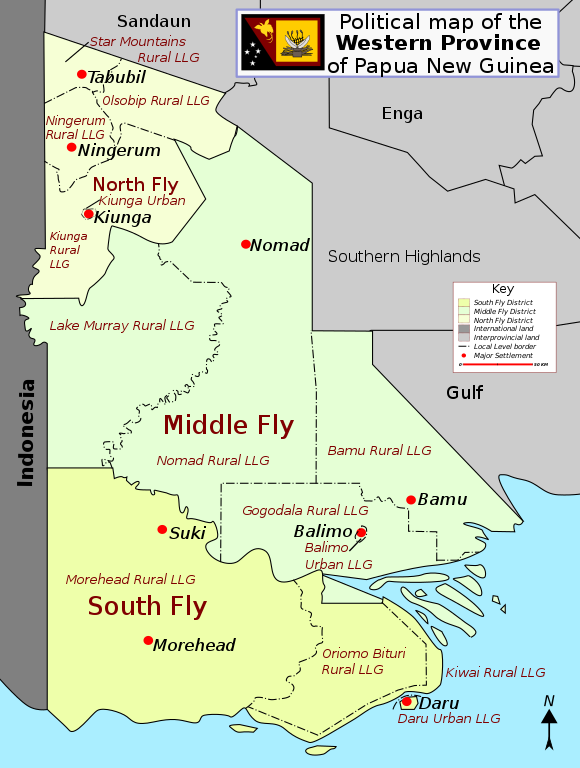
| Description | District map of Papua New Guinea |
| Date | |
| Source | Own work |
| Author | Alaisd |
Licensing
| This work has been released into the public domain by its author, I, Alaisd. This applies worldwide. In some countries this may not be legally possible; if so: I, Alaisd grants anyone the right to use this work for any purpose, without any conditions, unless such conditions are required by law. |
File history
Click on a date/time to view the file as it appeared at that time.
| Date/Time | Thumbnail | Dimensions | User | Comment | |
|---|---|---|---|---|---|
| current | 06:11, 12 July 2007 | | 1,181 × 1,564 (112 KB) | Aliasd | |
| 15:30, 11 July 2007 |  | 535 × 703 (67 KB) | Aliasd | ||
| 09:58, 10 July 2007 |  | 535 × 703 (33 KB) | Aliasd | == Summary == {{Information |Description=District map of Papua New Guinea |Source=self-made |Date=2007 |Author= Alaisd }} == Licensing == {{PD-self|author=I, Alaisd}} |
File usage
The following pages on the English Wikipedia use this file (pages on other projects are not listed):
- Balimo Urban LLG
- Bamu Rural LLG
- Daru Urban LLG
- Districts of Papua New Guinea
- Gogodala Rural LLG
- Kiwai Rural LLG
- Lake Murray Rural LLG
- Local-level governments of Papua New Guinea
- Morehead Rural LLG
- Nomad Rural LLG
- Oriomo-Bituri Rural LLG
- South Fly District
- Western Province (Papua New Guinea)
- User:Aliasd/Images/Maps
Global file usage
The following other wikis use this file:
- Usage on als.wikipedia.org
- Usage on de.wikipedia.org
- Usage on fa.wikipedia.org
- Usage on fr.wikipedia.org
- Usage on it.wikipedia.org
- Usage on nl.wikipedia.org
- Usage on pl.wikipedia.org
- Usage on uk.wikipedia.org
- Usage on www.wikidata.org
- Usage on zh.wikipedia.org