
Forest Hills–71st Avenue station
Forest Hills–71 Avenue | |||||||||||||||||||||||||||||||||||||||||||||||||||||||||||||||||||||||||||||||||||||||||||||||||||||||||||||||||||||||||||||||||||
|---|---|---|---|---|---|---|---|---|---|---|---|---|---|---|---|---|---|---|---|---|---|---|---|---|---|---|---|---|---|---|---|---|---|---|---|---|---|---|---|---|---|---|---|---|---|---|---|---|---|---|---|---|---|---|---|---|---|---|---|---|---|---|---|---|---|---|---|---|---|---|---|---|---|---|---|---|---|---|---|---|---|---|---|---|---|---|---|---|---|---|---|---|---|---|---|---|---|---|---|---|---|---|---|---|---|---|---|---|---|---|---|---|---|---|---|---|---|---|---|---|---|---|---|---|---|---|---|---|---|---|---|
 View down southbound express track | |||||||||||||||||||||||||||||||||||||||||||||||||||||||||||||||||||||||||||||||||||||||||||||||||||||||||||||||||||||||||||||||||||
| Station statistics | |||||||||||||||||||||||||||||||||||||||||||||||||||||||||||||||||||||||||||||||||||||||||||||||||||||||||||||||||||||||||||||||||||
| Address | 71st Avenue & Queens Boulevard Forest Hills, NY 11375 | ||||||||||||||||||||||||||||||||||||||||||||||||||||||||||||||||||||||||||||||||||||||||||||||||||||||||||||||||||||||||||||||||||
| Borough | Queens | ||||||||||||||||||||||||||||||||||||||||||||||||||||||||||||||||||||||||||||||||||||||||||||||||||||||||||||||||||||||||||||||||||
| Locale | Forest Hills | ||||||||||||||||||||||||||||||||||||||||||||||||||||||||||||||||||||||||||||||||||||||||||||||||||||||||||||||||||||||||||||||||||
| Coordinates | 40°43′17″N 73°50′38″W / 40.721404°N 73.844004°W | ||||||||||||||||||||||||||||||||||||||||||||||||||||||||||||||||||||||||||||||||||||||||||||||||||||||||||||||||||||||||||||||||||
| Division | B (IND)[1] | ||||||||||||||||||||||||||||||||||||||||||||||||||||||||||||||||||||||||||||||||||||||||||||||||||||||||||||||||||||||||||||||||||
| Line | IND Queens Boulevard Line | ||||||||||||||||||||||||||||||||||||||||||||||||||||||||||||||||||||||||||||||||||||||||||||||||||||||||||||||||||||||||||||||||||
| Services | E F M R | ||||||||||||||||||||||||||||||||||||||||||||||||||||||||||||||||||||||||||||||||||||||||||||||||||||||||||||||||||||||||||||||||||
| Transit | |||||||||||||||||||||||||||||||||||||||||||||||||||||||||||||||||||||||||||||||||||||||||||||||||||||||||||||||||||||||||||||||||||
| Structure | Underground | ||||||||||||||||||||||||||||||||||||||||||||||||||||||||||||||||||||||||||||||||||||||||||||||||||||||||||||||||||||||||||||||||||
| Platforms | 2 island platforms cross-platform interchange | ||||||||||||||||||||||||||||||||||||||||||||||||||||||||||||||||||||||||||||||||||||||||||||||||||||||||||||||||||||||||||||||||||
| Tracks | 4 | ||||||||||||||||||||||||||||||||||||||||||||||||||||||||||||||||||||||||||||||||||||||||||||||||||||||||||||||||||||||||||||||||||
| Other information | |||||||||||||||||||||||||||||||||||||||||||||||||||||||||||||||||||||||||||||||||||||||||||||||||||||||||||||||||||||||||||||||||||
| Opened | December 31, 1936 | ||||||||||||||||||||||||||||||||||||||||||||||||||||||||||||||||||||||||||||||||||||||||||||||||||||||||||||||||||||||||||||||||||
| Accessible | |||||||||||||||||||||||||||||||||||||||||||||||||||||||||||||||||||||||||||||||||||||||||||||||||||||||||||||||||||||||||||||||||||
| Opposite- direction transfer | Yes | ||||||||||||||||||||||||||||||||||||||||||||||||||||||||||||||||||||||||||||||||||||||||||||||||||||||||||||||||||||||||||||||||||
| Former/other names | 71st–Continental Avenues–Forest Hills | ||||||||||||||||||||||||||||||||||||||||||||||||||||||||||||||||||||||||||||||||||||||||||||||||||||||||||||||||||||||||||||||||||
| Traffic | |||||||||||||||||||||||||||||||||||||||||||||||||||||||||||||||||||||||||||||||||||||||||||||||||||||||||||||||||||||||||||||||||||
| 2023 | 5,509,732[2] | ||||||||||||||||||||||||||||||||||||||||||||||||||||||||||||||||||||||||||||||||||||||||||||||||||||||||||||||||||||||||||||||||||
| Rank | 42 out of 423[2] | ||||||||||||||||||||||||||||||||||||||||||||||||||||||||||||||||||||||||||||||||||||||||||||||||||||||||||||||||||||||||||||||||||
| |||||||||||||||||||||||||||||||||||||||||||||||||||||||||||||||||||||||||||||||||||||||||||||||||||||||||||||||||||||||||||||||||||
| |||||||||||||||||||||||||||||||||||||||||||||||||||||||||||||||||||||||||||||||||||||||||||||||||||||||||||||||||||||||||||||||||||
| |||||||||||||||||||||||||||||||||||||||||||||||||||||||||||||||||||||||||||||||||||||||||||||||||||||||||||||||||||||||||||||||||||
| |||||||||||||||||||||||||||||||||||||||||||||||||||||||||||||||||||||||||||||||||||||||||||||||||||||||||||||||||||||||||||||||||||
| |||||||||||||||||||||||||||||||||||||||||||||||||||||||||||||||||||||||||||||||||||||||||||||||||||||||||||||||||||||||||||||||||||
| |||||||||||||||||||||||||||||||||||||||||||||||||||||||||||||||||||||||||||||||||||||||||||||||||||||||||||||||||||||||||||||||||||


The Forest Hills–71st Avenue station (previously known as 71st–Continental Avenues station) is an express station on the IND Queens Boulevard Line of the New York City Subway, located on Queens Boulevard at 71st (Continental) Avenue in Forest Hills, Queens. It is served by the E and F trains at all times, the <F> train during rush hours in the reverse peak direction, the M train on weekdays during the day, and the R train at all times except late nights. It serves as the terminus for the M and R services.
History[edit]

The Queens Boulevard Line was one of the first lines built by the city-owned Independent Subway System (IND),[4][5][6] and stretches between the IND Eighth Avenue Line in Manhattan and 179th Street and Hillside Avenue in Jamaica, Queens.[4][6][7] One of the proposed stations would have been located at 71st Avenue. During the late 1920s, in anticipation of the arrival of the subway, land was bought by developers and was built up.[8] Zoning laws were changed to allow fifteen-story apartment buildings to be built,[9] and made the neighborhood of Forest Hills a more desirable place to live, especially as it was an express stop. Queens Borough President George Harvey predicted that the introduction of the subway to Forest Hills would turn Queens Boulevard into the "Park Avenue of Queens."[8]: 73
The first section of the line opened on August 19, 1933 from the connection to the Eighth Avenue Line at 50th Street to Roosevelt Avenue in Jackson Heights.[10] Later that year, a $23 million loan was approved to finance the remainder of the line, along with other IND lines.[11] The remainder of the line was built by the Public Works Administration.[12][13] In 1934 and 1935, construction of the extension to Jamaica was suspended for 15 months and was halted by strikes.[14] Construction was further delayed due to a strike in 1935, instigated by electricians opposing wages paid by the General Railway Signal Company.[15] By August 1935, work had resumed on the 71st Avenue station and three other stations on the Queens Boulevard Line.[16] In August 1936, tracks were installed all the way to 178th Street, and the stations to Union Turnpike were completed.[14]
On December 31, 1936, the IND Queens Boulevard Line was extended by eight stops, and 3.5 miles (5.6 km), from its previous terminus at Roosevelt Avenue to Union Turnpike, and the 71st Avenue station opened as part of this extension.[17][18][19] As a result of the extension, areas in Elmhurst were accessible by subway.[20] The E train, which initially served all stops on the new extension, began making express stops in April 1937,[21] and local GG trains began serving the extension at the time.[22]
The station was proposed as a transfer station between the never-built Queens Super-Express Bypass as part of the 1968 Program for Action, which would have significantly expanded railway and subway service in the five boroughs.[23] Under a 1984 plan, the new express station would have been one of three stops on the 63rd Street Line extension east of 21st Street–Queensbridge, the other two stops being at Northern Boulevard and Woodside.[23] The bypass station would have had a mezzanine, two platform levels (an upper platform for Jamaica and Southeast Queens-bound trains; a lower platform for Manhattan-bound trains), a new elevator entrance, and an expanded mezzanine, with escalators and stairs connecting the new platform levels to the existing platforms.[23][24] The new station would have been built on the south side of Queens Boulevard, south of the existing station.[23][24]
In 2014, the Metropolitan Transportation Authority built a new signal tower for the Manhattan-bound platform. The agency also upgraded the station to compliance with the 1990 Americans With Disabilities Act; the upgrade included passenger elevators to serve the street level, mezzanine and platforms. This project was completed by March 2014 after a three-month delay.[25][26][27] However, a ribbon-cutting for the new elevators was not held until May 15, 2014.[28]
Station layout[edit]
| Ground | Street level | Exit/entrance |
| Mezzanine | Fare control, station agent | |
| Platform level | Southbound local | ← ← ← |
| Island platform | ||
| Southbound express | ← ← | |
| Northbound express | | |
| Island platform | ||
| Northbound local | | |

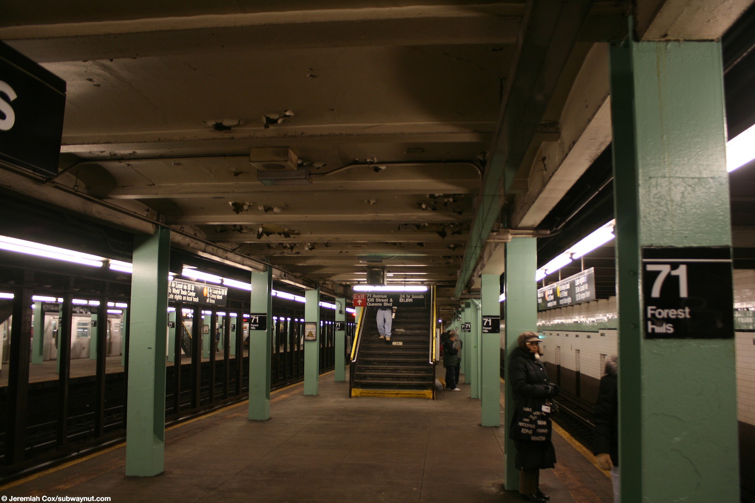
The station has four tracks and two island platforms.[29] The E and F both stop here at all times, running on the express tracks during the day and on the local tracks at night. The R stops here except at night and the M stops here only on weekdays during the day.[30] The M and R both run on the local tracks and the station serves as their northern terminus. The next stop to the west (railroad south) is 67th Avenue for local trains and Jackson Heights–Roosevelt Avenue for express trains. The next stop to the east (railroad north) is 75th Avenue for local E and F trains and Kew Gardens–Union Turnpike for express E trains.[31]
To the east, the line widens to six tracks, with two tracks starting between the local and express tracks in each direction, then ramping down to a lower level, where they widen to four tracks and run under the 75th Avenue station to Jamaica Yard. M and R trains discharge their passengers on the northbound platform and proceed to one of the innermost two tracks to relay and return back southbound to recruit their passengers. F trains during the day and E trains on weekdays during the evening and on weekends during the day switch from the express track to the local track east of the station. This station has four punch boxes: two each at the eastern end and western end.[29]
Both outer track walls have a light Fern green tile band with a black border and small "71st AVE" tile captions below them in white lettering on a black background.[32] The tile band is part of a color-coded tile system used throughout the IND.[33] The tile colors were designed to facilitate navigation for travelers going away from Lower Manhattan. As such, a different tile color is used at Kew Gardens–Union Turnpike, the next express station to the east. The green tiles used at the 71st Avenue station were also used at 75th Avenue, the only local station between 71st Avenue and Union Turnpike.[34][35]

The station's I-beam columns are painted emerald green with signs reading "71 - Forest Hills", while older signs on the black columns between the express tracks read "CONTINENTAL AVENUE - Forest Hills" in black lettering on a white background.[36][37]
Exits[edit]
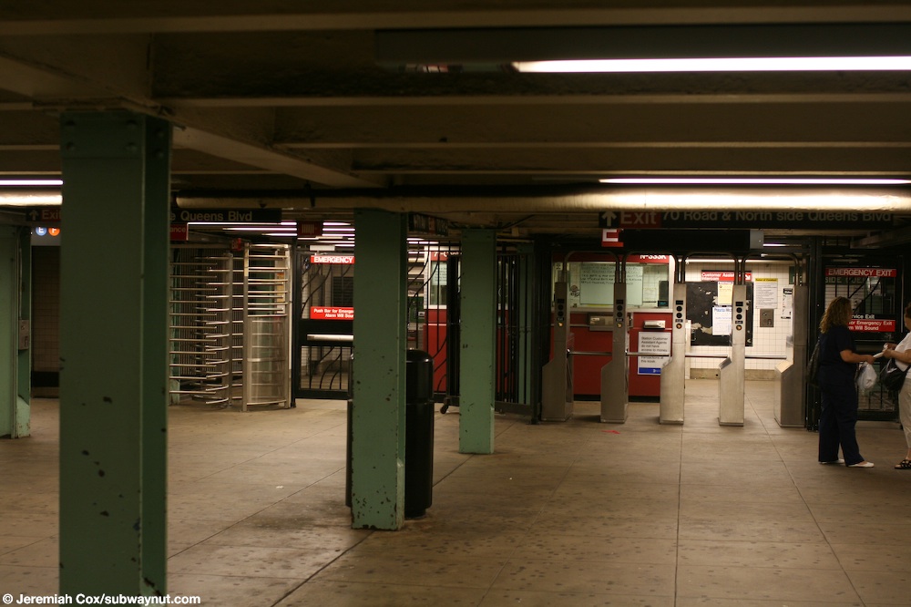
There are two fare control areas on the full width mezzanine above the platforms and tracks. The western section of the mezzanine is bounded on the west by the exit to the western side of 70th Road and the northern side of Queens Boulevard. There used to be a part-time booth at this location. On the east end, the fare control area is sided by a passageway out of fare control connecting the exits between 70th Road and 71st Avenue. There used to be a part-time booth at the northern section of the passageway. An elevator is located at the southern exit between 70th Road and 71st Avenue and makes the station ADA-accessible. The second fare control area is in between the aforementioned fare free passageway and the passageways connecting to the exits at 71st Avenue. At the eastern end of the mezzanine there is a staircase leading to Queens Boulevard between 71st Avenue and 71st Road on the northern side, and a staircase leading to the intersection of 71st Avenue and Queens Boulevard on the south side. There are seven staircases to each platform.[38][39][40]
Signage[edit]
On the current MTA map[41] and published timetables,[42] the station name is "Forest Hills–71st Avenue." In the past, "Continental Avenue" (the alternative name of 71st Avenue used in nearby Forest Hills Gardens) has been included in the name[43] and is used on the rollsigns of older rolling stock such as the R32. As of 2011[update], the platform signage reads 71–Continental Av–Forest Hills.
Points of interest[edit]
Nearby points of interest include:
- Austin Street, a major business thoroughfare in Forest Hills, located south of the station.[39]
- Forest Hills LIRR station, located in Station Square in Forest Hills Gardens at Burns Street.[38][39]
- Ridgewood Savings Bank, Forest Hills Branch, designated a landmark by the New York City Landmarks Preservation Commission since 2000.[44]
- West Side Tennis Club, containing Forest Hills Stadium, which hosted the US Open tennis tournament until 1977.[38][39]
References[edit]
- ^ "Glossary". Second Avenue Subway Supplemental Draft Environmental Impact Statement (SDEIS) (PDF). Vol. 1. Metropolitan Transportation Authority. March 4, 2003. pp. 1–2. Archived from the original (PDF) on February 26, 2021. Retrieved January 1, 2021.
- ^ a b "Annual Subway Ridership (2018–2023)". Metropolitan Transportation Authority. 2023. Retrieved April 20, 2024.
- ^ "Annual Subway Ridership (2018–2023)". Metropolitan Transportation Authority. 2023. Retrieved April 20, 2024.
- ^ a b Duffus, R.L. (September 22, 1929). "Our Great Subway Network Spreads Wider – New Plans of Board of Transportation Involve the Building of More Than One Hundred Miles of Additional Rapid Transit Routes for New York" (PDF). The New York Times. Retrieved August 19, 2015.
- ^ "Queens Subway Work Ahead of Schedule: Completion Will Lead to Big Apartment Building, Says William C. Speers" (PDF). The New York Times. April 7, 1929. Retrieved September 1, 2015.
- ^ a b "Queens Lauded as Best Boro By Chamber Chief". Brooklyn Daily Eagle. September 23, 1929. p. 40. Retrieved October 4, 2015 – via Newspapers.com.
- ^ New York Times, New Subway Routes in Hylan Program to Cost $186,046,000, March 21, 1925, page 1
- ^ a b Hirshon, Nicholas; Romano, Foreword by Ray (January 1, 2013). Forest Hills. Arcadia Publishing. ISBN 9780738597850.
- ^ "Queens to Have 15-Story House – Tall Structure for New Residential Development in Forest Hills Area – Near Boulevard Subway – Several Blocks Rezoned for High Buildings Between Jamaica and Kew Gardens" (PDF). The New York Times. March 23, 1930. ISSN 0362-4331. Retrieved April 26, 2016.
- ^ "Two Subway Links Opened In Queens" (PDF). The New York Times. August 19, 1933. p. 13. ISSN 0362-4331. Retrieved December 11, 2016.
- ^ "Unfinished Sections of Subway Lines To Be Completed" (PDF). The New York Sun. December 13, 1933. p. 47. Retrieved July 30, 2016.
- ^ "Trains Testing Jamaica Link Of City Subway". The Brooklyn Daily Eagle. April 10, 1937. p. 3. Retrieved April 24, 2018.
- ^ "Test Trains Running In Queens Subway; Switch and Signal Equipment of New Independent Line Is Being Checked". The New York Times. December 20, 1936. ISSN 0362-4331. Retrieved April 26, 2016.
- ^ a b Neufeld, Ernest (August 23, 1936). "Men Toil Under Earth to Build Subway" (PDF). Long Island Daily Press. p. 2 (Section 2). Retrieved August 12, 2016.
- ^ See:
- "500 More Quit Subway Work On Boulevard: General Strike Order Issued Today; 72 Walk Out in Jamaica" (PDF). Long Island Daily Press. April 2, 1935. p. 2. Retrieved July 30, 2016.
- "Aldermen Probe Strike on Subway" (PDF). Long Island Daily Press. April 3, 1935. p. 4. Retrieved July 30, 2016.
- ^ "Work Progressing on Queens Subway". The New York Times. August 11, 1935. p. RE2. ISSN 0362-4331. ProQuest 101425888.
- ^ Roger P. Roess; Gene Sansone (August 23, 2012). The Wheels That Drove New York: A History of the New York City Transit System. Springer Science & Business Media. pp. 416–417. ISBN 978-3-642-30484-2.
- ^ "City Subway Opens Queens Link Today; Extension Brings Kew Gardens Within 36 Minutes of 42d St. on Frequent Trains". The New York Times. December 31, 1936. ISSN 0362-4331. Retrieved April 26, 2016.
- ^ "Mayor Takes 2,000 for a Ride ln Queens Subway Extension: Heads Civic Leaders in 10-Car Train Over Route to Kew Gardens That Opens at 7 A. M. Today; Warns of 15-Cent Fare if Unity Plan Fails The Mayor Brings Rapid Transit to Kew Gardens". New York Herald Tribune. December 31, 1936. p. 34. ISSN 1941-0646. ProQuest 1222323973.
- ^ "New Retail Area In Queens Borough; Sees Roosevelt Avenue Subway Station as Great Shopping Centre. Advantages Pointed Out Accessibility to Many Home Communities Assures Potential Market". The New York Times. July 9, 1933. ISSN 0362-4331. Retrieved April 26, 2016.
- ^ "Trains Testing Jamaica Link Of City Subway". The Brooklyn Daily Eagle. April 10, 1937. p. 3. Retrieved April 24, 2018.
- ^ "Jamaica Will Greet Subway" (PDF). The New York Sun. April 23, 1937. p. 8. Retrieved April 24, 2018.
- ^ a b c d Queens Subway Options Study, New York: Environmental Impact Statement. United States Department of Transportation, Metropolitan Transportation Authority, Urban Mass Transit Administration. May 1984. pp. 83–. Retrieved July 10, 2016.
- ^ a b Erlitz, Jeffrey (February 2005). "Tech Talk". New York Division Bulletin. 48 (2). Electric Railroaders Association: 9–11. Retrieved July 10, 2016.
- ^ "Forest Hills Subway Station Project Delayed by Three Months". DNAinfo New York. Archived from the original on February 9, 2014.
- ^ "Forest Hills Subway Station Renovation to End in March, MTA Says". DNAinfo New York. Archived from the original on March 27, 2014.
- ^ "71st Avenue Station Renovation in Forest Hills will Wrap This Month". brownstoner.com. March 25, 2014.
- ^ "Forest Hills-71st Av. ADA Elevators". Flickr. May 9, 2014.
- ^ a b Lynch, Andrew (2020). "New York City Subway Track Map" (PDF). vanshnookenraggen.com. Retrieved February 6, 2020.
- ^ "Subway Service Guide" (PDF). Metropolitan Transportation Authority. September 2019. Retrieved September 22, 2019.
- ^ "Subway Map" (PDF). Metropolitan Transportation Authority. September 2021. Retrieved September 17, 2021.
- ^ Cox, Jeremiah (September 26, 2004). The lime green trim and 71st Ave text underneath it along the platform walls at 71-Continental Av (image).
- ^ "Tile Colors a Guide in the New Subway; Decoration Scheme Changes at Each Express Stop to Tell Riders Where They Are". The New York Times. August 22, 1932. ISSN 0362-4331. Archived from the original on July 1, 2022. Retrieved July 1, 2022.
- ^ Carlson, Jen (February 18, 2016). "Map: These Color Tiles In The Subway System Used To Mean Something". Gothamist. Retrieved May 10, 2023.
- ^ Gleason, Will (February 18, 2016). "The hidden meaning behind the New York subway's colored tiles". Time Out New York. Retrieved May 10, 2023.
- ^ DanTD (March 16, 2017). Continental Avenue-Forest Hills; Old Sign (photograph). Retrieved July 29, 2017.
- ^ Cox, Jeremiah (June 2, 2008). Looking down the Manhattan-bound platform at 71-Forest Hills as the column signs say (image).
- ^ a b c "Subway-Sidewalk Interface Project: 71st/Continental Avenues Station" (PDF). transalt.org. Transportation Alternatives, City of New York, New York City Department of City Planning, New York City Department of Transportation. Archived from the original (PDF) on March 4, 2016. Retrieved September 30, 2015.
- ^ a b c d "MTA Neighborhood Maps: Forest Hills" (PDF). mta.info. Metropolitan Transportation Authority. 2015. Retrieved July 6, 2015.
- ^ Cox, Jeremiah (June 5, 2008). "Looking down the mezzanine towards the 70 Road & North Side Queens Blvd exit at 71-Continental Ave". thesubwaynut.com. Retrieved December 18, 2017.
- ^ "Subway Map" (PDF). Metropolitan Transportation Authority. September 2021. Retrieved September 17, 2021.
- ^ "E Subway Timetable, Effective December 4, 2022". Metropolitan Transportation Authority. Retrieved August 26, 2023.
- ^ "NYC Subway Historical Maps". Retrieved September 27, 2007.
- ^ "Ridgewood Savings Bank, Forest Hills Branch" (PDF). New York City Landmarks Preservation Commission. Retrieved January 27, 2018.
External links[edit]
- nycsubway.org – IND Queens Boulevard Line: 71st/Continental Aves./Forest Hills
- The Subway Nut — 71st Street–Continental Av–Forest Hills Pictures
- 71st Avenue entrance from Google Maps Street View
- Entrance between 71st Avenue and 70th Road from Google Maps Street View
- 70th Road entrance from Google Maps Street View
- Platforms from Google Maps Street View