
Fort Jesus
| UNESCO World Heritage Site | |
|---|---|
 | |
| Criteria | Cultural: ii, v |
| Reference | 1295 |
| Inscription | 2011 (35th Session) |

Fort Jesus (Forte Jesus de Mombaça) is a Portuguese fort built in 1591 by order of King Philip I of Portugal (King Philip II of Spain), then ruler of the joint Portuguese and Spanish Kingdoms, located on Mombasa Island to guard the Old Port of Mombasa, Kenya. It was built in the shape of a man (viewed from the air), and was given the name of Jesus. In 2011, the fort was declared a World Heritage Site by UNESCO, highlighted as one of the most outstanding and well preserved examples of 16th-century Portuguese military fortifications.[1]
Overview
Between 1631 and 1875 the fort was won and lost nine times by the nations contesting control of Kenya. The Omanis took the fort in 1698 after a notable siege of almost three years. It was declared a historical monument in 1958. Today it houses a museum.
The fort was designed by a Milanese architect, Giovanni Battista Cairati, who was the Chief Architect for Portuguese possessions in the East. It was the first European-style fort constructed outside of Europe designed to resist cannon fire.[2] Today, it is one of the finest examples of 16th-century Portuguese military architecture, which has been influenced and changed by both the Omani Arabs and the British.[3] The fort quickly became a vital possession for anyone with the intention of controlling Mombasa Island or the surrounding areas of trade. When the British colonised Kenya, they used it as a prison, until 1958, when they converted it into a historical monument. James Kirkman was then assigned to excavate the monument, which he did (with a large use of external historical documents) from 1958 to 1971.[3]
The architecture of the fort represents the rough outline of a person lying on their back, with the head towards the sea. The height of the walls is 18 meters. The original Portuguese fort had a height of 15 meters, but the much taller Oman Arabs added 3 metres upon capturing the fort.
The fort combines Portuguese, Arab, and British elements; these being the major powers that held it at different times in history. The Portuguese and British presence is preserved in the presence of their respective cannons. The Portuguese cannons had a range of 200 meters and are longer than the British cannons which had a range of 300 meters. Oman Arabs marked their occupancy with numerous Koran inscriptions into the wooden door posts and ceiling beams. The Muslim tradition of 5 pillars is also portrayed throughout the fort, with a former meeting hall supported by five stone pillars to the ceiling.
Some of the historical structures still standing in the fort include Oman House, which was the house for Sultan who governed the East African coast. Others are an open water cistern by the Portuguese for harvesting rain water, and a 76-foot deep well sunk by the Arabs, but whose water was too salty to be used for anything but washing.
The fort was declared a World Heritage site by UNESCO in 2011.
Fort Jesus today
Fort Jesus is now a popular destination for foreign and local tourists. As well as a tourist destination the Fort is important as a host for numerous research programs, a Conservation Lab, and Education Department and an Old Town Conservation Office.
-
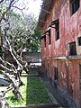
 Building inside the fort
 -
 Windows of the inner buildings
 -
 Juxtaposition of decayed and survived
 -
 Obvious influence of Portuguese architecture


References
- ^ http://whc.unesco.org/en/list/1295
- ^ Gilbert, Erik, and Jonathan T. Reynolds. Africa in World History: From Prehistory to Present. New Jersey: Pearson Education, 2008, p. 225
- ^ a b Kirkman, J. 1974. Fort Jesus: A Portuguese Fortress on the East African Coast Clarendon Press: Oxford