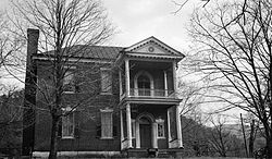
Fotheringay (Elliston, Virginia)
Fotheringay | |
 Fotheringay, HABS Photo | |
| Location | South of the junction of Rtes. 11 and 631, near Elliston, Virginia |
|---|---|
| Coordinates | 37°10′43″N 80°14′36″W / 37.17861°N 80.24333°W |
| Area | 188.1 acres (76.1 ha) |
| Built | c. 1796 |
| NRHP reference No. | 69000262[1] |
| VLR No. | 060-0005 |
| Significant dates | |
| Added to NRHP | November 12, 1969 |
| Designated VLR | May 13, 1969[2] |
Fotheringay is a historic plantation home located near Elliston, Montgomery County, Virginia. The house was built about 1796, and is a two-story, five bay brick dwelling with a hipped roof and deep two-story rear ell. It features a projecting two-level provincial type portico. The house was originally built as a three bay dwelling with the portico on the southernmost bay. It was expanded to the full five bays in the 1950s. It was the home of Col. George Hancock (1754–1820).[3]
It was listed on the National Register of Historic Places in 1969.[1]
References[edit]
- ^ a b "National Register Information System". National Register of Historic Places. National Park Service. July 9, 2010.
- ^ "Virginia Landmarks Register". Virginia Department of Historic Resources. Retrieved 5 June 2013.
- ^ Virginia Historic Landmarks Commission staff (April 1969). "National Register of Historic Places Inventory/Nomination: Fotheringay" (PDF). Virginia Department of Historic Resources. and Accompanying photo
External links[edit]
- Fotheringay, U.S. Route 11 vicinity, Elliston, Montgomery County, VA: 3 photos and 2 data pages at Historic American Buildings Survey
Categories:
- Historic American Buildings Survey in Virginia
- Plantations in Virginia
- Houses on the National Register of Historic Places in Virginia
- Houses completed in 1796
- Houses in Montgomery County, Virginia
- National Register of Historic Places in Montgomery County, Virginia
- Elliston, Virginia
- 1796 establishments in Virginia
- Montgomery County, Virginia Registered Historic Place stubs


