Greater Berlin Act
| History of Berlin |
|---|
 |
| Margraviate of Brandenburg (1157–1806) |
| Kingdom of Prussia (1701–1918) |
| German Empire (1871–1918) |
| Free State of Prussia (1918–1947) |
| Weimar Republic (1919–1933) |
| Nazi Germany (1933–1945) |
| West Germany and East Germany (1945–1990) |
|
| Federal Republic of Germany (1990–present) |
| See also |
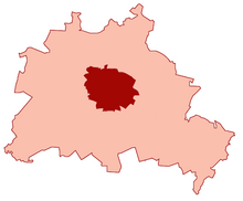
The Greater Berlin Act (Template:Lang-de), officially Law Regarding the Creation of the New Municipality of Berlin (Template:Lang-de), was a law passed by the Prussian state government in 1920, which greatly expanded the size of the Prussian and German capital of Berlin.
History


Berlin had been part of the Province of Brandenburg since 1815. On 1 April 1881, the city became Stadtkreis Berlin, a city district separate from Brandenburg. The Greater Berlin Act was passed by the Prussian Parliament on 27 April 1920 and came into effect on 1 October of the same year.[1] The new Prussian province then termed Greater Berlin acquired territories from the Province of Brandenburg and consisted of the following:
- The city of Berlin (Alt-Berlin);
- 7 towns that surrounded Berlin: Charlottenburg, Köpenick, Lichtenberg, Neukölln/Rixdorf, Schöneberg, Spandau and Wilmersdorf;
- 59 rural communities and 27 estate districts from the surrounding districts of Niederbarnim, Osthavelland and Teltow;
- and the grounds of the Berliner Stadtschloss, which had curiously formed an estate district in its own right.
The Act increased the area of Berlin 13 times from 66 km2 (25 sq mi) to 883 km2 (341 sq mi) and the population doubled from approximately 1.9 million to near 4 million, with almost 1.2 million of the new inhabitants coming from the 7 surrounding towns alone.
Greater Berlin was then subdivided into 20 boroughs (Verwaltungsbezirke):
- from Alt-Berlin: Mitte, Tiergarten, Wedding, Prenzlauer Berg, Kreuzberg and Friedrichshain;
- one borough for each of the 7 previously independent towns: Charlottenburg, Köpenick, Lichtenberg, Neukölln, Schöneberg, Spandau and Wilmersdorf;
- 7 new boroughs created from the remaining added areas, each named after the largest village in the area at the time: Pankow, Reinickendorf, Steglitz, Tempelhof, Treptow, Weißensee and Zehlendorf
Through that law, it became possible to implement integrated town planning across the whole of Greater Berlin. The Act was an important foundation for the rise of Berlin to a cultural centre of Europe in the 1920s.
Apart from minor changes, the city boundary defined in the law is still the same as today even though its character has changed several times over the years. Originally a mere municipal boundary, it became a demarcation line between occupation zones after 1945 and part of the Iron Curtain after 1949, with the Berlin Wall on some of its length between 1961 and 1990. Since the Reunification of Germany, it is the border between the German states of Berlin and Brandenburg.
References
- ^ "1920: A Crisis Year". Unvollendete Metropole. Retrieved 7 September 2021.
External links
- Verfassungen.de, text of the law (in German)
