
Mount Tahan
This article needs additional citations for verification. (May 2014) |
| Mount Tahan | |
|---|---|
| Gunung Tahan ڬونوڠ تاهن | |
 | |
| Highest point | |
| Elevation | 2,187 m (7,175 ft)[1] |
| Prominence | 2,140 m (7,020 ft)[1] |
| Listing | Ultra Ribu |
| Coordinates | 4°37′57″N 102°14′03″E / 4.63250°N 102.23417°E[1] |
| Naming | |
| Native name | Gunung Tahan (Malay) |
| Geography | |
 Mount Tahan Malaysia | |
| Location | Taman Negara Jerantut District, Pahang Gua Musang District, Kelantan |
| Parent range | Tahan Range |
Mount Tahan (Malay: Gunung Tahan), is the highest point in Peninsular Malaysia with an elevation of 7,175 ft (2,187 m) above sea level, on the border between the states of Pahang and Kelantan, with the peak lying on the Pahangese side. It is part of the Taman Negara that straddles Jerantut District in Pahang, Gua Musang District in Kelantan and Hulu Terengganu District in Terengganu. The mountain is part of the Tahan Range in the Tenasserim Hills and is popular with local climbers.
Gunung Tahan is considered by many to be one of the toughest treks in Peninsular Malaysia.
Trails[edit]
There are three trails to the summit, commonly referred to as:
- Kuala Tahan-Kuala Tahan
- Merapoh-Kuala Tahan or Kuala Tahan-Merapoh
- Merapoh-Merapoh
The Kuala Tahan classic trail is the oldest and most scenic trail. A return trip on this trail typically takes seven days. Climbers have to trek across undulating ridges and make several river crossings before finally reaching the foot of the mountain to make the final ascent. Climbers without adequate physical fitness or training are not advised to attempt Gunung Tahan.
The other two trails are from Merapoh (Sungai Relau). The Merapoh-Merapoh trail is significantly shorter than the other two. A return trip on the Merapoh trail takes 3–4 days. A traverse from Kuala Tahan to Merapoh (or the other way around) takes around 5 days.
Temperature[edit]
Mount Tahan can be very cold at night. Temperatures can range from 4 °C to 18 °C between December and January, and 7 °C to 27 °C between June and September. Frost can sometimes appear at the summit.
1905 Expedition by Federated Malay States Museums[edit]
In 1905, the director of the Federated Malay States Museums, Leonard Wray Jnr, and Selangor Museum curator Herbert Robinson led a museum collecting expedition to Gunung Tahan.[2]
The expedition involved sixty-five men and lasted five months.[3] Dato’ To Muntri Idin and Penghulu Panglima Kakap Husin laid the groundwork before the main party arrived.[4][5] On July 15, Bulang, Che Nik, Mat Aris, Mu’min and Robinson were the first to reach the summit[2].
-
 Pulling boats up the rapids in the Tahan river during the 1905 museum expedition to Gunung Tahan.
 -
 Gunung Tahan from sixth camp during the 1905 museum expedition to Gunung Tahan.


-
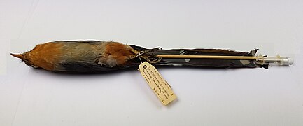
 Bar-throated minla collected during the Federated Malay States Museums expedition to Gunung Tahan.
 -
 Snowy-browed flycatcher collected during the Federated Malay States Museums expedition to Gunung Tahan.
 -
 Red-billed malkoha collected during the Federated Malay States Museums expedition to Gunung Tahan.
_collected_1905-07-19_collected_during_the_Federated_Malay_States_Museums_expedition_to_Gunung_Tahan.jpg)
_collected_1905-07-05_during_the_Federated_Malay_States_Museums_expedition_to_Gunung_Tahan.jpg)
_collected_1905-06-08_during_the_Federated_Malay_States_Museums_expedition_to_Gunung_Tahan.jpg)
Hikers Gallery[edit]
-
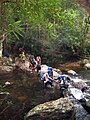 Hikers fording near Kuala Juram
 -
 Sunset near Kem Botak
 -
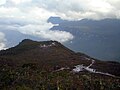
 View at dawn near Kem Botak
 -
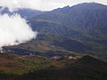
 Unnamed lesser peak, viewed from Kem Botak
 -
 Wooden signboard at the peak. The roof has been torn off due to severe weather in recent years
 -
 Lembah Teku, above Kem Gedung
 -
 Kem Gedung
 -
 Steep descent via a series of metal ladders at Gunung Tangga Lima Belas
 -
 Usnea near the peak
 -
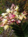 Orchids near the peak
 -
 Rafflesia near Wray's Camp


See also[edit]
References[edit]
- ^ a b c "Southeast Asia: Cambodia, Laos, Thailand, Vietnam and Peninsular Malaysia". Peaklist.org. Retrieved 2014-05-28.
- ^ a b Shaughnessy, Elaine (2020-09-03). "The 1905 ascent of Mount Tahan (Malaysia) and fate of the bird collection". Society for the History of Natural History. Retrieved 2023-03-31.
- ^ Federated Malay States.; States, Federated Malay; Museum, Perak State; Museum, Selangor State (1908). Journal of the Federated Malay States Museums. Vol. 3. Kuala Lumpur: the Museums.
- ^ Xmpsp (2008-05-17). "iNfO LiPaTaN SeJaRaH : xmpsp.com: KONSPIRASI GUNUNG TAHAN". iNfO LiPaTaN SeJaRaH. Retrieved 2023-03-31.
- ^ "RRC: Gunung Tahan trail: some history and background". www.rhinoresourcecenter.com. Retrieved 2023-03-31.