
Hickory Plains, Arkansas
Hickory Plains, Arkansas | |
|---|---|
 Hickory Plains, Arkansas  Hickory Plains, Arkansas | |
| Coordinates: 34°59′24″N 91°44′12″W / 34.99000°N 91.73667°W | |
| Country | United States |
| State | Arkansas |
| County | Prairie |
| Elevation | 249 ft (76 m) |
| Time zone | UTC-6 (Central (CST)) |
| • Summer (DST) | UTC-5 (CDT) |
| ZIP code | 72066 |
| Area code | 870 |
| GNIS feature ID | 57915[1] |
Hickory Plains is an unincorporated community in Prairie County, Arkansas, United States. Hickory Plains is located at the junction of Arkansas highways 13 and 38, 13.5 miles (21.7 km) west of Des Arc. Hickory Plains has a post office with ZIP code 72066.[2]
References[edit]
Municipalities and communities of Prairie County, Arkansas, United States | ||
|---|---|---|
| Cities | 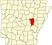 | |
| Towns | ||
| Unincorporated communities | ||
| Footnotes | ‡This populated place also has portions in an adjacent county of counties | |
This article about a location in Prairie County, Arkansas is a stub. You can help Wikipedia by expanding it. |