Hough Peak
| Hough Peak | |
|---|---|
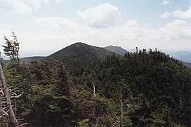
 Hough Peak (center) seen from the ridge to Dix Mt. | |
| Highest point | |
| Elevation | 4,409 ft (1,344 m)[1] |
| Prominence | 374 ft (114 m)[1] |
| Listing | Adirondack High Peaks 23rd |
| Coordinates | 44°04′10″N 73°46′39″W / 44.0694981°N 73.7776352°W[2] |
| Geography | |
| Location | North Hudson, Essex County, New York |
| Parent range | Dix Range |
| Topo map | USGS Mount Marcy |
| Climbing | |
| Easiest route | Dix Range Herd Path |
Hough Peak (/ˈhʌf/) is a mountain located in Essex County, New York. The mountain, part of the Dix Range, is named after Franklin B. Hough (1822–1885), the first chief of the United States Division of Forestry, and sometimes called the "father of American forestry". Hough Peak is flanked to the north by Dix Mountain, and to the south by South Dix.
The east side of Hough Peak drains into the headwaters of the South Fork of the Boquet River, thence into Lake Champlain, which drains into Canada's Richelieu River, the Saint Lawrence River, and into the Gulf of Saint Lawrence. The west side of Hough Peak drains into Lillian Brook, thence into the East Inlet of Elk Lake, and into The Branch of the Schroon River, the Hudson River, and into New York Bay.
Hough Peak is within the Dix Mountain Wilderness Area of Adirondack State Park.
See also[edit]
- List of mountains in New York
- Northeast 111 4,000-footers
- Adirondack High Peaks
- Adirondack Forty-Sixers
Notes[edit]
- ^ a b "Hough Peak, New York". Peakbagger.com. Retrieved 2012-12-18.
- ^ "Hough Peak". Geographic Names Information System. United States Geological Survey, United States Department of the Interior. Retrieved 2012-12-18.
External links[edit]
- "Hough Peak". SummitPost.org.


