
File:Bgiusca Jirecek Line.jpg
No higher resolution available.
Bgiusca_Jirecek_Line.jpg (614 × 561 pixels, file size: 176 KB, MIME type: image/jpeg)
| This is a file from the Wikimedia Commons. Information from its description page there is shown below. Commons is a freely licensed media file repository. You can help. |
| Description |
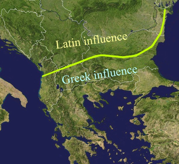
The Jirecek Line, which divides the kind of archaeological findings: to the north of the line most of the inscriptions are in Latin, to the south, they are in Greek. Aegyssos, Argamum, Histria, Tomis & Kallatis cities had greek and latin inscriptions until the VIIth cen. after JC. Jireček claimed that this line represents The division between the Greek and the Latin influence in the Balkans during the Roman Empire |
| Date | |
| Source | Public domain NASA image via worldwind |
| Author | Bogdan Giuşcă |
| Permission (Reusing this file) |
GFDL |

|
Permission is granted to copy, distribute and/or modify this document under the terms of the GNU Free Documentation License, Version 1.2 or any later version published by the Free Software Foundation; with no Invariant Sections, no Front-Cover Texts, and no Back-Cover Texts. A copy of the license is included in the section entitled GNU Free Documentation License. |
| This file is licensed under the Creative Commons Attribution-Share Alike 3.0 Unported license. | ||
| ||
| This licensing tag was added to this file as part of the GFDL licensing update. |
File history
Click on a date/time to view the file as it appeared at that time.
| Date/Time | Thumbnail | Dimensions | User | Comment | |
|---|---|---|---|---|---|
| current | 01:27, 23 February 2022 | | 614 × 561 (176 KB) | Demetrios1993 | The initial version by User:Bogdan had it correct, but later, the western section of the line was altered without any justification. |
| 10:01, 25 March 2018 |  | 614 × 561 (249 KB) | Trecătorul răcit | Antic shoreline and correct present-day borders | |
| 10:50, 7 August 2014 |  | 614 × 561 (250 KB) | Spiridon Ion Cepleanu | According with Jirecek's works and the palaeography of Aegyssos, Argamum, Histria, Tomis & Kallatis cities (greek and latin inscriptions until the VIIth cen. after JC) | |
| 09:56, 19 April 2005 |  | 614 × 561 (101 KB) | Bogdan | The division between the Greek and the Latin influence in the Balkans during the Roman Empire Source: Public domain work {{GFDL}} Category:Romanian historyCategory:Roman Empire\ |
File usage
The following pages on the English Wikipedia use this file (pages on other projects are not listed):
Global file usage
The following other wikis use this file:
- Usage on an.wikipedia.org
- Usage on ar.wikipedia.org
- Usage on ast.wikipedia.org
- Usage on ba.wikipedia.org
- Usage on bg.wikipedia.org
- Usage on ca.wikipedia.org
- Usage on ce.wikipedia.org
- Usage on cs.wikipedia.org
- Usage on cv.wikipedia.org
- Usage on de.wikipedia.org
- Usage on el.wikipedia.org
- Usage on es.wikipedia.org
- Usage on et.wikipedia.org
- Usage on eu.wikipedia.org
- Usage on fa.wikipedia.org
- Usage on fr.wikipedia.org
- Usage on he.wikipedia.org
- Usage on hi.wikipedia.org
- Usage on hr.wikipedia.org
- Usage on id.wikipedia.org
- Usage on it.wikipedia.org
- Usage on ja.wikipedia.org
- Usage on ka.wikipedia.org
- Usage on ko.wikipedia.org
- Usage on la.wikipedia.org
- Usage on lt.wikipedia.org
- Usage on nl.wikipedia.org
- Usage on no.wikipedia.org
View more global usage of this file.