Iset (river)
(Redirected from Iset River)
| Iset | |
|---|---|
 The Iset in Yekaterinburg | |
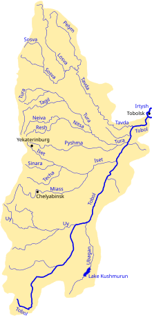
 Iset in the Tobol watershed | |
| Location | |
| Country | Russia |
| Physical characteristics | |
| Source | Lake Iset |
| Mouth | Tobol |
• coordinates | 56°35′55″N 66°17′22″E / 56.59861°N 66.28944°E |
| Length | 606 km (377 mi) |
| Basin size | 58,900 km2 (22,700 sq mi) |
| Discharge | |
| • average | 73.08 m3/s (2,581 cu ft/s) |
| Basin features | |
| Progression | Tobol→ Irtysh→ Ob→ Kara Sea |
| Tributaries | |
| • right | Techa, Miass |
The river Iset (Russian: Исеть) in Russia flows from the Urals through the Sverdlovsk and Kurgan Oblasts, then through Tyumen Oblast in Western Siberia into the river Tobol. The city of Yekaterinburg is on the upper part of the river.[1]
The Iset is 606 kilometres (377 mi) long, and has a drainage basin of 58,900 square kilometres (22,700 sq mi).[1][2][3]
The Techa and the Miass are tributaries of the Iset.[2][3]
References[edit]
- ^ a b I. M. Khokhutkin; et al. (2008). "1. Biodiversity and Ecology of Hydrobionts...". In Raymund I. Veritas (ed.). Biodiversity Research Developments. New York: Nova Science. p. 4. ISBN 9781604562538.
- ^ a b "Река Исеть in the State Water Register of Russia". textual.ru (in Russian).
- ^ a b Olaf M. Johannessen, Vladimir A. Volkov; et al. (2010). "Sources of anthropogenic pollution...". Radioactivity and Pollution in the Nordic Seas and Arctic: Observations . Springer. p. 27. ISBN 9783540498568.
