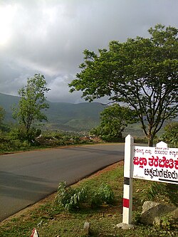
Kaduru
This article needs additional citations for verification. (January 2019) |
Kaduru
Kadur | |
|---|---|
Taluk | |
 Kadur Road | |
| Coordinates: 13°33′12″N 76°00′41″E / 13.553345°N 76.011260°E | |
| Country | |
| State | Karnataka |
| District | Chikkamagaluru |
| Elevation | 763 m (2,503 ft) |
| Population (2011) | |
• Total | 35,834 |
| Languages | |
| • Official | Kannada |
| Time zone | UTC+5:30 (IST) |
| PIN | 577548 |
| Vehicle registration | KA-66 |
Kaduru, also known as Kadur, is a town and a Taluk in Chikkamagaluru district, in Karnataka. It is located at 13°33′12″N 76°00′41″E / 13.553345°N 76.011260°E.[1] located in the rain shadow region of western ghats, most of the taluk is dry unlike much of the district. Kadur is known for Areca nut production.
Demographics
As of 2001[update] India census,[2] Kadur had a population of 35436. Males constitute 51% of the population and females 49%. Kadur has an average literacy rate of 68%, higher than the national average of 59.5%: male literacy is 73%, and female literacy is 63%. In Kadur, 12% of the population is under 6 years of age.
Colleges in Kadur
- Government Pre-University College, B.H Road, Kadur-577548
- Government First Grade College, B.H Road, Kadur-577548
- Kuvempu university PG Center, Gedlehalli, B.H Road, Kadur-577548
Training schools in Kadur
- Police Training School, Gedlehalli, B.H Road, Kadur-577548
- Government Tool Room & Training Center, B.H Road, Kadur-577548
Nearby places
- Ayyanakere Lake: 22 km from Kadur town.
- Madagadakere Lake: 15 km away from Kadur town.
- Hirenalluru : 15 km north east of Kadur, Hirenalluru is known for the Mallikarjuna Temple built in 8th century by Gangas. Later the Hoysala king Ballala II renovated this temple.
- Mullayyanagiri: 67 km west of Kadur, Highest peak in Karnataka With a height of 1,925 metres (6,316 ft).
- Diamond falls: 26 km west of Kadur in Kamenahalli.
Transportation
- 24 hours bus service to Chikkamagaluru, Mangaluru, Dharmasthala, Bengaluru, Hubballi & Mysuru.
- Have limited trains to Shivamogga, Hubballi, Bengaluru, Mysuru, Mangaluru & Chikkamagaluru & No major Inter state Fast Express trains have halt in Kadur Railway station.
- Nearest airports are Mangalore International Airport at 200kms and Kempegowda International Airport, Bengaluru at 230kms.
Roads
- NH-173 to Mangaluru, via Chikkmagalur and Mudigere.
- NH 69 towards Bengaluru & Mysuru, via Banavar
- SH 152 towards Belaguru & Huliyar
- SH 153 towards Hirenalluru & Shivani
Railway
Kadur is a Railway Junction from where trains run in three directions i.e Chikkamagluru, Hubballi & Bengaluru.
References
- ^ Falling Rain Genomics, Inc - Kaduru
- ^ "Census of India 2001: Data from the 2001 Census, including cities, villages and towns (Provisional)". Census Commission of India. Archived from the original on 16 June 2004. Retrieved 1 November 2008.
Transportation
- This article incorporates text from a publication now in the public domain: Chisholm, Hugh, ed. (1911). "Kadur". Encyclopædia Britannica (11th ed.). Cambridge University Press.

