Karlovice (Bruntál District)
Karlovice | |
|---|---|
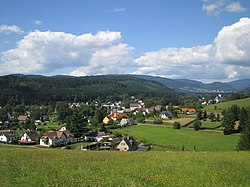
 View of Karlovice | |
| Coordinates: 50°6′20″N 17°26′45″E / 50.10556°N 17.44583°E | |
| Country | |
| Region | Moravian-Silesian |
| District | Bruntál |
| First mentioned | 1558 |
| Area | |
| • Total | 21.63 km2 (8.35 sq mi) |
| Elevation | 480 m (1,570 ft) |
| Population (2023-01-01)[1] | |
| • Total | 1,012 |
| • Density | 47/km2 (120/sq mi) |
| Time zone | UTC+1 (CET) |
| • Summer (DST) | UTC+2 (CEST) |
| Postal code | 793 26 |
| Website | www |
Karlovice (German: Karlsthal) is a municipality and village in Bruntál District in the Moravian-Silesian Region of the Czech Republic. It has about 1,000 inhabitants.
Administrative parts[edit]
The village of Zadní Ves is an administrative part of Karlovice.
Geography[edit]
Karlovice is located about 13 kilometres (8 mi) north of Bruntál and 64 km (40 mi) northeast of Ostrava. It lies on the border between three mountain ranges: Zlatohorská Highlands, Nízký Jeseník and Hrubý Jeseník. Most of the municipal territory lies in the Zlatohorská Highlands. The highest point is near the top of the Větrník mountain at 842 m (2,762 ft) above sea level. The built-up area lies in the valley of the Opava River.
History[edit]
The first written mention of Karlovice is from 1558, then called Hütten. The village was destroyed during the Thirty Years' War and renewed in the 18th century.[2]
During the World War II, the German occupiers operated the E733 forced labour subcamp of the Stalag VIII-B/344 prisoner-of-war camp in the village.[3]
Demographics[edit]
|
|
| ||||||||||||||||||||||||||||||||||||||||||||||||||||||
| Source: Censuses[4][5] | ||||||||||||||||||||||||||||||||||||||||||||||||||||||||
Sights[edit]
The Church of Saint John of Nepomuk was built in the late Baroque style in 1777–1779.[2]
An important technical monument is a former scythe manufactory. It is a timbered two-storey house dating from around 1600, modified to its present form in 1759. Today it houses a local museum that focuses primarily on forestry.[2] The building is protected as a national cultural monument.[6]
Gallery[edit]
-
Church of Saint John of Nepomuk
-
Local museum
References[edit]
- ^ "Population of Municipalities – 1 January 2023". Czech Statistical Office. 2023-05-23.
- ^ a b c "Naše obec" (in Czech). Obec Karlovice. Retrieved 2022-03-15.
- ^ "Working Parties". Lamsdorf.com. Archived from the original on 29 October 2020. Retrieved 3 April 2021.
- ^ "Historický lexikon obcí České republiky 1869–2011 – Okres Krnov" (in Czech). Czech Statistical Office. 2015-12-21. pp. 5–6.
- ^ "Population Census 2021: Population by sex". Public Database. Czech Statistical Office. 2021-03-27.
- ^ "Kosárna" (in Czech). National Heritage Institute. Retrieved 2023-04-18.


