
Lawen, Oregon
Lawen, Oregon | |
|---|---|
 The Old Lawen Store, Highway 78 | |
 Lawen  Lawen | |
| Coordinates: 43°26′35″N 118°48′04″W / 43.44306°N 118.80111°W | |
| Country | United States |
| State | Oregon |
| County | Harney |
| Elevation | 4,108 ft (1,252 m) |
| Time zone | UTC-8 (PST) |
| • Summer (DST) | UTC-7 (PDT) |
| ZIP codes | 97720 |
| Area code | 541 |
| Coordinates and elevation from United States Geological Survey[1] | |
Lawen is an unincorporated community in Harney County, Oregon, United States.[1] It has a post office with a ZIP code 97720.[2] Lawen lies along Oregon Route 78 just south of its interchanges with Oregon Route 205, U.S. Route 20, and U.S. Route 395 in Burns, the county seat. Lawen is just north of the East Fork Silvies River and Malheur Lake.[3]
In 2023 Taylor Perse of the Eugene Weekly described it as "a ghost town with a handful of rundown buildings."[4]
Climate[edit]
According to the Köppen Climate Classification system, Lawen has a semi-arid climate, abbreviated "BSk" on climate maps.[5]
Education[edit]
Lawen is in Harney County School District 4 (Crane School, grades K-8) and Harney County Union High School District 1J (Crane Union High School).[6][7] Crane Union opened in 1918 in Lawen and moved to Crane in 1920.[8]
Harney County is not in a community college district but has a "contract out of district" (COD) with Treasure Valley Community College.[9] TVCC operates the Burns Outreach Center in Burns.[10]
References[edit]
- ^ a b "Lawen". Geographic Names Information System. United States Geological Survey, United States Department of the Interior. November 28, 1980. Retrieved January 3, 2016.
- ^ "Lawen, Oregon". CD Light. 2014. Retrieved January 3, 2016.
- ^ "United States Topographic Map". United States Geological Survey. Retrieved January 3, 2016 – via Acme Mapper.
- ^ Perse, Taylor (August 17, 2023). "School on the Range". Eugene Weekly. Eugene, Oregon. Retrieved March 10, 2024.
- ^ "Lawen, Oregon". Weatherbase. CantyMedia. Retrieved January 3, 2016.
- ^ "2020 CENSUS - SCHOOL DISTRICT REFERENCE MAP: Harney County, OR" (PDF). U.S. Census Bureau. p. 1(PDF p. 2/3). Retrieved March 11, 2024.
Lawen Ln
(use the intersection of Lawen Lane and Steens Highway) - Text list - Compare to the highway map. - ^ "Harney County Sheet 5 of 11" (PDF). Oregon Department of Transportation. Retrieved March 11, 2024. - Lawen indicated on the map. Compare with school district map.
- ^ Flanigan, James (March 1, 1976). "At Crane, they board 'em". The Capital Journal. Salem, Oregon. p. 12. - Clipping from Newspapers.com.
- ^ "Oregon Community Colleges and Community College Districts" (PDF). Oregon Department of Community Colleges & Workforce Development. Retrieved July 17, 2022.
- ^ "Burns Outreach Center". Treasure Valley Community College. Retrieved July 17, 2022.
Municipalities and communities of Harney County, Oregon, United States | ||
|---|---|---|
| Cities | 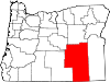 | |
| CDP | ||
| Other communities | ||
| Indian reservation | ||
| Ghost towns | ||
| Desert | ||
This Harney County, Oregon state location article is a stub. You can help Wikipedia by expanding it. |