
Leaman's Place Covered Bridge
Leaman's Place Covered Bridge | |
|---|---|
 | |
| Coordinates | 40°00′43″N 76°06′28″W / 40.0120°N 76.1078°W |
| Locale | Lancaster County, Pennsylvania, United States |
| Official name | Pequea #4 Bridge |
| Characteristics | |
| Design | single span, double Burr arch truss |
| Total length | 113 feet (34.4 m) |
| History | |
| Constructed by | James C. Carpenter |
| Construction start | 1845 |
| Location | |
 | |
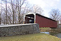
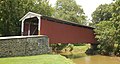
The Leaman's Place Covered Bridge is a covered bridge that spans Pequea Creek in Lancaster County, Pennsylvania, United States. A county-owned and maintained bridge, its official designation is the Pequea #4 Bridge.[1] The bridge is also known as Eshelman's Mill Covered Bridge and Paradise Bridge.
The bridge has a single span, wooden, double Burr arch trusses design with the addition of steel hanger rods. The deck is made from oak planks.[1] It is painted red, the traditional color of Lancaster County covered bridges, on both the inside and outside. Both approaches to the bridge are painted in the traditional white color.
The bridge's WGCB Number is 38-36-20. Added in 1980, it is listed on the National Register of Historic Places as structure number 80003519.[2] It is located on the boundary between Paradise and Leacock townships[3] at 40°0′43.2″N 76°6′28.2″W / 40.012000°N 76.107833°W (40.01200, -76.10783). It is found 0.5 miles (0.80 km) north of U.S. Route 30 on Belmont Road to the west of Paradise.[4][5]
History[edit]
The land that the Leaman's Place Covered Bridge is situated on was settled by the family of Mary Ferree in 1712, a land grant by William Penn in an area inhabited by the Pequaws Indians. It was not until 1845 that James C. Carpenter built the covered bridge across the Pequea Creek at a cost of $933. In 1893,Note: [6] Elias McMellan rebuilt the covered bridge at a cost of $2,431.[3][7] The bridge was rehabilitated in 2004.[4]
Dimensions[edit]
Source:[1]
- Length: 102 feet (31.1 m) span and 113 feet (34 m) total length[3]
- Width: 15 feet (4.6 m) Note:[8]
- Overhead clearance: 11 feet 6 inches (3.51 m)
- Underclearance: 13 feet (4.0 m)
Gallery[edit]
-
-
 Wide side view
 -
 Another Side view
 -
 One of the approaches to the bridge
 -
 The inside of the bridge showing the Burr arch truss


See also[edit]
References[edit]
- ^ a b c "Leaman's Place Covered Bridge". Lancaster County, PA Government Portal. County of Lancaster, Pennsylvania. 2001-10-20. Archived from the original on 2007-09-27. Retrieved 2006-07-07.
- ^ "PENNSYLVANIA - Lancaster County". National Register of Historic Places. Retrieved 2007-03-20.
- ^ a b c Dr. Roger A. McCain. "Leaman Place Bridge". A Guide to Old Covered Bridges of Southeastern Pennsylvania and nearby areas. Archived from the original on 2006-09-07. Retrieved 2006-08-03.
- ^ a b Bickel, Hank (2005-06-23). "Eshelman's Mill / Paradise Bridge". Covered Bridges of the Northeast USA. Retrieved 2006-08-04.
- ^ Travis, Dale. "38-36-20". Round Barns & Covered Bridges. Retrieved 2006-08-08.
- ^ Note: Bickel, McCain, and the Lancaster County Pennsylvania Dutch Country Official Visitors Center list the rebuilt date of 1893. Travis lists a date of 1894.
- ^ "Eshleman's Mill Covered Bridge". Lancaster County Pennsylvania Dutch Country Official Visitors Center. Pennsylvania Dutch Convention & Visitors Bureau. 2006. Retrieved 2006-07-07.
- ^ Note: The official government source lists 15 feet of clear deck width. Both Bickel and McCain list the total width as 15 feet. It is not clear which is correct.

- Covered bridges in Lancaster County, Pennsylvania
- Bridges completed in 1894
- Covered bridges on the National Register of Historic Places in Pennsylvania
- National Register of Historic Places in Lancaster County, Pennsylvania
- Road bridges on the National Register of Historic Places in Pennsylvania
- Wooden bridges in Pennsylvania
- Burr Truss bridges in the United States