Luzino
Luzino | |
|---|---|
Village | |
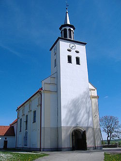
 Saint Lawrence Church | |
| Coordinates: 54°33′46″N 18°6′11″E / 54.56278°N 18.10306°E | |
| Country | |
| Voivodeship | Pomeranian |
| County | Wejherowo |
| Gmina | Luzino |
| Population | 6,985 |
| Time zone | UTC+1 (CET) |
| • Summer (DST) | UTC+2 (CEST) |
| Vehicle registration | GWE |
| Highways | |
| Website | http://www.luzino.pl |
Luzino [luˈʑinɔ] (Template:Lang-csb; formerly Template:Lang-de, (1942-3): Freienau, (1943-5): Lintzau) is a village in Wejherowo County, Pomeranian Voivodeship, in northern Poland. It is the seat of the gmina (administrative district) called Gmina Luzino.[1] It lies approximately 11 kilometres (7 mi) south-west of Wejherowo and 41 km (25 mi) north-west of the regional capital Gdańsk. It is located in the ethnocultural region of Kashubia in the historic region of Pomerania.
The village has a population of 7,560.
History
Luzino was a private church village of the monastery in Żukowo, administratively located in the Puck County in the Pomeranian Voivodeship of the Kingdom of Poland.[2] It was annexed by Prussia in the First Partition of Poland in 1772. Following World War I, Poland regained independence and control of the village.
During the German occupation of Poland (World War II), the occupiers carried out executions of several Poles in the village, as part of the Intelligenzaktion.[3] The local Polish school principal was murdered in November 1939 during the massacres in Piaśnica.[4] In 1940, the occupiers also carried out expulsions of Poles, who were transported to a temporary transit camp in Kartuzy and then deported to the General Government in the more eastern part of German-occupied Poland, while their houses and farms were handed over to German colonists as part of the Lebensraum policy.[5] In 1942, the Germans renamed the village to Freienau, and in 1943 to Lintzau. The German occupation ended in 1945, and the historic name was restored.
References
- ^ "Central Statistical Office (GUS) - TERYT (National Register of Territorial Land Apportionment Journal)" (in Polish). 2008-06-01.
- ^ Biskup, Marian; Tomczak, Andrzej (1955). Mapy województwa pomorskiego w drugiej połowie XVI w. (in Polish). Toruń. p. 103.
{{cite book}}: CS1 maint: location missing publisher (link) - ^ Wardzyńska, Maria (2009). Był rok 1939. Operacja niemieckiej policji bezpieczeństwa w Polsce. Intelligenzaktion (in Polish). Warszawa: IPN. p. 275.
- ^ Wardzyńska (2009), p. 147
- ^ Wardzyńska, Maria (2017). Wysiedlenia ludności polskiej z okupowanych ziem polskich włączonych do III Rzeszy w latach 1939-1945 (in Polish). Warszawa: IPN. pp. 69–70. ISBN 978-83-8098-174-4.


