
Macquarie Island
| UNESCO World Heritage Site | |
|---|---|
 | |
| Criteria | Natural: vii, viii |
| Reference | 629 |
| Inscription | 1997 (21st Session) |
Macquarie Island lies in the southwest corner of the Pacific Ocean, about half-way between Australia and Antarctica. Politically, it has formed part of the Australian state of Tasmania since 1900 and became a Tasmanian State Reserve in 1978. In 1997 it became a world heritage site. It was a part of Esperance Municipality until 1993, when the municipality was merged with other municipalities to Huon Valley.
The Australian Antarctic Division (AAD) maintains a permanent base on the island. The base's residents, the island's only inhabitants, range in numbers from 20 to 40 people throughout the year.
History
The Australian/Briton Frederick Hasselborough discovered the island accidentally in July 1810 when looking for new sealing grounds. He claimed Macquarie Island for Britain and annexed it to the colony of New South Wales in 1810. The island took its name after Colonel Lachlan Macquarie, Governor of New South Wales from 1810 to 1821. Fabian Gottlieb von Bellingshausen, who explored the area for Alexander I of Russia, produced the first map of Macquarie Island. Bellingshausen landed on the island on November 28, 1820, defined its geographical position and traded his rum and food for Macquarie Island's fauna with the sealers.

In 1890 New South Wales transferred the island to Tasmania, which leased it to Joseph Hatch (1837 - 1928) between 1902 and 1920. Between 1911 and 1914, the island became a base for the Australasian Antarctic Expedition under Sir Douglas Mawson. George Ainsworth operated a meteorological station between 1911 and 1913, followed by Harold Power (1913 until 1914) and by Tullock from 1914 until its shutdown in 1915. In 1933 the authorities declared the island a wildlife sanctuary and eventually transferred it to the Commonwealth of Australia under the administration of the Australian Antarctic Territory on December 26, 1947. The Australian National Antarctic Research Expeditions (ANARE) established its expedition headquarters on May 25, 1948 on Macquarie Island.
On December 23, 2004 an earthquake measuring 8.1 on the Richter magnitude scale (one of the largest earthquakes ever recorded) rocked the island, but caused little damage.[1] Some considered this event part of the prelude of earthquakes prior to the 2004 Indian Ocean earthquake, but seismologists have largely discounted this theory.
Vermin infestation
In recent years there have been fears by Antarctic researchers that Macquarie Island is being overrun by rabbits. The rabbits were introduced by sealers in the 1800s as a food source and rapidly multipled before numbers were reduced to about 10,000 in the early 1980s when myxomatosis was introduced. Rabbit numbers have now exploded to around 100,000 on the island.[2]
As well as rabbits there are plagues of rats which together are causing widespread environmental damage. There are currently plans to conduct the largest eradication program ever by mass baiting the island similar to an eradication program on New Zealand's Campbell Island, but there is a argument over which government, state or federal, will pay the estimated $24 million cost.[3]
Geography

The island has an approximate length of 34 km and a width of 5 km, with an area of 128 km². It sits atop Macquarie Ridge, which extends north and south. Also on Macquarie Island are two minor groups of islets, Judge and Clerk Islets, 54°21′S 159°01′E / 54.350°S 159.017°E, 14 km to the north, and 0.2 km² in area, and Bishop and Clerk Islets, 55°03′S 158°46′E / 55.050°S 158.767°E, 34 km to the south, and 0.6 km² in area.
Bishop and Clerk Islets mark the southernmost point of Australia (including islands).
Fauna and flora

Fauna found on the island include: Subantarctic Fur Seals, Antarctic Fur Seals, New Zealand Fur Seals and Southern Elephant Seals - over 80,000 individuals of this species. Royal Penguins breed only on this island; King Penguins, Southern Rockhopper Penguins and Gentoo penguins also breed here. An estimated 100,000 introduced rabbits also occur on the island. Introduced feral cats were declared totally eradicated in 2002.
In September 2006 a large landslip at Lusitania Bay, on the eastern side of the island, partially destroyed an important penguin breeding colony. Tasmania Parks and Wildlife Service attributed the landslip to a combination of heavy spring rains and severe erosion caused by rabbits.[4][3] The Service is seeking funding from the federal or Tasmanian governments for a rabbit eradication plan.
Large portions of the Macquarie Island bluffs are eroding as a result of overeating by rabbits. Rabbits are not indigenous to the island.
Gallery
-
 A Macquarie Island beach
 -
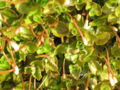 Macquarie Island flora
 -
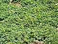 Macquarie Island flora just off the beach


References
- ^ "Antarctic expeditioners unscathed by earthquake". News Online. Australian Broadcasting Commission. 2004-12-24. Retrieved 2007-04-05.
- ^ "Fears for sub-antarctic island plagued by rabbits". News Online. Australian Broadcasting Commission. 2006-07-15. Retrieved 2007-04-05.
- ^ a b Darby, Andrew (2007-04-11). "Up against rats, rabbits and costs". The Sydney Morning Herald. Retrieved 2007-04-11.
- ^ "Rabbits blamed for penguin deaths in landslide". News Online. Australian Broadcasting Commission. 2006-10-21. Retrieved 2007-04-05.
See also
- Administrative Heads of Macquarie Island
- List of islands of Australia
- List of sub-antarctic islands
- List of antarctic and sub-antarctic islands