
Magdiel

Magdiel (Hebrew: מגדיאל) is one of the four original communities of Jewish agriculturalists that combined in 1964 to form Hod Hasharon, Israel. It was founded in 1924 and according to a census conducted in 1931 by the British Mandate authorities had a population of 740.[1]
History[edit]
Before the 20th century, the site of Magdiel formed part of the Forest of Sharon, a hallmark of the region's historical landscape. It was an open woodland dominated by Mount Tabor Oak (Quercus ithaburensis), which extended from Kfar Yona in the north to Ra'anana in the south. The local Arab inhabitants traditionally used the area for pasture, firewood and intermittent cultivation. The intensification of settlement and agriculture in the coastal plain during the 19th century led to deforestation and subsequent environmental degradation known from Hebrew sources.[2]
Magdiel was established as a moshava, starting on 4,000 dunams of land purchased near the Arab village of Biyar 'Adas. The initial population included Jewish immigrants from Russia, Poland and Lithuania, later joined by a group from the Netherlands.[3] In 1964, four villages - Magdiel, Ramatayim, Hadar, and Ramat Hadar - merged to become Hod Hasharon.[4]
The Magdiel Central Synagogue was built between 1930 and 1944, and was inaugurated in an uncompleted stage in 1931. In the run up to independence the synagogue served as a Haganah headquarters.[5] In 2009 a small Haganah weapons cache dating back to the 1948 war was found at the synagogue.[5]

The place name is symbolic Meged El (i.e., the oil of God)"[6] and appears in the Tanach/Old Testament. Magdiel was the name of an Edomite clan (possibly the name of an eponymous chieftain) mentioned in Genesis 36:43. Its invocation of El may show that that deity was worshipped in Edom, along with Kaus and others.
Magdiel is the location of a Youth Aliyah boarding school of that name that took in young survivors of the Holocaust.[7] Other schools there include a comprehensive secondary school and a technical vocational boarding school of the ORT educational network.
-
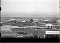 Magdiel 1927
 -
 Magdiel 1927
 -
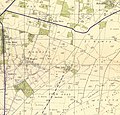 Magdiel 1942 1:20,000
 -
 Magdiel 1945 1:250,000
 -
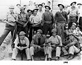 Magdiel soldiers during the 1948 Arab–Israeli War


References[edit]
- ^ Mills, 1932, p. 14
- ^ Marom, Roy (2022-12-01). "יער השרון (אל-ע'אבה) בתקופה העות'מאנית: בתקופה מהמחקר חדשות תובנות הגיאוגרפי-היסטורי The Oak Forest of the Sharon (al-Ghaba) in the Ottoman Period: New Insights from Historical- Geographical Studies". Muse. 5: 90–107.
- ^ Encyclopedia Judaica, Keter Publishing House, Jerusalem, 1972, Vol. 8, p. 802, "Hod Ha-Sharon"
- ^ Encyclopedia Judaica, Keter Publishing House, Jerusalem, 1972, Vol. 8, p. 802, "Hod Ha-Sharon"
- ^ a b Lappin, Yaakov (5 February 2009). "Hagana weapons cache found in Hod Hasharon synagogue". Jerusalem Post. Retrieved 29 November 2023.
- ^ Place names in Israel. A Compendium of Place names in Israel compiled from various sources. Translated from Hebrew, Jerusalem 1962, p.106 (Israel Prime Minister's Office. The Israeli Program for Scientific Translations) (Location of the book: Ben Zvi Institute Library, 12 Abarbanel St., Jerusalem; in the online-catalogue[permanent dead link]
- ^ "NJ Jewish News | Survivor describes escape route through Christianity and back again". Archived from the original on 2007-10-26. Retrieved 2008-08-19.