
Midden-Delfland
Midden-Delfland | |
|---|---|
_2.JPG) Canal through Zweth | |
 Flag Coat of arms | |
.svg) Location in South Holland | |
| Coordinates: 51°59′N 4°19′E / 51.983°N 4.317°E | |
| Country | Netherlands |
| Province | South Holland |
| Established | 1 January 2004[1] |
| Government | |
| • Body | Municipal council |
| • Mayor | Arnoud Rodenburg (CDA) |
| Area | |
| • Total | 49.38 km2 (19.07 sq mi) |
| • Land | 47.19 km2 (18.22 sq mi) |
| • Water | 2.19 km2 (0.85 sq mi) |
| Elevation | −2 m (−7 ft) |
| Population (January 2021)[5] | |
| • Total | 19,414 |
| • Density | 411/km2 (1,060/sq mi) |
| Time zone | UTC+1 (CET) |
| • Summer (DST) | UTC+2 (CEST) |
| Postcode | 2635–2636, 3155 |
| Area code | 010, 015 |
| Website | www |
Midden-Delfland (Dutch: [ˈmɪdə(n)ˈdɛl(ə)flɑnt] ⓘ) is a municipality (gemeente) in the Westland region in the province of South Holland in the Netherlands. It had a population of 19,414 in 2021, and covers an area of 49.38 km2 (19.07 sq mi) of which 2.19 km2 (0.85 sq mi) is water.
It was formed on January 1, 2004, through the merger of the former municipalities:
- Maasland (population: 6,844), covered an area of 24.42 km2 (9.43 sq mi) of which 0.6 km2 (0.23 sq mi) water.
- Schipluiden (population: 11,173), covered an area of 30.00 km2 (11.58 sq mi) of which 0.39 km2 (0.15 sq mi) water.
Population centres[edit]
The municipality comprises the population centres:
Topography[edit]

Dutch topographic map of the municipality of Midden-Delfland, June 2015
Geography[edit]
The green area that comprises the municipality of Midden-Delfland was named Midden-Delfland before 2004, and it referred to the green area surrounded by cities (such as The Hague and Rotterdam) and the horticulture area of Westland. The supporters of a continuous green area were lucky that the municipality of Midden-Delfland became a reality: the cities of Delft, Vlaardingen and Schiedam wanted to build new houses here, and the Westland gardeners also wanted to expand. Now, Midden-Delfland is designated as a recreation area for people from the surrounding cities.
Notable people[edit]
- Jan Vermeer van Utrecht (1630 in Schipluiden – ca. 1696) a Dutch Golden Age painter
- Marja van Bijsterveldt (born 1961) a Dutch politician, Mayor of Delft since 2016
- IJsbrand Chardon (born 1961) a Dutch equestrian and winner at the World Equestrian Games
- Ronald Vuijk (born 1965) a Dutch politician, alderman of Midden-Delfland 2011/2012
- Gerben Moerman (born 1976 in Schipluiden) a Dutch sociologist and academic
Gallery[edit]
-
 Schipluiden - Gaag
 -
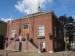 Maasland - Former city hall
 -
 Schipluiden
 -
 Hervormde Kerk Schipluiden
 -
 Hodenpijl, former church
 -
 De Zweth, bridge: Kandelaarsbrug


References[edit]
- ^ "Gemeentelijke indeling op 1 januari 2004" [Municipal divisions on 1 January 2004]. cbs.nl (in Dutch). CBS. Retrieved 13 August 2013.
- ^ "Samenstelling college" [Members of the board] (in Dutch). Gemeente Midden-Delfland. Archived from the original on 7 September 2013. Retrieved 14 August 2013.
- ^ "Kerncijfers wijken en buurten 2020" [Key figures for neighbourhoods 2020]. StatLine (in Dutch). CBS. 24 July 2020. Retrieved 19 September 2020.
- ^ "Postcodetool for 2636HX". Actueel Hoogtebestand Nederland (in Dutch). Het Waterschapshuis. Archived from the original on 21 September 2013. Retrieved 13 August 2013.
- ^ "Bevolkingsontwikkeling; regio per maand" [Population growth; regions per month]. CBS Statline (in Dutch). CBS. 1 January 2021. Retrieved 2 January 2022.
External links[edit]
Places adjacent to Midden-Delfland | |
|---|---|

| International | |
|---|---|
| Other | |