
Namaste Falls
| Namaste Falls | |
|---|---|
 Namaste Falls | |
 | |
 | |
| Location | Bhedetar, Dhankuta, Nepal |
| Coordinates | 26°52′16″N 87°19′48″E / 26.871°N 87.330°E |
| Type | Plunge |
| Total height | 80 average |
| Number of drops | 1 |
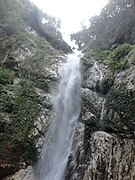
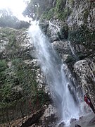
Namaste Falls (Nepali: नमस्ते झरना) is located in Bhedetar village development committee of Dhankuta district. It is popular among domestic tourists. The falls are about 80 meters high.[1] Domestic tourists from Jhapa, Dhankuta, Morang and Sunsari visit this falls in large. One can see a rainbow-like, seven-colour formation while standing close to the waterfall. It is in the shape of Namasthe. The falls are also frequently visited by researchers.[2]
Geography[edit]
It is located 8 km away from Vedatar.[3]
Tourism[edit]
Tourism is common in the area. Along with the falls, Vedatar and Agricultural Research Station on Pakhribas are located nearby. However, there are no human settlements nearby.[4]
Gallery[edit]
-
 A full view of Namaste waterfall
 -
 A full view of Namaste waterfall
 -
 A full view of Namaste waterfall
 -
 A full view of Namaste waterfall
 -
 A full view of Namaste waterfall


.jpg)
See also[edit]
References[edit]
- ^ "Namaste Waterfalls | Namaste Jharna - Khojnu.com". Retrieved 2020-12-08.
- ^ "Namaste Falls". office of distrtrict development committee dhankuta. Archived from the original on 2015-12-24.
- ^ "पूर्वाञ्चलकै मुख्य पर्यटकीय गन्तव्य भेडेटारको नमस्ते झरना Nepalpatra". Retrieved 2020-12-08.
- ^ "पर्यटक लोभ्याउँदै नमस्ते झरना". Thaha Khabar. Retrieved 2020-12-08.
Wikimedia Commons has media related to Namaste Waterfall.