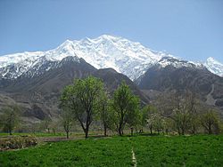
Nasirabad (Hunza)
This article needs additional citations for verification. (March 2020) |
Nasirabad
ناصر آباد | |
|---|---|
Town | |
 The Nasirabad Hunza valley | |
| Coordinates: 36°15′50″N 74°31′33″E / 36.263844°N 74.525956°E | |
| Country | Pakistan |
| Population (2017) | |
| • Total | 6,000 |
Nasirabad (Urdu: ناصر آباد) is a town located in the Hunza District of Gilgit-Baltistan region in Pakistan.
Geography[edit]
Nasirabad is located in Gilgit-Baltistan and bordered to the south by the Hunza River. The Karakoram Highway is the main commercial road, containing multiple businesses including hotels, hostels, cafes, and stores.
Former names[edit]
Nasirabad was known as Hayul Dass during the Rono age. It was later known as Manishmal, a Hindi word for "a fertile place with great prosperity". Later still it was known as "Hini", derived from "Hin", which means "snow" in the Shina language.[1]
History[edit]
The earliest known history of Nasirabad dates back to the Rono people, who flourished across the Hunza region. The Rono emerged and flourished before the early-16th-century arrival of the forefathers of the current tribes in the settlement, such as the Tartay and Doodiye.[1]
Gallery[edit]
-
Nasirabad
-
Nasirabad
-
Nasirabad
References[edit]


