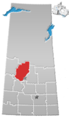
Division No. 16, Saskatchewan
Division No. 16 | |
|---|---|
| Country | |
| Province | |
| Area | |
• Total | 21,828.49 km2 (8,428.03 sq mi) |
| As of 2016 | |
| Population (2016) | |
• Total | 37,999 |
| • Density | 1.7/km2 (4.5/sq mi) |
Division No. 16 is one of eighteen census divisions in the province of Saskatchewan, Canada, as defined by Statistics Canada. It is located in the north-central part of the province. The most populous community in this division is North Battleford.
Demographics
[edit]In the 2021 Census of Population conducted by Statistics Canada, Division No. 16 had a population of 37,993 living in 14,886 of its 19,000 total private dwellings, a change of -0% from its 2016 population of 37,999. With a land area of 21,607.42 km2 (8,342.67 sq mi), it had a population density of 1.8/km2 (4.6/sq mi) in 2021.[1]
Census subdivisions
[edit]The following census subdivisions (municipalities or municipal equivalents) are located within Saskatchewan's Division No. 16.
Cities
[edit]Towns
[edit]Villages
[edit]Resort villages
[edit]Rural municipalities
[edit]Crown colonies
[edit]Unorganized areas
[edit]Indian reserves
[edit]- Indian Reserve --Ahtahkakoop 104
- Indian Reserve --Big River 118
- Indian Reserve --Chitek Lake 191
- Indian Reserve --Little Red River 106D
- Indian Reserve --Lucky Man
- Indian Reserve --Mistawasis 103
- Indian Reserve --Muskeg Lake 102B
- Indian Reserve --Muskeg Lake 102D
- Indian Reserve --Muskeg Lake 102E
- Indian Reserve --Muskeg Lake 102F
- Indian Reserve --Muskeg Lake 102G
- Indian Reserve --Muskeg Lake Cree Nation 102
- Indian Reserve --Pelican Lake 191A
- Indian Reserve --Pelican Lake 191B
- Indian Reserve --Saulteaux 159A
- Indian Reserve --Sturgeon Lake 101
- Indian Reserve --Sweet Grass 113-L6
- Indian Reserve --Witchekan Lake 117
- Indian Reserve --Witchekan Lake 117D
See also
[edit]References
[edit]- ^ "Population and dwelling counts: Canada and census divisions". Statistics Canada. 9 February 2022. Retrieved 2 April 2022.
- ^ a b Statistics Canada. 2002 2001 Community Profiles. Archived 2005-12-22 at the Wayback Machine Released June 27, 2002. Last modified: 2005-11-30. Statistics Canada Catalogue no. 93F0053XIE. Page accessed January 5, 2007
- Division No. 16, Saskatchewan[permanent dead link] Statistics Canada
52°27′42″N 107°23′35″W / 52.46167°N 107.39306°W


