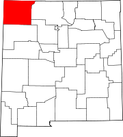
North Light Plant, New Mexico
Appearance
North Light Plant, New Mexico | |
|---|---|
| Coordinates: 36°52′31″N 108°02′45″W / 36.87528°N 108.04583°W | |
| Country | United States |
| State | New Mexico |
| County | San Juan |
| Area | |
• Total | 2.16 sq mi (5.60 km2) |
| • Land | 2.16 sq mi (5.60 km2) |
| • Water | 0.00 sq mi (0.00 km2) |
| Elevation | 5,961 ft (1,817 m) |
| Population | |
• Total | 556 |
| • Density | 257.17/sq mi (99.30/km2) |
| Time zone | UTC-7 (Mountain (MST)) |
| • Summer (DST) | UTC-6 (MDT) |
| Area code | 505 |
| GNIS feature ID | 2584166[3] |
North Light Plant is an unincorporated community and census-designated place in San Juan County, New Mexico, United States. Its population was 414 as of the 2010 census.[4] New Mexico State Road 574 passes through the community.
Geography
North Light Plant is located at 36°52′31″N 108°02′45″W / 36.8751714°N 108.0458434°W.[3] According to the U.S. Census Bureau, the community has an area of 0.694 square miles (1.80 km2), all land.[4]
Demographics
| Census | Pop. | Note | %± |
|---|---|---|---|
| 2020 | 556 | — | |
| U.S. Decennial Census[5][2] | |||
Education
It is divided between Aztec Municipal Schools (the majority) and Farmington Municipal Schools (a minority section).[6] Aztec High School is the local high school of the former.
References
- ^ "ArcGIS REST Services Directory". United States Census Bureau. Retrieved October 12, 2022.
- ^ a b "Census Population API". United States Census Bureau. Retrieved Oct 12, 2022.
- ^ a b "North Light Plant Census Designated Place". Geographic Names Information System. United States Geological Survey, United States Department of the Interior.
- ^ a b "2010 Census Gazetteer Files - Places: New Mexico". U.S. Census Bureau. Retrieved December 21, 2016.
- ^ "Census of Population and Housing". Census.gov. Retrieved June 4, 2016.
- ^ "2020 CENSUS - SCHOOL DISTRICT REFERENCE MAP: San Juan County, NM" (PDF). U.S. Census Bureau. Retrieved 2022-07-12.


