
North Square (Boston, Massachusetts)

North Square in the North End of Boston, Massachusetts, USA, sits at the intersection of Moon, Prince, North, Garden Court and Sun Court Streets. Paul Revere lived here, as did other notables in the 17th and 18th centuries. Prior to July 4, 1788, the area was known as Clark's Square.[1]
History[edit]
In the 17th century, Old North Meeting House anchored the neighborhood. Its pastor, Increase Mather, lived in the square "until the great fire of 1677, when his residence was destroyed".[2]
"In the eighteenth century Boston's two grandest houses were on North Square. ... William Clark, merchant, had a 3-story brick house with 26 lavish rooms, and nearby, facing the garden court, was John Foster's house, later occupied by Governor Hutchinson."[3] John Pitcairn and John Downes also lived in the square.[4]
As was typical of the North End generally, in the 20th century predominantly Italian immigrants lived in the square. Since the 1950s, it has been part of the Freedom Trail.
Image gallery[edit]
-
![Foster-Hutchinson house, corner of Garden Court and Fleet St. Probably built ca.1686 by merchant John Foster. Occupied by merchant Thomas Hutchinson (d.1739) (father of Governor Hutchinson, who was born in the house)[5]](//upload.wikimedia.org/wikipedia/commons/thumb/2/2c/Foster_Hutchinson_house_FleetSt_Boston.png/273px-Foster_Hutchinson_house_FleetSt_Boston.png) Foster-Hutchinson house, corner of Garden Court and Fleet St. Probably built ca.1686 by merchant John Foster. Occupied by merchant Thomas Hutchinson (d.1739) (father of Governor Hutchinson, who was born in the house)[5]
Foster-Hutchinson house, corner of Garden Court and Fleet St. Probably built ca.1686 by merchant John Foster. Occupied by merchant Thomas Hutchinson (d.1739) (father of Governor Hutchinson, who was born in the house)[5] -
 Detail of 1743 map of Boston, showing North End and Clark's Square (later North Square)
 -
 Detail of 1814 map of Boston, showing North Square
 -
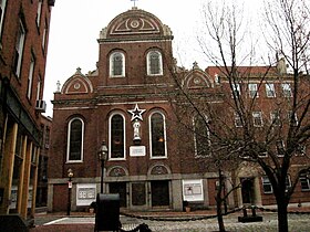
![Bethel Church, built 1832[6]](//upload.wikimedia.org/wikipedia/commons/thumb/4/4c/BethelChurch_NorthSq_Bowen_PictureOfBoston_1838.png/130px-BethelChurch_NorthSq_Bowen_PictureOfBoston_1838.png) Bethel Church, built 1832[6]
Bethel Church, built 1832[6] -
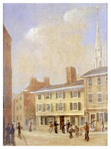 North Square, ca.1845, by Rupert Sadler
 -
 North Square and North Street, ca.1894
 -
 North Sq., ca.1895
 -
 North Sq., 2010
![Foster-Hutchinson house, corner of Garden Court and Fleet St. Probably built ca.1686 by merchant John Foster. Occupied by merchant Thomas Hutchinson (d.1739) (father of Governor Hutchinson, who was born in the house)[5]](/wiki/File:Foster_Hutchinson_house_FleetSt_Boston.png)


![Bethel Church, built 1832[6]](/wiki/File:BethelChurch_NorthSq_Bowen_PictureOfBoston_1838.png)


See also[edit]
References[edit]
- ^ http://www.cityofboston.gov/publicworks/streetbook
- Boston Street Laying-Out Dept. A record of the streets, alleys, places, etc. in the city of Boston. Boston: City Printing Dept., 1910. - ^ Mann, ed. Walks & talks about historic Boston. Boston: Mann Publishing Co., 1916; p.45.
- ^ Southworth and Southworth. AIA Guide to Boston, 3rd ed. Globe Pequot, 2008; p.63.
- Lydia Maria Child describes Hutchinson's house in her 1826 novel The Rebels, or Boston before the Revolution. Cf. F. Carruth. Boston in Fiction. The Bookman, November 1901; p.243. - ^ "The Clark and Hutchinson Houses". Proceedings of the Massachusetts Historical Society, Vol. 18, 1881; p.345.
- ^ A. W. Mann. Walks & Talks About Historic Boston. 1917
- ^ Bowen's picture of Boston. 1838.
External links[edit]
- Bostonian Society Archived 2010-05-09 at the Wayback Machine has materials related to the square.
- Google news archive
