
Pecos River
The Pecos River or Rio Pecos, as it is sometimes known in New Mexico, arises near Pecos, New Mexico, United States, and flows for 926 miles (1,490 km) through the eastern portion of that state and neighboring Texas before it empties into the Rio Grande near Del Rio. The river drains approximately 44,300 square miles (115,000 km2) of land.[1]
The river is dammed at Avalon and McMillan, New Mexico to help irrigate about 25,000 acres (10,000 ha) as part of the Carlsbad reclamation project (established in 1906). Texas has also dammed the river at the Red Bluff Dam in the western part of that state to form the Red Bluff Reservoir. The portion of the reservoir that extends into New Mexico forms the lowest point in that state. New Mexico and Texas disputed water rights to the river until the federal government settled the dispute in 1949.
The river played a large role in the exploration of Texas by the Spaniards. In the latter half of the 19th century, "West of the Pecos" was a reference to the rugged frontiers of the Wild West.
Wild and Scenic River
On June 6, 1990, 20.5 miles (33 km) of the Pecos River - from its headwaters to the townsite of Terrerro - received National Wild and Scenic River designation. 13.5 miles (22 km) are designated "wild" and 7 miles (11 km) are designated "recreational."[2]
-
 Sluggish flow of the Pecos River near Villanueva, New Mexico.
 -
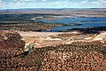 Santa Rosa Lake and Dam on the Pecos River in Guadalupe County, New Mexico.
 -
 Pecos River near the Rio Grande.
 -
 Pecos River below Terrerro and above Pecos, New Mexico.


References
- ^ Largest Rivers of the United States, USGS
- ^ Pecos Wild and Scenic River, New Mexico - National Wild and Scenic Rivers System
See also
- List of New Mexico rivers
- List of Texas rivers
- List of National Wild and Scenic Rivers
- USS Pecos (AO-6) — a fleet oiler built in 1921.
- USS Pecos (AO-65) — a fleet oiler built in 1942.
- USNS Pecos (T-AO-197) — an underway replenishment oiler built in 1990.
External links
- Pecos River from the Handbook of Texas Online