
Port Dalhousie: Difference between revisions
No edit summary |
|||
| Line 196: | Line 196: | ||
==External links== |
==External links== |
||
*[http://www. |
*[http://www.peer2000.com/ Dalhousie Peer Magazine] |
||
*[http://www.portdalhousie.com/ Port Dalhousie Official BIA website] |
*[http://www.portdalhousie.com/ Port Dalhousie Official BIA website] |
||
*[http://www.tourstcatharines.com/tours-portdalhousie.shtml Port Dalhousie walking tour] |
*[http://www.tourstcatharines.com/tours-portdalhousie.shtml Port Dalhousie walking tour] |
||
Revision as of 14:36, 25 January 2008

Port Dalhousie is a community in St. Catharines, Ontario, Canada. It is known for its cultural heritage. It is home to the Royal Canadian Henley Regatta and is historically significant as the terminus for the first three (19th century) routes of the Welland Canal.
The city's most popular beach, on the shore of Lake Ontario, is located in Port Dalhousie at historic Lakeside Park. The park is home to an antique Carousel which was carved by Charles I. D. Looff in 1905 and brought to St. Catharines in 1921. It continues to provide amusement for young and old alike, at just 5 cents a ride.
Port Dalhousie owes its existence and growth to the building of the First Welland Canal, begun in 1824 and completed in 1829. The entrance to the first canal was at the west end of the present Lakeside Park and followed along the bank, on the northeast side of Lock Street then turning south and passing behind the former Government Gate Yard and Maple Leaf Rubber Company (Lincoln Fabrics) before linking up with the Twelve Mile Creek.
The locks of this canal were very small, being only 100 feet long and 20 feet wide, built of wood. Traffic at the time was carried on small sailing vessels, having a carrying capacity of between five and six thousand bushels of grain.
Along with the canal came the people to serve its needs. Barge and horse handlers, tow boys, ships chandlers, and dry dock workers. Rooming houses and grog shops flourished bringing a different life and flavour to what had been a sparsely populated rural farming area.
Prior to the arrival of the Europeans, the area at the mouth of what we now call the Twelve Mile Creek, was a fertile marshy area teeming with fish and wildlife and inhabited by the Neutral Indians. They built their villages and hunted in the interior wilderness, creating trails and clearing forests. Their diet consisted of corn, beans, squash, fish and meat.
In 1650 these Indians, who had avoided conflict with the Huron tribes to the north and the Iroquois in the east, were annihilated by the Iroquois who had just defeated the Hurons. Soon after, the Mississaugas, a branch of the Chippawa tribe, settled in this area and further developed trails which would be used by the French who followed. Throughout the years, arrowheads from these early tribes have been uncovered in McMahon's farm, on Read Island and in other areas of Port Dalhousie.
The first families to settle around the Twelve Mile Creek lakefront entrance and shoreline were the United Empire Loyalists. These former American Colonists had remained loyal to Britain during the American Revolution. Many had fought with the Butler's Rangers against the American Revolutionaries and when the war was over they disbanded in Niagara in 1783. For their efforts, loyalty and their losses of land, possessions and livelihood they were given grants of Crown land as compensation.
One such United Empire Loyalist was Captain Peter Tenbroeck, an officer in Butler's Rangers, who re-entered civilian life with hundreds of others when Butler's Rangers were disbanded at Niagara. In 1796 he received over eight hundred acres of Crown land. The land which Port Dalhousie was later built on was listed in the Crown grants in the name of Captain Tenbroeck.
Benjamin Pawling, also a Butler's Ranger, received a large tract of land in the township of Grantham just east of Port Dalhousie. He and his brother Jesse were sons of a Welshman who settled in Pennsylvania before the American Revolutionary War. Later Jesse married Captain Tenbroeck's daughter, Gertrude, and they had several children.
On December 28, 1821, Jacob Tenbroeck, son of Captain Peter Tenbroeck, sold to Henry Pawling, son of Jesse and Gertrude, three hundred acres of land now in Port Dalhousie. On the same day Henry Pawling deeded the land to his younger brother (Squire) Nathan Pawling. Both Gertrude and Jesse were dead, as well as Benjamin, leaving Henry heir-at-law. With the speculations of improved communications between Lakes Erie and Ontario, it's possible that Jacob was ensuring that the Pawlings had the land deed of the area.
Peter Tenbroeck and Benjamin Pawling also served as judges and members of the Land Board from 1789 to 1791. Benjamin Pawling was then elected to the first Parliament of Upper Canada in 1792. Thos. Merritt, another early settler, served as Sheriff from 1803 to 1820. These men, and their families, took up land on both sides of the Twelve Mile Creek. Other settlers included the families of Adam Bowman, William May, the Coles and the Schrams.
The settlement was called 'Dalhousie' as early as 1826. It was not yet a port and was named after the Earl of Dalhousie, who was governor-general of Canada from 1820-1828.
This was General George Ramsay, 9th Earl of Dalhousie, his ancestral home was Dalhousie Castle in Midlothian, Scotland. He was first appointed Governor of Nova Scotia from 1816 to 1820, then Governor General of British North America from 1820 to 1828 and later Commander-in-Chief in India.
While serving as Lieutenant-Governor of Nova Scotia he founded Dalhousie University in Halifax, Nova Scotia.
The early settlers who arrived were faced with many hardships and met with much misfortune in attempting to clear and cultivate the land, build homes for their families and establish businesses. It was a constant battle filled with tragedy and suffering, often resulting in the loss and abandonment of hope. The severe drought of 1818; the increases in population upon completion of each canal and the resulting poverty and starvation; the depression in the early 1830's and 1840's and the Irish feuds and raids contributed to the drudgery and misery of settlement life. Their lot was difficult and bitter, and it was a struggle merely to stay alive.
The early roads followed Indian trails one of which paralleled the lakeshore from Old Niagara to the Burlington inlet. Each creek along the way had to be ferried. Today, lake erosion has destroyed much of this road.
NOTE: As a young boy I can remember travelling out Lakeshore Road to "Fifteen Beach" and going down the hill, to the lake, just past Gregory Road. My Grandmother had a friend, Mrs. Buchanan, from Brantford, who owned a beautiful summer home right on the beach.
The opening of the First Welland Canal caused a migration to the area of a canal labour force, as well as industry and services to meet the needs of the growing settlement. Most of the men who had come to work on the canal were fortunate enough to establish themselves in the settlement, some on canal and bank maintenance, and others on canal concerns and businesses.
One industry which developed was shipbuilding. The abundant growth of virgin timber at the water's edge and the proximity to the canal directly resulted in the birth and flourishment of this enterprise in Port Dalhousie and St. Catharines.
In 1837 Robert Abbey, a Scotsman whose trade was boat building, established a shipyard at Port Dalhousie, building yawls, sailing yachts and steam yachts. In 1839 Alexander Muir came to the Twelve Mile Creek entrance to set up a Dry Dock. By 1860 another shipyard, Donaldson, Andrews and Ross had been established in Port Dalhousie.
On a return trip from sailing to Port Dalhousie, Muir bought ten acres of land on Queen Street (now Dalhousie Avenue) for sixty dollars and built a house on it. He did not settle there at that time, rather preferring to further sail the lakes.
At that time there were 14 houses in the settlement. Those early settlers names were Pawling, Woodall, Wood, Brown, Abbey, Alexander, Read, Ingster, Irvine, Smiley, McGrath, Neilon, Sullivan, Bruce and Col. Clark. Squire Pawling acted as magistrate. school teacher, farmer, postmaster and storekeeper.
The Muir Bros; Alexander, Bryce, David, and Archibald arrived from Ayshire in 1835. By 1840, Alexander had built the first Dry Dock, a sort of wooden box on the creek bottom, with a gate at one end. By 1855, they had a real Dry Dock and were building ships. All the names of the ships began with an "A" - Ayr, Advance, Ark, Albatross, Albacore, Antelope, Acorn, Asia, August and Artik.
In 1842 the first steam vessel travelled through the Welland Canal and traffic began to grow.There was one group who inevitably would suffer considerable losses as a result of this—the tow teams.
Towing of boats was an important factor of canal navigation. As the barges, sloops, scows and schooners had no power with which to propel themselves, they relied heavily on this service, there were, at the time, one hundred and fifty teams of horses stabled at the west end of Lakeside Park. With the advent of steamships and tugs for towing purposes, the use of the horse and oxen teams at Port Dalhousie and other points along the canal was on the wane. The towmen obviously objected strongly to the use of steam tugs for towing. Although their decline was gradual, they ultimately met their demise during the period of the third Welland Canal.
It is widely believed that the tow teams are responsible for the designation of the east bank of the canal as the 'Michigan Side'. As the nature of their employment was seasonal, the tow boys and teams were jobless when the canal froze and shipping had stopped for the winter. At that time he teamsters transported their men and teams by rail to Michigan where they were engaged to cut and haul timber. In the spring these men returned to Port Dalhousie to resume their business and settled on the east side of the canal which was then termed the 'Michigan Side'
Port Continues to Grow
With the building of the Second Canal, John Lawrie built a grist and flour mill in an area which is really an island situated between Lock One of the First and Second Canal and Lock One of the Third Canal.. The mill was later sold to Mr. Neelon, then it burned down.
The first cluster of buildings naturally developed close to the canal along Front Street and up Lock Street. At the corner of Front and Lock was the Wood House, originally owned by Sam Cole. Next door was a General Store, owned by Richard Wood. Opposite the Wood House was a feed store, while in the "grand basin" Alexander Muir built his Dry Dock and Shipyard.
Nathan Pawling built many stores and buildings. He built one store and Post Office at the corner of Dalhousie Avenue and Lock Street and another store at the corner of Main and Brock Streets.
Thos. Read built a large rooming house at the corner of Main and Simcoe Streets to house the canal workers. The Government erected a brick building on Lock Street for Customs and other officials. This brick building is still in use as an apartment building. It was my first home in Port in 1946.
At the time of the opening of the Second Canal, Port Dalhousie was a growing settlement. It was portrayed in 1846 as "a small village on the [west] side of the canal, in the north west corner of the township of Grantham, five miles from St.Catharines, where is a shipyard. Port Dalhousie contains two hundred inhabitants, two stores, one tavern, and two blacksmith".
A grain elevator was built for storing grain from lightered ships when the Second Welland Canal was built in 1842-1845. Literally thousands of ships used the Welland Canal system. Lock One, of the second Welland Canal, was at the foot of the hill on Front Street (lakeport Road). What remains of the lock is still visible today.
Front Street was known as "Tavern Strand" because there were 17 grog shops located on the street and up Lock Street. Beside the Wood House there were three other hotels; Runcey's, Walkerley's and one owned by a coloured person "Lancaster" whose hotel was reportedly a gathering place for bounty hunters during the U.S. Civil War.
By the early 1850's it became clear that the size of the canal was not large enough to handle the size of the newer vessels. In an effort to avoid the high costs of rebuilding, a decision was made to construct a railway connecting the two canal terminal points to assist in the transfer of grain and other products between steamships operating on both lakes. In addition, some winter traffic would be possible after the canal had frozen. Consequently, in 1853 the Port Dalhousie & Thorold Railway Company was chartered with authority to build a line between Port Dalhousie and Port Colborne.
A Large elevator was built to handle grain which had previously been lightered in scows. The railway was connected to the Michigan Central Railway and that is how the east side was called the Michigan side. However, the local version of how Michigan Side got its name is somewhat different.
In the early days, the flow of water down the Twelve Mile Creek from the escarpment was not nearly as strong as it is today. The present current is caused by the increased flow of water through the Decew Power Station. Until this happened, Martindale Pond was a quiet, calm and shallow body of slowly moving water which froze over early in November. As a consequence shipping halted by late October and forced many ships to tie-up in the lower harbour.
The Railway expands.
In 1859 the railway line was extended to Port Colborne and the name was changed to the Welland Railway. Later it was acquired by the Grand Trunk system which finally became part of the (CNR) Canadian National Railway. The railway was not built for the convenience of passengers but to augment the revenue of the canal. Grain could be off-loaded and stored and shipped between elevators at either end. This increased the speed with which the grain could be shipped between Lakes Ontario and Erie. It also compensated for the size and limited draught of the small sailing ships.
The Thorold-Port Dalhousie railway line was constructed in 1853 with its northern terminal located on the east side of the canal. In 1859 the name was changed to the Welland Railway and an extension was made to Port Colborne. A foot bridge was later constructed from Port Dalhousie to the Welland Railway, a convenience to pedestrians wanting to catch the train.
Large grain elevators were built at both ends. As the canal was not very deep some of the vessels had to be lightened to ensure passage. Some of those vessels were heavy laden and had to be lightened at Port Colborne by taking off part of their cargo and shipping them down on the railroad.
Village becomes Incorporated
With the population steadily increasing, it was decide to incorporate as a village. Applications had been made to the County Council and on October 30, 1862 a bylaw was passed "To Incorporate the Village of Port Dalhousie". A vote was taken and the following were elected as the first council: John Lawrie, reeve, Alexander Muir, Owen McMahon, Nathan Pawling and Richard Wood, councillors; John Hindson, clerk.
In 1876 "EMPRESS OF INDIA" the provided regular passenger service between Toronto and Port Dalhousie.The village seems to have been called Port Dalhousie as early as 1842.The village was known mainly as a turning place for the canal crews. Its one principal street facing the canal basin had houses on one side only, mostly taverns, with or without a license, plus a few supply stores. Its inhabitants were a collection of sailors and towing gangs waiting for another job.
But alongside the rough and ready side of life that the canal brought, this same scattered and rural community was concerned with the responsibilities of a community. This included churches and schools.
The Town continues to grow and expand in many ways.
As the settlement steadily grew, there arose certain community needs, which had to be met.
As for churches in the early days, travelling missionaries held services in a log schoolhouse in the west end of Port Dalhousie near the land dedicated as St. John's Cemetery. The Anglican parish of St. James Louth was founded in 1834 and the first church was built in 1841 on land donated by Thomas and George Read. The name was changed to St. John's in 1868 when the present brick building on Main Street was constructed. The following year the original wood structure was moved by scow up the canal to Merritton where in 1892 it was destroyed by fire.
Around the same time, the Presbyterian parish of Port Dalhousie was forming, holding services at the log schoolhouse. In 1849, Nathan Pawling donated land for a church and burying ground, as well as promising financial support. A few years later a frame building was constructed on Church Street and opened for worship. The present St. Andrew's church and Sunday school were constructed in 1894. On June 10, 1925 the church decided to join with the Methodists, Presbyterians and the Congregationalists to form the United Church of Canada.
The Star of the Sea church was built in 1871 on land purchased from Owen McMahon. It was made of stone which was brought here from Kingston as ballast. The stones were dropped off at Lock One and Catholics and Protestants joined in a common cause. Anyone passing the pile felt obligated to load their wagons and buggies and carry the stones to the church site. Mention is made of a structure used as a church prior to this. Legend has it that a group of sailors caught in a sudden violent lake storm promised in prayer that they would build a church when they safely arrived ashore. Their prayers were answered and their promise kept when they landed in Port Dalhousie. The original steeple was built tall enough to be seen from the middle of the lake, a navigational aid to other vessels. It was blown over in a storm around 1928.
The first schoolhouse, constructed of logs, was situated in the west part of the village on what used to be the Corbett farm. It was replaced by one on Dalhousie Avenue near Gertrude and then by a two room structure on Dalhousie near Elgin. It was later bought by the Separate School Board and used until a school was built on Dalhousie Avenue. The cornerstone was laid July 11, 1915. It contained two classrooms downstairs. The second floor had a hall with a stage where plays, dances, dinners, sewing bees and bingos were held. In 1956 three classrooms were added.
In 1877 Port Dalhousie Public School was built and contained three classrooms which comprise the front rooms of the building. In 1881 an organ was acquired and the teaching of music begun.
On April 25, 1867 the Free Masons laid a corner stone of Port Dalhousie Church of St. John. There were 3000 spectators. It was completed by August 19, 1869.
The primary industries at the turn-of-the-century were the Maple Leaf Rubber Factory, the canal and its related commercial businesses and Muir Bos. Shipbuilding and Repair.
In the commercial core on Front Street (1877) were three a grocery stores, The Woodhouse Hotel, a tailor, a physician, a dry goods store, a book store, a butcher, the telegraph office, the Union Hotel and nearest Lakeside Park was a tugboat owner.
Lock Street, going up the hill, had a barbershop, the Orange Hall, a book store, and a blacksmith. Across the street was another blacksmith, the Raunchey Hotel, the Masonic Hall, a grocer, The Everlington Hotel and a stable.
With the influx of marine activity, the population of Port Dalhousie continued to increase steadily. Application was made to the County Council and on October 30, 1862 the bylaw to incorporate the village was passed. Prior to 1862 it had been under the jurisdiction of Lincoln County. Members of the first council were: Reeve John Lawrie and councillors Alexander Muir, Owen McMahon, Nathan Pawling and Richard Wood. John Hindson was the village clerk. By 1872 the council had begun to collect taxes for various purposes, such as street maintenance. Port Dalhousie was entering a period which would prove more affluent, boisterous and mercantile than the last half century.
In 1845 Alexander Muir settled in the frame house on Queen Street (now Dalhousie Avenue). The year before Alexander had laid a board sidewalk in front—the first in town. He was still sailing the lakes but spent the winters in Port Dalhousie. With his experience and prudent regard for the future he developed the idea of a floating dry dock and began construction in 1850, shortly before the completion of the Second Welland Canal. As a sailor he had observed the need for a dry dock. Often upon entering Shickluna's shipyard it had been necessary to wait while other ships secured repairs. He hoped to alleviate this problem and create a successful enterprise in the settlement.
The Town council, in 1910, numbered seven and included the Reeve, A.M. Humphries and councillors; John Powell, Thomas Johnston, Charles Curley, James M.A. Waugh ( also the town druggist and clerk) and George Scott, the treasurer. The postmaster at the time was James Stanton and the town police officer was Charles Howe.
The streets were first lighted with electricity in 1890, with power supplied by the Maple Leaf Rubber Company, replacing coal-oil lamps which had been used for a number of years.
Shortly after the turn of the century it once again became obvious that canal improvements had to be made. Larger ships were being built which the canal could not accommodate. The movement of goods was inefficient as they had to be transferred to small canalers. This was time consuming, costly and inconvenient.
Construction on the fourth canal, the Welland Ship Canal, commenced in 1913. With the outbreak of war in August 1914, work on the canal slackened until 1916, when it was completely halted due to the shortage of materials and manpower.
The canal, finally completed in 1932, had eight concrete locks, the route was straightened and the Lake Ontario terminal moved three miles east to Port Weller. Although the relocation did have a marked effect on the town's economy and employment status, improvements continued to be made and the aftermath was not as disastrous or detrimental to the businesses as initially anticipated.
In 1912 the lighting plant in the rubber factory was bought by the village whereby they commenced to control their own electricity. In 1920 a waterworks system was built which secured water from St. Catharines.
In 1922 sewers were installed on Front, Lock and Main Streets and two years later extended to the entire village. Lock and Main Streets were the first to receive concrete pavements in 1923.
The following year the War Memorial at the corner of Ann and Main Streets was erected in honour of those who had died in the War.
Even though a great deal of the shipping commerce left Port Dalhousie with the building of the Welland Ship Canal, established businesses survived and flourished. The twenty-seven year partnership of Murphy & Scott dissolved and Frank Scott went into business on his own in 1913. His new store was located at the corner of Main and Lock Streets next to the Lion Hotel. There had been a blacksmith shop on the lot but it was moved to the back and the store built in the front. Both have since been torn down.
In 1925 Mr. Latcham who had previously worked for Mr. Murphy, moved into this store and stocked it with groceries, hardware and meat. Harrigan tugs was his sole customer then but by 1930 he was servicing over fifty ships. As business was steadily increasing, it became necessary to move to a larger location at 122 Main St. and then later into Murphy's store on Front Street.
The Muir dry dock, still in existence at the time, was managed by Charles A. Ansell until 1946 when he began operating a ship repair facility at Port Weller. The dry dock was sold and the name changed to Port Dalhousie Shipyards. It was later purchased by Gayport Shipping and then by the Port Weller Dry Dock Limited in 1953. Barges and tugs were built, and the shipyard was capable of docking and repairing vessels 260 feet in length. It was gradually phased out as the ships continued to grow in size.
The ground floor of Dalhousie House at one time contained the store and supply office for the shipyard, and the manager's office was situated on the second floor. The building next to Dalhousie House contained the blacksmith, carpenter and machine shops, the mould loft and business office.
New enterprises were attracted to Port Dalhousie despite the canal alteration In 1940 the Nubone Corset Company of Canada purchased Dalhousie Hall located at 48 Main St and began operations. Built around 1915, the building had been the dormitory for the female employees of the rubber plant.
The company's stockrooms were on the ground floor while the first floor housed the executive offices, reception desk and fitting rooms. The second floor contained the manufacturing departments where corsets and other garments were produced. The company provided a steady source of employment until September 16, 1960 when it was gutted by fire. It was rebuilt into an apartment building that is in use today.
Although the Nubone Corset Company had been the first manufacturing firm to operate in Port Dalhousie since the closing of the rubber factory in 1929, it would not be the last.
After World War Two, the rubber plant housed five companies: Silver Flex Company makers ot reflective insulation; Niagara Starch Company, manufacturers of glutinol and starch; the R. D. Werner Company; the G. A. Mogridge Company, makers of tape; and the importing firm of Strongridge Limited. It is presently the home of Lincoln Fabrics Company.
Although Port Dalhousie did suffer somewhat from the canal relocation, a mass exodus did not occur and in 1948 the village was incorporated as a town with Romaine K. Ross as its first mayor. The council consisted of Reeve John P. Hunt, Deputy Reeve Neil Christie, Clerk/Treasurer William Graham and Councillors James Murdock, Joseph Beswick, Fred Stout, Wes Zimmerman, B. R. Wright and Owen Corfield.
Lakeside Park continued to attract vacationers and the downtown quarter was alive with activity. The crowds overflowed from the park and the summer months were very busy. With the gas rationing and shortage of cars during the war, many people in Toronto couldn't go north to vacation so they'd take the boat to Port Dalhousie. Every available room in town was rented and some families slept out in tents and rented their homes. Enough money could be made in the summer to buy fuel for the winter and pay the taxes. This was quite an asset to a working man with a family.
Mr. Frank Lawson used to run a gas station/taxi stand at the corner of Lock and Front Streets. The women in the village spent many afternoons in his place talking and drinking coffee. He sold hamburgers, chips, hot dogs and sandwiches to the various people who would visit the town.
By 1950 the street cars were taken off and the number of people visiting the park dropped greatly.
Competitive rowing became popular in Canada during the 1860's and 1870's. The historic Royal Canadian Henley Regatta, held here since 1903, is the major rowing event of North America, drawing oarsmen from Canada, United States, Mexico and other areas. The Canadian Association of Amateur Oarsmen, formed in Toronto in 1880, held the regatta annually in various Canadian centres. The Port Dalhousie course, protected by the high banks, became the permanent site in 1903.
In 1904 a grandstand was constructed at the point overlooking the finish line and a clubhouse was built at the southern end of the course. The Henley Regatta Club House was half way up the Martindale Road, not very far from where the bridge crosses now for the Q.E.W.
A second shell and clubhouse was built where the present grandstand sits. As the event steadily attracted more participants and spectators, it became necessary to build a more adequate grandstand. So, in 1931 the clubhouse was torn down and a larger grandstand constructed in its place.
The Rowing Club began using the former Gateworks building of the Third Canal to store boats until 1967 when the new boathouse was built on Henley Island. The third World Rowing Championships were held on the Henley course in 1970 as it was the only course in North America that met international standards. A dredging project costing over $500,000 had been completed in 1966 especially for this event.
The Royal Canadian Henley Regatta continues to provide enjoyment to the many people who arrive every summer to watch the races.
Since incorporation in 1948, the housing in Port Dalhousie has increased with the building of three subdivisions in the west end of the town—the Gracefield, Cole Farm and Westport subdivisions. It is unfortunate that valuable orchards were sacrificed in the process. As Port Dalhousie is a peninsula, any growth can only be in this direction.
The new canal brought more traffic and new concerns began to develop at Port Dalhousie.
Excerpts of this history of Port Dalhousie are from a book on Port Dalhousie by Christine Robertson and Dennis Cushman which are published on http://www.portmemories.com
-
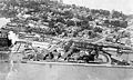 Aerial view -1920
 -
 Aerial view -1920
 -
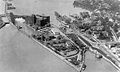 Aerial view -1920


Miscellanea
Neil Peart, drummer for the rock band Rush, grew up in Port Dalhousie. The song, "Lakeside Park", off of their 1975 album Caress of Steel, is about his summers at the beach.
Parts of the film The Skulls, starring Joshua Jackson and Paul Walker, was shot in Port Dalhousie at the Henley rowing course and along the pier.
Most of the film The Boy in Blue, starring Nicolas Cage, was filmed in different parts of Port Dalhousie.