
Puerto Rico Highway 511
Highway 511 | ||||
|---|---|---|---|---|
| Ruta 511 | ||||
.svg) | ||||
| Route information | ||||
| Maintained by Puerto Rico DTPW | ||||
| Length | 18.9 km[1][2] (11.7 mi) | |||
| Major junctions | ||||
| South end | ||||
| North end | ||||
| Location | ||||
| Country | United States | |||
| Territory | Puerto Rico | |||
| Municipalities | Ponce | |||
| Highway system | ||||
| ||||

Puerto Rico Highway 511 (PR-511) is a tertiary[3] state highway in the municipality of Ponce in Puerto Rico. With a length of 16.4 km (10.2 mi), it extends from PR-14 between barrios Coto Laurel and Real to PR-143 between Ponce and Jayuya.
Route description[edit]
The road runs south to north, connecting PR-14 at its southern terminus on the Coto Laurel–Real line to PR-143 at its northern terminus on the Ponce–Jayuya municipal limit. It runs mostly along the Inabón River in the road's southern portions through Barrio Real and along the Anón River in its northern portion, once the road enters Barrio Anón. The road is 16.4 kilometers (10.2 mi) long.[1][4]
-
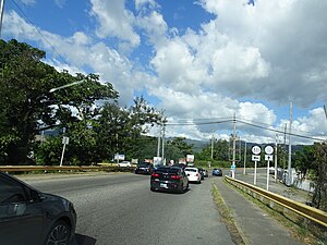
 A stretch of PR-511 northbound in Barrio Real, Ponce, Puerto Rico
 -
 A stretch of PR-511 in the hills of Barrio Real, looking north
.jpg)
.jpg)
Improvements[edit]
Puerto Rico Legislature Joint Resolution 795 of 5 July 2010, which sought to order the Oficina de Gerencia y Presupuesto the assignment of $4.2 million to the Puerto Rico Highways and Transportation Authority (Spanish: Autoridad de Carreteras y Transportación) to make improvements to the road, was not approved.[1]
On 30 March 2011, Puerto Rico Senator Larry Seilhamer Rodríguez, presented Senate Joint Resolution 774 to order the Puerto Rico Highway and Transportation Authority to rebuild PR-511 at km 11.5 (in the Real Anón sector) where the road had been severely damaged in 2005 due to heavy rains.[5]
In October 2013, the residents of Barrio Anón collected money to make the improvements themselves but their efforts were halted after learning they could be the subjects of lawsuits.[1]
History[edit]
Prior to its numerical designation, PR-511 was only known as Carretera Real-Anón.[6] In 1930, 2.1 km (1.3 mi) of this road were built by Lorenzo J. Dávila, the contractor for the job, at a cost of $18,755.[7] The current numerical designation corresponds to the 1953 Puerto Rico highway renumbering, a process implemented by the Puerto Rico Department of Transportation and Public Works (Spanish: Departamento de Transportación y Obras Públicas) that increased the insular highway network to connect existing routes with different locations around Puerto Rico.
Major intersections[edit]
-
 PR-14 east at the southern terminus of PR-511
 -
 PR-14 west at PR-511 intersection
.jpg)
.jpg)
| Municipality | Location | km[8][2] | mi | Destinations | Notes | ||
|---|---|---|---|---|---|---|---|
| Ponce | Coto Laurel–Real line | 0.0 | 0.0 | Southern terminus of PR-511 | |||
| Anón | 16.4 | 10.2 | PR-Sector Hacienda Cortada – Anón | Northern terminus of southern segment; dead end road | |||
| Gap in PR-511 due to a landslides as of January 2015 | |||||||
| 2.5 | 1.6 | PR-Sector Hogares Seguros – Anón | Southern terminus of northern segment; dead end road | ||||
| Ponce–Jayuya municipal line | Anón–Jauca line | 0.0 | 0.0 | Northern terminus of PR-511 | |||
1.000 mi = 1.609 km; 1.000 km = 0.621 mi
| |||||||
See also[edit]
References[edit]
- ^ a b c d Impiden vecinos arreglar vía en Real Anón. Reinaldo Millán. La Perla del Sur. Ponce, Puerto Rico. (Printed Edition: Title: Con las manos atadas: Impiden vecinos arreglar vía en Real Anón; Date: 16 October 2013; Year: 31; Issue: 1559. Page: 12.) Retrieved 16 October 2013.
- ^ a b Google (1 March 2020). "PR-511 north" (Map). Google Maps. Google. Retrieved 1 March 2020.
- ^ PRHTA Design Manual: Chapter 1, General Design Criteria. Departamento de Transportación y Obras Publicas de Puerto Rico. page 1-2. Accessed 9 May 2019.
- ^ Ponce: Vecinos reparan hoyos en PR-511. Reinaldo Millán. La Perla del Sur. Ponce, Puerto Rico. 8 January 2014. Retrieved 10 January 2014.
- ^ Archived here by the WayBack Machine on 12 March 2012 from the original formerly located at Ordenan a Carreteras reconstruir la PR-511 barrio Real Anón en Ponce. 30 Marzo 2011. El Sur a la Vista. Ponce, Puerto Rico. Retrieved 31 March 2011.
- ^ "Ponce, Memoria Núm. 27" (PDF). Puerto Rico Planning Board (in Spanish). 1953. Retrieved 21 August 2023.
- ^ Revista de Obras Públicas de Puerto Rico. p. 86. Year VII. March 1930. Issue 3. Accessed 1 August 2020.
- ^ Google (1 March 2020). "PR-511 south" (Map). Google Maps. Google. Retrieved 1 March 2020.