
Sabil-Kuttab of Qaytbay
(Redirected from Sabil-Kuttab of Sultan Qaytbay)
| Sabil-Kuttab of Sultan Qaytbay | |
|---|---|
| Native name Arabic: سبيل وكتـّاب السلطان قايتباي | |
 View of the sabil-kuttab from Saliba street. | |
| Type | Sabil; kuttab |
| Coordinates | 30°01′51″N 31°15′17″E / 30.03083°N 31.25472°E |
| Founder | Sultan al-Ashraf Qaytbay |
| Built | 1479 CE (884 AH) |
| Restored | 1999 |
| Restored by | Supreme Council of Antiquities; Agencia Española de Cooperacion Internacional |
| Current use | tourist attraction (historic site); the Suzanne Mubarak Center for Islamic Civilization |
| Architectural style(s) | Mamluk, Islamic |
The Sabil-Kuttab of Sultan Qaytbay is a Mamluk-era charitable foundation and building in Cairo, Egypt. It was built in 1479 on the order of Sultan al-Ashraf Qaytbay and is located on Saliba Street in the historic districts of Cairo.[1][2][3]
The building is composed of a sabil (a water distribution kiosk) on the ground floor and a kuttab (primary school teaching the Qur'an) on the upper floors. Below the structure, underground, is a cistern from which water was drawn for the sabil. The structure was the first free-standing sabil-kuttab in Cairo; a type of building that would later become quite common during the Ottoman period.[4]
Gallery[edit]
-
 Entrance portal.
 -
 Exterior polychrome marble and stone-carving decoration
 -
 Interior of sabil chamber, with window through which attendant gave out water.
 -
 Marble salsabil over which water flowed inside the attendant's chamber.
 -
 Painted wooden ceiling inside the sabil chamber.
 -
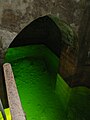 The underground water cistern.


See also[edit]
- Sabil of Qaytbay (at the Temple Mount in Jerusalem)
- Wikala and Sabil-Kuttab of Qaytbay (at al-Azhar)
- Funerary complex of Sultan Qaytbay (at the Northern Cemetery)
- Mamluk architecture
References[edit]
Wikimedia Commons has media related to Sabil-Kuttab of Qaytbay.
- ^ Williams, Caroline (2018). Islamic Monuments in Cairo: The Practical Guide (7th ed.). Cairo: The American University in Cairo Press. p. 289.
- ^ Torky, Tarek (2019). "Sabil (Water Dispensary) and Kuttab (Qur'anic School) of Sultan Qaytbay". Discover Islamic Art, Museum With No Frontiers. Retrieved November 6, 2019.
- ^ Behrens-Abouseif, Doris. 2007. Cairo of the Mamluks: A History of Architecture and its Culture. Cairo: The American University in Cairo Press.
- ^ Blair, Sheila S.; Bloom, Jonathan (1995). The Art and Architecture of Islam: 1250-1800. New Haven; London: Yale University Press. pp. 92.

This article about an Egyptian building or structure is a stub. You can help Wikipedia by expanding it. |