Shakhty
Shakhty
Шахты | |
|---|---|
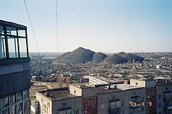
 A view of the city from the KhBK (cotton plant) area | |
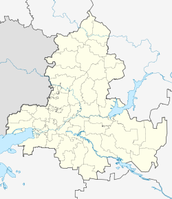
| Coordinates: 47°42′0″N 40°14′0″E / 47.70000°N 40.23333°E | |
| Country | Russia |
| Federal subject | Rostov Oblast[1] |
| Founded | 1805 |
| Government | |
| • Mayor | Vladimir Mamonov (acting)[2] |
| Elevation | 100 m (300 ft) |
| Population | |
| • Total | 239,987 |
| • Rank | 78th in 2010 |
| • Subordinated to | Shakhty Urban Okrug[1] |
| • Capital of | Shakhty Urban Okrug[1] |
| • Urban okrug | Shakhty Urban Okrug[4] |
| • Capital of | Shakhty Urban Okrug[4] |
| Time zone | UTC+3 (MSK |
| Postal code(s)[6] | 346500 |
| Dialing code(s) | +7 8636 |
| OKTMO ID | 60740000001 |
| City Day | Third Sunday of September |
| Website | www |
Shakhty (Russian: Шахты, IPA: [ˈʂaxtɨ]) is a city in Rostov Oblast, Russia, located on the southeastern spur of the Donetsk mountain ridge, 75 kilometers (47 mi) northeast of Rostov-on-Don. Population: 239,987 2010 Census.[3]
History
In 1805, sergeant-major Popov founded a small settlement near the Grushevka River. The settlement later became known as Popovka. In 1809, Popov built the first mine. Twelve Cossacks and fourteen peasant serfs lived in Popovka at that time. From 1881 to 1921, it was known as Alexandrovsk-Grushevsky (Александровск-Грушевский).
By 1914, the population had reached 54,000. The main source of income was coal mining, which had been carried out in that region since the 18th century. The population was poor, but the town had rail, telegraph and telephone networks, electricity and plumbing as well as libraries, hospitals and a post office. Most of the merchants and industrialists lived in Rostov and Novocherkassk.[7]
1917 saw the city change hands three times, until it was taken on April 28, 1919, by the Don Army, under General Fitzkhelaurov. For twenty months it was independent of the Bolsheviks, but was ravaged by typhoid.
On January 13, 1921, it was finally given its present name. The name "Shakhty" ("mine shafts" in English) was chosen, because of the city's association with coal mining. During the 1920s, many of the churches and the archives were destroyed. As with the rest of the Soviet Union, the same street names were changed.
In July 1942, during the Great Patriotic War, the town was occupied by the Germans; many coal pits and buildings were blown up by the Germans during their retreat in February, 1943. Twenty-nine of the townsmen were awarded the title of the Hero of the Soviet Union.
In 1948, production levels in the mines reached what they had been before the war. During the Leonid Brezhnev years, the city was at the height of its development, with a population of over 250,000, and about ten million tons of coal being mined each year.
Perestroika proved devastating for the city, as mines were privatized and shut down, causing massive unemployment, which led to a severe rise in crime and drug abuse. Today Shakhty is the main industrial center of the Eastern Donbass. The city is also one of the main producers and exporters of tile in Eastern Europe, Shakhtinskaya Plitka.
The city is known for the Shakhty Trial of 1928, a precursor of the show trials of the 1930s, and for being the scene of many of Andrei Chikatilo's murders.
Administrative and municipal status
Within the framework of administrative divisions, it is incorporated as Shakhty Urban Okrug—an administrative unit with the status equal to that of the districts.[1] As a municipal division, this administrative unit also has urban okrug status.[4]
Demographics
The city's population was 239,987 as of the 2010 Census;[3] up from 222,592 recorded in the 2002 Census.[8] As of the 1989 Census, the population was 225,797.[9]
International relations
Twin towns and sister cities
Shakhty is twinned with:
References
Notes
- ^ a b c d e Law #340-ZS
- ^ Official website of Shakhty Administration. Vladimir Nikiforovich Mamonov Template:Ru icon
- ^ a b c Russian Federal State Statistics Service (2011). Всероссийская перепись населения 2010 года. Том 1 [2010 All-Russian Population Census, vol. 1]. Всероссийская перепись населения 2010 года [2010 All-Russia Population Census] (in Russian). Federal State Statistics Service.
- ^ a b c Law #191-ZS
- ^ "Об исчислении времени". Официальный интернет-портал правовой информации (in Russian). June 3, 2011. Retrieved January 19, 2019.
- ^ Почта России. Информационно-вычислительный центр ОАСУ РПО. (Russian Post). Поиск объектов почтовой связи (Postal Objects Search) (in Russian)
- ^ shakhty.su: History
- ^ Federal State Statistics Service (May 21, 2004). Численность населения России, субъектов Российской Федерации в составе федеральных округов, районов, городских поселений, сельских населённых пунктов – районных центров и сельских населённых пунктов с населением 3 тысячи и более человек [Population of Russia, Its Federal Districts, Federal Subjects, Districts, Urban Localities, Rural Localities—Administrative Centers, and Rural Localities with Population of Over 3,000] (XLS). Всероссийская перепись населения 2002 года [All-Russia Population Census of 2002] (in Russian).
- ^ Всесоюзная перепись населения 1989 г. Численность наличного населения союзных и автономных республик, автономных областей и округов, краёв, областей, районов, городских поселений и сёл-райцентров [All Union Population Census of 1989: Present Population of Union and Autonomous Republics, Autonomous Oblasts and Okrugs, Krais, Oblasts, Districts, Urban Settlements, and Villages Serving as District Administrative Centers]. Всесоюзная перепись населения 1989 года [All-Union Population Census of 1989] (in Russian). Институт демографии Национального исследовательского университета: Высшая школа экономики [Institute of Demography at the National Research University: Higher School of Economics]. 1989 – via Demoscope Weekly.
Sources
- Законодательное Собрание Ростовской области. Закон №340-ЗС от 25 июля 2005 г. «Об административно-территориальном устройстве Ростовской области», в ред. Закона №270-ЗС от 27 ноября 2014 г. «О внесении изменений в областной Закон "Об административно-территориальном устройстве Ростовской области"». Вступил в силу со дня официального опубликования. Опубликован: "Наше время", №187–190, 28 июля 2005 г. (Legislative Assembly of Rostov Oblast. Law #340-ZS of July 28, 2005 On the Administrative-Territorial Structure of Rostov Oblast, as amended by the Law #270-ZS of November 27, 2014 On Amending the Oblast Law "On the Administrative-Territorial Structure of Rostov Oblast". Effective as of the official publication date.).
- Законодательное Собрание Ростовской области. Закон №191-ЗС от 19 ноября 2004 г. «Об установлении границы и наделении статусом городского округа муниципального образования "Город Шахты"», в ред. Закона №627-ЗС от 12 января 2007 г «О внесении изменений в некоторые областные Законы об установлении границ муниципальных образований и наделении их соответствующим статусом». Вступил в силу со дня официального опубликования. Опубликован: "Наше время", №285–286, 23 ноября 2004 г. (Legislative Assembly of Rostov Oblast. Law #191-ZS of November 19, 2004 On Establishing the Border and Granting Urban Okrug Status to the Municipal Formation of the "City of Shakhty", as amended by the Law #627-ZS of January 12, 2007 On Amending Various Oblast Laws on Establishing the Borders of the Municipal Formations and on Granting Them an Appropriate Status. Effective as of the official publication date.).
External links


