
Singleton, New South Wales
| Singleton New South Wales | |||||||||
|---|---|---|---|---|---|---|---|---|---|
 St Patrick's Church | |||||||||
 Singleton | |||||||||
| Coordinates | 32°34′0″S 151°10′11″E / 32.56667°S 151.16972°E | ||||||||
| Population | 16,346 (2018)[1] | ||||||||
| Postcode(s) | 2330 | ||||||||
| Elevation | 40 m (131 ft) | ||||||||
| Location |
| ||||||||
| LGA(s) | Singleton Shire Council | ||||||||
| County | Northumberland | ||||||||
| State electorate(s) | Upper Hunter | ||||||||
| Federal division(s) | Hunter | ||||||||
| |||||||||
Singleton is a town on the banks of the Hunter River in New South Wales, Australia. Singleton is 202km (89 mi) north-north-west of Sydney, and 70 km (43 mi) north-west of Newcastle.[2][3] At June 2018, Singleton had an urban population of 16,346.[1]
Singleton's main urban area includes the town centre, Singleton Heights, Dunolly, Darlington, The Retreat, Wattle Ponds and Hunterview. Surrounding rural villages include Broke, Camberwell, Jerrys Plains, Goorangoola/Greenlands, Belford and Lower Belford.
Singleton is located on the north-eastern part of the geological structure known as the Sydney basin, which borders the New England region.[4]
Singleton is now home to a $100 million dollar lottery winner, the highest in the towns history.[5]
History[edit]
The traditional landowners of the land around what is now Singleton are the Wonnarua / Wanaruah people. The Wonnarua / Wanaruah people have occupied the land in the Upper Hunter Valley for over 30,000 years.[6]
Singleton was established in the 1820s. In its early years, it was also called Patrick's Plains.[7] The Main Northern railway line reached Singleton in 1863 and was the end of the line until 1869. The town retains many historic buildings, including the original courthouse built in 1841, various large churches and many traditional Australian pubs. The countryside surrounding Singleton contains an unusual number of fine old mansions, reflecting the aristocratic nature of land grants when the area was settled. They include 'Neotsfield' (1828), the elaborate 'Baroona' (1829), 'Abbey Green' (1865) and stunning 'Minimbah' (1877).
A Telegraph Office was opened in Singleton on 25 February 1861 during the construction of the first telegraph line to Queensland. That Office combined with the Post Office on 1 January 1870. In May 1942, the community celebrated the appointment of the town's first female Telegram Messenger – Miss Daphne Lambkins. She was one of the first female Messengers in the Commonwealth.[8]
Singleton was subject to the major flooding of the Hunter River in 1955, causing extensive damage to the town. When the area was being settled, the government originally attempted to create a town at Whittingham in a flood-free area, but the town grew by the river nonetheless. An embankment was constructed following the 1955 floods to help protect the town against any future flooding.
-

-

-
 All Saints' Anglican Church
 -
 All Saints' Church Rectory


Baroona[edit]
It was built in 1829 with property being on 33 hectares.[9] John Larnach built the 1600ha house on land owned by his father-in-law James Mudie.[9] Larnach and Mudie worked together on property with the helped of convict labour to create a prominent agricultural establishment producing wool, meat and wheat.[10] He was assigned 64 convicts which comprised 67% English, 25% Irish and a few from Scotland with a median age of 28 years old.[11] A servant set fire to the estate in 1832.[12] In 1893 Baroona was given an addition of a spiral staircase, a card room and a viewing terrace.[13]
1833 Revolt[edit]
In November 1833 six convicts decided to revolt because of their poor treatment, meagre provisions and floggings.[12] Larnach and Mudie were away from the property at the time washing sheep.[10] The rebels stole clothes, guns, food and horses.[10] They held Emily Larnach hostage with several servants locking them in an outhouse.[10] They also attempted to kill John Larnach but he managed to escape to Henry Dangar's house.[10] Five of six men involved the riots were sentenced to death.[12]During the months preceding the revolt nearly two thirds of the convicts had been flogged with one third of them being flogged multiple times.[12] The subsequent trial in December 1833 led to the convicts being charged with stealing from two dwelling houses, shooting with intent to kill, aiding and abetting and an attempted murder.[11] The inquiry produced little evidence of illegal work practice or servants and convicts being overworked.[11]
Pelerin[edit]
Located on 30 Edinburgh Avenue on 3370 sqm,[14] Pelerin was built in the 1830s and is a stone-faced two storey building.[15] In 1899 it sustained major storm damage.[15] The home was rebuilt for D H Dight who decided to retain its original name.[15] It has 27 rooms including 5 bedrooms, 3 bathrooms, study, and a timber kitchen.[14] It has cedar joinery with 15-inch skirting board with 11-foot ceilings.[14]
Ardersier House and Garden[edit]
The house was built in 1871 by Singleton's first mayor Alexander Munro.[15] He named his property Ardersier after his birthplace in Scotland.[15] It is a 1.26 ha property located at 48 Maitland Road.[16] In 1981 it was listed in the National Trust.[16] It has three bedrooms, two bathrooms, plus study and an attic of two large rooms.[16]
Hambledon Hill[edit]
Completed in 1865, the land was given on a free grant to brothers Edward, Henry and William Nowland in 1824.[17] Located on 535 Hambledon Hill Road,[18] the land is 50 acres and is currently owned by artist Dale Frank.[19] It has 7 bedrooms and 5 bathrooms.[18] It is a two-storey sandstock brick home on stone foundations with hipped slate roof, a deep stone paved verandah, with cast-iron balustrade and French Doors.[17] Last sold in September 2007 for $720,000.[18]
Population[edit]
According to the 2021 census, there were 17,018 people in the Singleton urban area.
- Aboriginal and Torres Strait Islander people made up 8.7% of the population.
- 85.4% of people were born in Australia. The next most common countries of birth were New Zealand 2.1%, England 1.5%, Philippines 1.1% and South Africa 0.6%.
- 90.3% of people spoke only English at home.
- The most common responses for religion were No Religion 36.4%, Anglican 22.2%, and Catholic 21.6%.[20]
Climate[edit]
Singleton experiences a humid subtropical climate (Köppen: Cfa, Trewartha: Cfal); with hot summers and mild winters; and with a moderately low precipitation amount of 652.7 millimetres (25.71 in). Precipitation is more abundant during the summer, as the town is affected by foehn winds during winter and spring.[21] The highest temperature recorded at Singleton was 43.6 °C (110.5 °F) on 15 January 2001; the lowest recorded was –4.2 °C (24.4 °F) on 16 August 1994.
| Climate data for Singleton Water Board, New South Wales (1991–2002 normals and extremes); 40 m AMSL | |||||||||||||
|---|---|---|---|---|---|---|---|---|---|---|---|---|---|
| Month | Jan | Feb | Mar | Apr | May | Jun | Jul | Aug | Sep | Oct | Nov | Dec | Year |
| Record high °C (°F) | 43.6 (110.5) |
40.0 (104.0) |
41.0 (105.8) |
34.7 (94.5) |
28.2 (82.8) |
25.4 (77.7) |
26.0 (78.8) |
30.4 (86.7) |
33.0 (91.4) |
39.0 (102.2) |
43.0 (109.4) |
41.4 (106.5) |
43.6 (110.5) |
| Mean maximum °C (°F) | 37.6 (99.7) |
35.1 (95.2) |
32.4 (90.3) |
29.4 (84.9) |
24.7 (76.5) |
21.1 (70.0) |
20.7 (69.3) |
24.5 (76.1) |
28.4 (83.1) |
32.0 (89.6) |
34.9 (94.8) |
36.0 (96.8) |
37.6 (99.7) |
| Mean daily maximum °C (°F) | 30.6 (87.1) |
29.6 (85.3) |
27.7 (81.9) |
25.4 (77.7) |
21.1 (70.0) |
18.3 (64.9) |
18.0 (64.4) |
20.1 (68.2) |
23.1 (73.6) |
26.0 (78.8) |
27.6 (81.7) |
29.7 (85.5) |
24.8 (76.6) |
| Daily mean °C (°F) | 24.0 (75.2) |
23.4 (74.1) |
21.5 (70.7) |
18.3 (64.9) |
14.9 (58.8) |
12.0 (53.6) |
11.4 (52.5) |
12.6 (54.7) |
15.6 (60.1) |
18.4 (65.1) |
20.6 (69.1) |
22.8 (73.0) |
18.0 (64.3) |
| Mean daily minimum °C (°F) | 17.3 (63.1) |
17.2 (63.0) |
15.2 (59.4) |
11.1 (52.0) |
8.6 (47.5) |
5.6 (42.1) |
4.8 (40.6) |
5.0 (41.0) |
8.0 (46.4) |
10.7 (51.3) |
13.5 (56.3) |
15.9 (60.6) |
11.1 (51.9) |
| Mean minimum °C (°F) | 13.5 (56.3) |
13.5 (56.3) |
11.1 (52.0) |
7.2 (45.0) |
4.0 (39.2) |
1.2 (34.2) |
0.0 (32.0) |
0.0 (32.0) |
3.0 (37.4) |
5.6 (42.1) |
9.1 (48.4) |
12.1 (53.8) |
0.0 (32.0) |
| Record low °C (°F) | 9.6 (49.3) |
9.6 (49.3) |
7.5 (45.5) |
2.5 (36.5) |
0.4 (32.7) |
−2.0 (28.4) |
−3.9 (25.0) |
−4.2 (24.4) |
0.4 (32.7) |
2.5 (36.5) |
5.0 (41.0) |
8.1 (46.6) |
−4.2 (24.4) |
| Average precipitation mm (inches) | 70.2 (2.76) |
107.6 (4.24) |
75.1 (2.96) |
38.3 (1.51) |
37.8 (1.49) |
31.7 (1.25) |
41.7 (1.64) |
27.6 (1.09) |
44.1 (1.74) |
32.8 (1.29) |
59.2 (2.33) |
86.6 (3.41) |
652.7 (25.71) |
| Average precipitation days (≥ 1.0 mm) | 7.4 | 7.5 | 7.3 | 3.9 | 5.6 | 4.6 | 4.7 | 4.2 | 5.8 | 5.0 | 7.6 | 6.8 | 70.4 |
| Average relative humidity (%) | 62.5 | 67.5 | 69.0 | 66.5 | 72.5 | 70.5 | 68.5 | 60.0 | 57.0 | 54.5 | 57.5 | 60.0 | 63.8 |
| Average dew point °C (°F) | 16.4 (61.5) |
17.1 (62.8) |
15.7 (60.3) |
12.8 (55.0) |
10.7 (51.3) |
7.6 (45.7) |
6.4 (43.5) |
5.9 (42.6) |
8.1 (46.6) |
10.3 (50.5) |
12.3 (54.1) |
14.9 (58.8) |
11.5 (52.7) |
| Source: Australian Bureau of Meteorology (temperature, precipitation, humidity- 1991–2002 extremes)[22] | |||||||||||||
Transport[edit]
The town is located at the junction of the New England Highway and Putty Road. The Golden Highway branches northwest from the New England Highway ten kilometres south of Singleton. Singleton is also served by local and long-distance rail services. Singleton railway station on the Main Northern railway line is located at the southern end of the town centre. There are also bus services, both intercity and local. A bypass for the New England Highway is planned to divert traffic from Singleton, more than 26,000 vehicles travel through Singleton daily, the environmental assessment and concept design are open to public feedback in 2019.
Economy[edit]
Major industries near Singleton include coal mining, electricity generation, light industry, vineyards, horse breeding and cattle production. Dairying was once a mainstay in the area, but has declined.
The largest employment industry is coal mining, which employs 24 percent of the town's workforce.[23] Defence is the second largest employer with almost 4 percent of the workforce.[23]
Lone Pine Barracks is located 8 kilometres (5.0 mi) south of Singleton.
Media[edit]
Print[edit]
The Singleton Argus is a bi-weekly newspaper which was established in 1874. It is currently owned and published by Australian Community Media. The weekly newspaper that serves Singleton and the Hunter Valley is The Hunter Valley News,[24] which, along with the Newcastle Herald newspaper (daily, except Sundays), is published by Australian Community Media. The Hunter River Times was established in 2020 and provides news for the surrounding Singleton area.
Radio[edit]
Radio stations serving both Newcastle and the Hunter Valley can be received in Singleton.
Television[edit]
Singleton is part of the Newcastle–Hunter Region television market, which is served by 5 television networks, three commercial and two national services (which include new sub-channels that started in 2009 for the commercial networks and in recent years from the national services).
Tourism[edit]

- Sundial. Singleton is home to one of the world's largest sundials, presented by a local coal mine for the 1988 Bicentennial Celebrations.
- Wineries. The town is close to the famous Pokolbin wine region (southeast). There are also many wineries in the shire, especially around Broke.
- Boating. Lake St Clair is an artificial lake located to the north of the town, with facilities for boating and camping.
- National Parks. Wollemi and Yengo National Parks are located south of the town via the Putty Road. Barrington Tops National Park borders the north of the shire.
- Museums. Singleton has three main museums, the Singleton Historic Society Museum in Burdekin Park, the Royal Australian Infantry Corps Museum at the nearby barracks and the Mercy Convent Museum 'Sacred Spaces' within the grounds of the Convent of the Sisters of Mercy (Singleton).
-
 St Patrick's Catholic Church, Queen Street
 -
 Convent of the Sisters of Mercy
 -
 St Catherine's College
 -
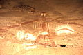 Aboriginal painting, Baiame Cave, Milbrodale


Heritage listings[edit]
Singleton has a number of heritage-listed sites, including:
- 25 Dangar Road: Singleton District Hospital[25]
- 25–27 George Street: Singleton Post Office[26]
- 88 George Street: Ewbank[27]
- Main Northern railway: Singleton railway station[28]
- Queen Street: St Patrick's Roman Catholic Church Cemetery[29]
Education[edit]
Singleton is home to a number of educational facilities. These include schools operated by NSW Department of Education and two non-government schools at both Primary and Secondary levels; as well as a TAFE campus, Singleton Community College and a number of pre-schools. St Catherine's Catholic College provides classes from kindergarten to year 12, while Australian Christian College has classes from pre-kindergarten to year 12.
Schools operated by NSW Department of Education include:
- Broke Public School
- Jerrys Plains Public School
- King Street Public School
- Milbrodale Public School
- Kirkton Public School
- Mount Pleasant Public School
- Singleton Heights Public School
- Singleton Public School
- Singleton High School
Hunter Institute of TAFE operates a campus in Singleton. It provides training and further education as well as collaborating with secondary schools for students completing Senior years.
Notable people[edit]
- Joseph Burnett – born in Singleton in 1899 and is best known as the Captain of the ill-fated HMAS Sydney, which was lost on 19 November 1941 in a battle with German auxiliary cruiser Kormoran
- Charles Dutton – a Queensland politician and great-great grandfather of Peter Dutton was born in Singleton
- Dale Frank – an artist, was born and currently lives in Singleton
- Kerrod Holland – a rugby league player
- Joy McKean – an Australian country music matriarch, was born in Singleton in 1930
- Cherie Nowlan – a television and film producer, was born in Singleton, best known for directing the 1997 film Thank God He Met Lizzie
- Toby Price – the 2016 Dakar Rally champion lives in Singleton
- Wendy Richardson OAM – a playwright, was born in Singleton in 1933
- Sean Rudder – a rugby league player
- Josh Valentine – a rugby union player
- Sir Charles Wade – a former premier of New South Wales, serving from 1907 to 1910, was born in Singleton
- Jimmy Crute – a professional mixed martial artist signed to the UFC, was born in Singleton
Sister city[edit]
![]() Japan - Takahata, Yamagata, Japan[30]
Japan - Takahata, Yamagata, Japan[30]
See also[edit]
References[edit]
- ^ a b "3218.0 – Regional Population Growth, Australia, 2017-18: Population Estimates by Significant Urban Area, 2008 to 2018". Australian Bureau of Statistics. 27 March 2019. Retrieved 25 October 2019. Estimated resident population, 30 June 2018.
- ^ Robinson's Road Atlas of Australia, Lansdowne Press, 1983
- ^ "Distance from Singleton, Australia to other cities - Distance Calculator". www.geodatos.net. Retrieved 18 December 2019.
- ^ http://www.dpi.nsw.gov.au/__data/assets/image/0007/96847/20758.gif [bare URL image file]
- ^ "Singleton couple win $100 million in Powerball lottery". The Singleton Argus. 1 February 2024. Retrieved 9 February 2024.
- ^ "Aboriginal History". Retrieved 26 May 2021.
- ^ Gee, Valma. "Patrick's Plains". Family History society of Singleton. Retrieved 24 January 2010.
- ^ Johnstone, James Dr. "Telegrams in Australia". Retrieved 24 August 2022.
- ^ a b AUSTIN, PETER (3 February 2020). "Purchase your own 'castle'". Hunter Valley News. Retrieved 17 March 2021.
- ^ a b c d e "Local Landmark: Baroona". Lindy Harris. 6 November 2019. Retrieved 17 March 2021.
- ^ a b c Roberts, David (2018). "Masters, Magistrates and the Management of Complaint: The 1833 Convict Revolt at Castle Forbes and the Failure of Local Governance". University. 19: 57–94.
- ^ a b c d Ford, Lisa; Roberts, David Andrew (4 December 2020). "The Convict Peace: The Imperial Context of the 1833 Convict Revolt at Castle Forbes". The Journal of Imperial and Commonwealth History. 49: 1–21. doi:10.1080/03086534.2020.1848401. ISSN 0308-6534. S2CID 230626235.
- ^ Debbie (2 January 2020). "Luxury heritage estate and acreage: 'Baroona'". The Real Estate Conversation. Retrieved 17 March 2021.
- ^ a b c "30 Edinburgh Avenue, Singleton, Nsw, Australia, 2330 | "PELERIN" circa 1889 | $1150000 | Offered in Australia | www.WhatsitWorth.com.au". www.whatsitworth.com.au. Retrieved 31 March 2021.
- ^ a b c d e "Historical Houses in the Singleton | Singleton Council". www.singleton.nsw.gov.au. Retrieved 31 March 2021.
- ^ a b c "Sold House - "ARDERSIER" 48 Maitland Road, SINGLETON, NSW 2330". Ray White Singleton. Retrieved 31 March 2021.
- ^ a b Aussie~mobs (1 January 2010), Hambledon Hill House, Maison Dieu, near Singleton, Australia, retrieved 31 March 2021
- ^ a b c "535 Hambleton Hill Road Hambledon Hill NSW 2330".
- ^ Nichols, Louise (8 October 2020). "Hambledon Hill to open its garden to the public on November 1". The Singleton Argus. Retrieved 31 March 2021.
- ^ "2021 Singleton, Census All persons QuickStats | Australian Bureau of Statistics". www.abs.gov.au. Retrieved 27 May 2023.
- ^ "Rain Shadows". www.willyweather.com.au. Retrieved 5 May 2022.
- ^ "Singleton Water Board, NSW Climate (1991–2002 normals and extremes)". Australian Bureau of Meteorology. Retrieved 4 May 2022.
- ^ a b Australian Bureau of Statistics (31 October 2012). "Singleton (SUA)". 2011 Census QuickStats. Retrieved 17 November 2016.
- ^ "Hunter Valley News". huntervalleynews.net.au. Retrieved 11 November 2012.
- ^ "Singleton District Hospital". New South Wales State Heritage Register. Department of Planning & Environment. H00833. Retrieved 18 May 2018.
 Text is licensed by State of New South Wales (Department of Planning and Environment) under CC-BY 4.0 licence.
- ^ "Post Office (former)". New South Wales State Heritage Register. Department of Planning & Environment. H00478. Retrieved 18 May 2018. Text is licensed by State of New South Wales (Department of Planning and Environment) under CC-BY 4.0 licence.
- ^ "Ewbank & Outbuildings". New South Wales State Heritage Register. Department of Planning & Environment. H00174. Retrieved 18 May 2018. Text is licensed by State of New South Wales (Department of Planning and Environment) under CC-BY 4.0 licence.
- ^ "Singleton Railway Station group". New South Wales State Heritage Register. Department of Planning & Environment. H01246. Retrieved 18 May 2018. Text is licensed by State of New South Wales (Department of Planning and Environment) under CC-BY 4.0 licence.
- ^ "St. Patrick's Roman Catholic Church Cemetery". New South Wales State Heritage Register. Department of Planning & Environment. H00233. Retrieved 18 May 2018. Text is licensed by State of New South Wales (Department of Planning and Environment) under CC-BY 4.0 licence.
- ^ "International Exchange". List of Affiliation Partners within Prefectures. Council of Local Authorities for International Relations (CLAIR). Archived from the original on 22 December 2015. Retrieved 21 November 2015.
External links[edit]
- "Hunter River catchment" (map). Office of Environment and Heritage. Government of New South Wales.
- Singleton Shire Council
- Tourist guide for Singleton - Visit NSW
| International | |
|---|---|
| National | |
| Geographic | |