
Sluis
Sluis
Sluus (Zeeuws) | |
|---|---|
.JPG) Skyline of Sluis | |
 Flag  Coat of arms | |
.svg) Location in Zeeland | |
| Coordinates: 51°18′30″N 3°23′10″E / 51.30833°N 3.38611°E | |
| Country | Netherlands |
| Province | Zeeland |
| Government | |
| • Body | Municipal council |
| • Mayor | Marga Vermue-Vermue (CDA) |
| Area | |
| • Total | 307.16 km2 (118.60 sq mi) |
| • Land | 279.36 km2 (107.86 sq mi) |
| • Water | 27.80 km2 (10.73 sq mi) |
| Elevation | 2 m (7 ft) |
| Population (January 2021)[4] | |
| • Total | 23,166 |
| • Density | 83/km2 (210/sq mi) |
| Time zone | UTC+1 (CET) |
| • Summer (DST) | UTC+2 (CEST) |
| Postcode | 4500–4519, 4524–4529 |
| Area code | 0117 |
| Website | www |
Sluis (Dutch: [slœys] ⓘ; Zeelandic: Sluus [slys]; French: Écluse) is a town and municipality located in the west of Zeelandic Flanders, in the south-western Dutch province of Zeeland.
The current incarnation of the municipality has existed since 1 January 2003. The former municipalities of Oostburg and Sluis-Aardenburg merged on that date. The latter of these two municipalities was formed from a merger between the previous municipality named Sluis and the former municipality of Aardenburg in 1995.
History[edit]

The town received city rights in 1290. In 1340 the Battle of Sluys was fought nearby at sea during the Hundred Years' War. There is a record of one of the first lotteries with money on 9 May 1455 of 1737 florins (US$170,000, in 2014).
During the Eighty Years' War in 1587 the town was captured by Spanish troops under the Duke of Parma and was retaken in 1604 by a Dutch and English force under Maurice of Nassau.
From 2006 until its closure in 2013, Oud Sluis was one of only two Michelin three-starred restaurants in the entire country.
Geography[edit]

In addition to the town of Sluis itself, the municipality is made up of the following population centres:
- Aardenburg
- Breskens
- Cadzand
- Draaibrug
- Eede
- Groede
- Heille
- Hoofdplaat
- IJzendijke
- Nieuwvliet
- Oostburg
- Retranchement
- Schoondijke
- Sint Anna ter Muiden
- Sint Kruis
- Terhofstede
- Waterlandkerkje
- Zuidzande
- Zwindorp
Sint Anna ter Muiden, with a population of only 50 (2001), is a small village about 1 km west of the town of Sluis, located on the westernmost point of the Netherlands.
Demography[edit]
The population of the city is 2,040 (as of 2001).
Transport[edit]
A ferry connection across the Westerschelde exists between Breskens and Vlissingen. After the opening of the Westerschelde tunnel near Terneuzen in 2003, the ferry now carries only pedestrian and bicycle traffic.
Notable people[edit]


- John Crabbe (before 1305 in Muide – 1352)l a Flemish merchant, pirate and soldier
- Joost de Soete (ca.1510/1520 in Sluis – 1589), a Dutch nobleman and Field Marshal
- Jacob van Loo (1614 in Sluis – 1670), a painter of the Dutch Golden Age
- Joan Blasius (1639 in Cadzand — 1672), a Dutch poet, playwright, translator and lawyer
- Johanna Jacoba van Beaumont (ca.1752 in Sluis - 1827), a politically active journalist, feminist and editor
- Johan Hendrik van Dale (1828 in Sluis - 1872), a Dutch teacher, archivist and lexicographer
- Ernst Oppler (1867–1929), German impressionist painter, lived for some years in Sluis
- Jan Eekhout (1900 in Sluis - 1978), a Dutch writer, poet, translator and Nazi
- Herman Wijffels (born 1942 in Turkeye), a retired Dutch politician and businessman
- Hans Wijers (born 1951 in Oostburg), a retired Dutch politician and businessman
- Ate de Jong (born 1953 in Aardenburg), a Dutch film director[5]
Sport[edit]
- Willem van Hanegem (born 1944 in Breskens), a Dutch former football midfielder with over 50 caps and 600 appearances in the top flight of association football
- Annabel Kosten (born 1977 in Oostburg), a retired freestyle swimmer, bronze medallist at the 2004 Summer Olympics
Gallery[edit]
-
 The town hall and the Belfort in Sluis
 -
 The channel and the catholic church in Sluis
 -
 A street of the village Sint Anna ter Muiden
 -
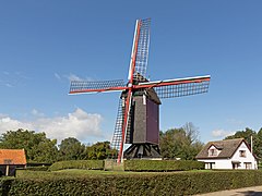 Retranchement, de Retranchementse Molen


See also[edit]
- Zwin – Nature reserve
- Battle of Sluys
- Van der Sluijs – Surname of Dutch origin
- History of the Netherlands
References[edit]
- ^ "College B&W" [Board of mayor and aldermen] (in Dutch). Gemeente Sluis. Retrieved 16 December 2013.
- ^ "Kerncijfers wijken en buurten 2020" [Key figures for neighbourhoods 2020]. StatLine (in Dutch). CBS. 24 July 2020. Retrieved 19 September 2020.
- ^ "Postcodetool for 4501BD". Actueel Hoogtebestand Nederland (in Dutch). Het Waterschapshuis. Retrieved 16 December 2013.
- ^ "Bevolkingsontwikkeling; regio per maand" [Population growth; regions per month]. CBS Statline (in Dutch). CBS. 1 January 2021. Retrieved 2 January 2022.
- ^ IMDb Database retrieved 5 August 2019
External links[edit]
 Media related to Sluis at Wikimedia Commons
- Official website (in Dutch)
Places adjacent to Sluis | ||||||||||||||||
|---|---|---|---|---|---|---|---|---|---|---|---|---|---|---|---|---|
| ||||||||||||||||
Municipalities of Zeeland | ||
|---|---|---|
 | ||
| ||
| International | |
|---|---|
| National | |
| Geographic | |