
Snowdoun, Alabama
Snowdoun, Alabama | |
|---|---|
 Snowdoun  Snowdoun | |
| Coordinates: 32°14′30″N 86°17′47″W / 32.24167°N 86.29639°W | |
| Country | United States |
| State | Alabama |
| County | Montgomery |
| Elevation | 282 ft (86 m) |
| Time zone | UTC-6 (Central (CST)) |
| • Summer (DST) | UTC-5 (CDT) |
| Area code | 334 |
| GNIS feature ID | 127083[1] |
Snowdoun is an unincorporated community in Montgomery County, Alabama, United States. Snowdoun is located on U.S. Highway 331 9.5 miles (15.3 km) south of Montgomery.
History[edit]
Snowdoun was named by William Falconer in honor of Mount Snowdon in Wales.[2] A post office operated under the name Snowdoun from 1859 to 1957.[3] Snowdoun is located along the route of the Federal Road.[4]
Snowdoun was formerly connected to Montgomery by the Montgomery Southern Railway, a narrow gauge railway.[5]
William Bartram camped near Snowdoun on his expedition through the southern colonies.[6]
References[edit]
- ^ "Snowdoun". Geographic Names Information System. United States Geological Survey, United States Department of the Interior.
- ^ Foscue, Virginia (1989). Place Names in Alabama. Tuscaloosa: The University of Alabama Press. p. 129. ISBN 0-8173-0410-X.
- ^ "Montgomery County". Jim Forte Postal History. Retrieved January 19, 2015.
- ^ Braund, Kathryn; Waselkov, Gregory; Christopher, Raven (2019). The Old Federal Road in Alabama. Tuscaloosa: University of Alabama Press. p. 116. ISBN 978-0-8173-5930-0.
- ^ George Woodman Hilton (1990). American Narrow Gauge Railroads. Stanford University Press. p. 304. ISBN 978-0-8047-1731-1.
- ^ Bartram Trail Conference (1979). Bartram Heritage. Brad Sanders. p. 134. GGKEY:LPJW3TZ54Y4.
Municipalities and communities of Montgomery County, Alabama, United States | ||
|---|---|---|
| Cities | 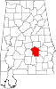 | |
| Towns | ||
| Unincorporated communities | ||
| Indian reservation | ||
| Footnotes | ‡This populated place also has portions in an adjacent county or counties | |
This Montgomery County, Alabama state location article is a stub. You can help Wikipedia by expanding it. |