Podkamennaya Tunguska
(Redirected from Stony Tunguska)
| Podkamennaya Tunguska Stony Tunguska | |
|---|---|
 | |
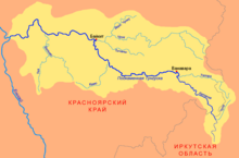
 Map of the Podkamennaya Tunguska basin | |
| Location | |
| Country | Russian Federation |
| Physical characteristics | |
| Source | Angara Range |
| • location | near Rudnogorsk, Irkutsk Oblast |
| • coordinates | 57°41′46″N 104°20′20″E / 57.696°N 104.339°E |
| • elevation | 514 m (1,686 ft) |
| Mouth | Yenisey |
• location | Podkamennaya Tunguska, Krasnoyarsk Krai |
• coordinates | 61°35′40″N 90°08′00″E / 61.5944°N 90.1333°E |
• elevation | 28 m (92 ft) |
| Length | 1,865 km (1,159 mi) |
| Basin size | 240,000 km2 (93,000 sq mi) |
| Discharge | |
| • average | 1,750 m3/s (62,000 cu ft/s) |
| Basin features | |
| Progression | Yenisey→ Kara Sea |
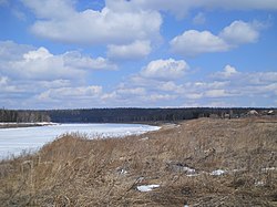
The Podkamennaya Tunguska (Russian: Подкаменная Тунгуска, literally Tunguska under the stones; Evenki: Дулгу Катэнӈа, Ket: Ӄо’ль) also known as Middle Tunguska or Stony Tunguska, is a river in Krasnoyarsk Krai, Russia.
History[edit]
In 1908, an asteroid impacted near the river and later became known as the Tunguska event.
In popular culture[edit]
The river was the set location in the Call of Duty: Black Ops Escalation DLC map, Call of The Dead.
See also[edit]
References[edit]
External links[edit]
 Media related to Podkamennaya Tunguska River at Wikimedia Commons
