
Taki-no Castle
| Taki-no-jō 滝の城 | |
|---|---|
| Tokorozawa, Saitama Prefecture, Japan | |
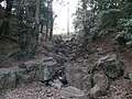
 Taki-no-jō Castle's dry moat | |
 Taki-no-jō 滝の城  Taki-no-jō 滝の城 | |
| Coordinates | 35°48′02″N 139°31′54″E / 35.80056°N 139.53167°E |
| Type | Japanese castle |
| Site information | |
| Controlled by | Oishi clan |
| Condition | Ruins |
| Site history | |
| Built | Sengoku Period |
| Built by | Ōishi Sadahisa |
| Demolished | 1590 |
Taki-no Castle (滝の城, Taki-no-jō, literally means "waterfall castle") is a flatland-hilltop Japanese castle ruin located in Tokorozawa, Saitama Prefecture. It was on a key route between the northern Kanto Plain and Hachioji.
The most recent structure was built in the 15th century by Ōishi Sadahisa and existed during the 16th-century Sengoku period of Japanese history. In 1546, the Hojo of Odawara took control and in 1569 possession passed to the Takeda.[1] Then Go-Hōjō clan expanded and improved the defences of the castle.[2]
After 1590, the castle was abandoned simultaneously with the arrival of Tokugawa Ieyasu into the region, having outlived its purpose.
The castle is now a ruin, with clear archeological evidence of the foundations of a number buildings and a dry moat. The castle name "Taki-no-jō", which literally means "waterfall castle", is due to a waterfall that exists on the eastern part of the castle grounds. The castle grounds now form a recreational park including walking paths, a children's play area and a baseball field. The park is called Taki-no-jō Castle Site Park (滝の城址公園, Taki-no-jō-shi Kōen).
-
 Shrine at the summit. Site of the honmaru main citadel
 -
 Creek and waterfall from which the castle was named.


Notes[edit]
- ^ Papinot, E. (1910)
- ^ "Taki-no Castle" (in Japanese). Tokorozawa city official. Retrieved 18 October 2021.
References[edit]
- Papinot, E. (1910). "Historical and Geographical Dictionary of Japan." 1972 Printing. Charles E. Tuttle Company, Tokyo, ISBN 0-8048-0996-8.
- On site descriptive signage.