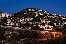
Tala, Cyprus
Tala | |
|---|---|
 | |
| Coordinates: 34°50′10″N 32°25′51″E / 34.83611°N 32.43083°E | |
| Country | |
| District | Paphos District |
| Government | |
| • Community Council President | Areti Pieridou |
| Lowest elevation | 150 m (490 ft) |
| Population (2011)[2] | |
| • Total | 2,695 |
| Climate | Csa |
| Website | www |

Tala (Greek: Τάλα) is a large suburban village 6 km north of Paphos, Cyprus. Many non-Cypriots (mostly British) have moved here permanently or have a summer home in Tala. Agios Neophytos Monastery is 1 km north. Is located 290 meters above sea level. [3][4] Tala receives an average annual rainfall of about 520 millimeters; grapevines (wine-making and table grape varieties), citrus fruits (orange trees, lemon trees), locust, olive, almond, and walnut trees, cereals, forage plants, vegetables, and a few banana trees are cultivated in the region. As far as stockbreeding is concerned, it is limited. [5][6]
History[edit]
Tala is the ancestral village of the singer Cat Stevens. His father, Stavros Georgiou, was born here in 1900. Tala is the birthplace of Chrysostomos II of Cyprus, the former Archbishop of Cyprus.
In his book 'Historic Cyprus' (second edition 1947), Rupert Gunnis (at that time Inspector of Antiquities on the island) wrote:
The Church of St. Catherine is a large and well-built edifice in the Byzantine style, with a central dome. The narthex has been added later. A year ago or so two completely unnecessary doors were pierced in the south wall. There are considerable remains of frescoes on the west wall, more especially of the Judgement, and also three heads of animals with water gushing from their mouths, representing the sources of three rivers, perhaps the Jordan, Tigris, and Euphrates. The Gospels and church plate are Russian. About a mile from the village are the ruins of a large church dedicated to St. George. Founders' tombs remain on the north and south walls, with traces of painting in their arches.
Gallery[edit]
References[edit]
- ^ "Community Council - Tala". Retrieved 2024-03-15.
- ^ "Population - Place of Residence, 2011". Statistical Service of Cyprus (CYSTAT). 17 April 2014. Archived from the original on 16 October 2014.
- ^ "GeoNames.org". www.geonames.org. Retrieved 2019-06-13.
- ^ "Forecast for Tála". yr.no. Retrieved 2019-06-13.
- ^ "Tala Village". Cyprus Island. 2017-03-15. Retrieved 2019-06-13.
- ^ "General – Tala". Retrieved 2019-06-13.


