This article is within the scope of WikiProject England, a collaborative effort to improve the coverage of England on Wikipedia. If you would like to participate, please visit the project page, where you can join the discussion and see a list of open tasks.EnglandWikipedia:WikiProject EnglandTemplate:WikiProject EnglandEngland-related articles
This article is within the scope of WikiProject Trains, an attempt to build a comprehensive and detailed guide to rail transport on Wikipedia. If you would like to participate, you can visit the project page, where you can join the project and/or contribute to the discussion. See also: WikiProject Trains to do list and the Trains Portal.TrainsWikipedia:WikiProject TrainsTemplate:WikiProject Trainsrail transport articles
This article is within the scope of WikiProject London, a collaborative effort to improve the coverage of London on Wikipedia. If you would like to participate, please visit the project page, where you can join the discussion and see a list of open tasks.LondonWikipedia:WikiProject LondonTemplate:WikiProject LondonLondon-related articles
The article mentions four platforms. But I've only been able to find older pictures of one of the platforms, and that's the one off Quaker Street west of Wheeler. The picture in the article shows one of the northern platforms, I guess, which appears to be on the north side of the cut between Wheeler and Commercial? If that's the case, where were the other two platforms? If someone could mark up a Google or Bing map showing the locations of these platforms that would be great, since it's quite hard to identify them now that they are all overgrown and not maintained. --Criticalthinker (talk) 09:59, 10 April 2020 (UTC)[reply]
Issue 81 of the London rail record has a number of maps and pictures. Unfortunately I recently had a clearout and that went. There are some pictures and a map in the Middleton Press Liverpool Street to Ilford book but the only meaningful remainder is on the Up Main line or above Wheeler and Quaker Street as you surmise. The other three were the other side of the Wheeler Street bridge.--Davidvaughanwells (talk) 16:32, 13 April 2020 (UTC)[reply]
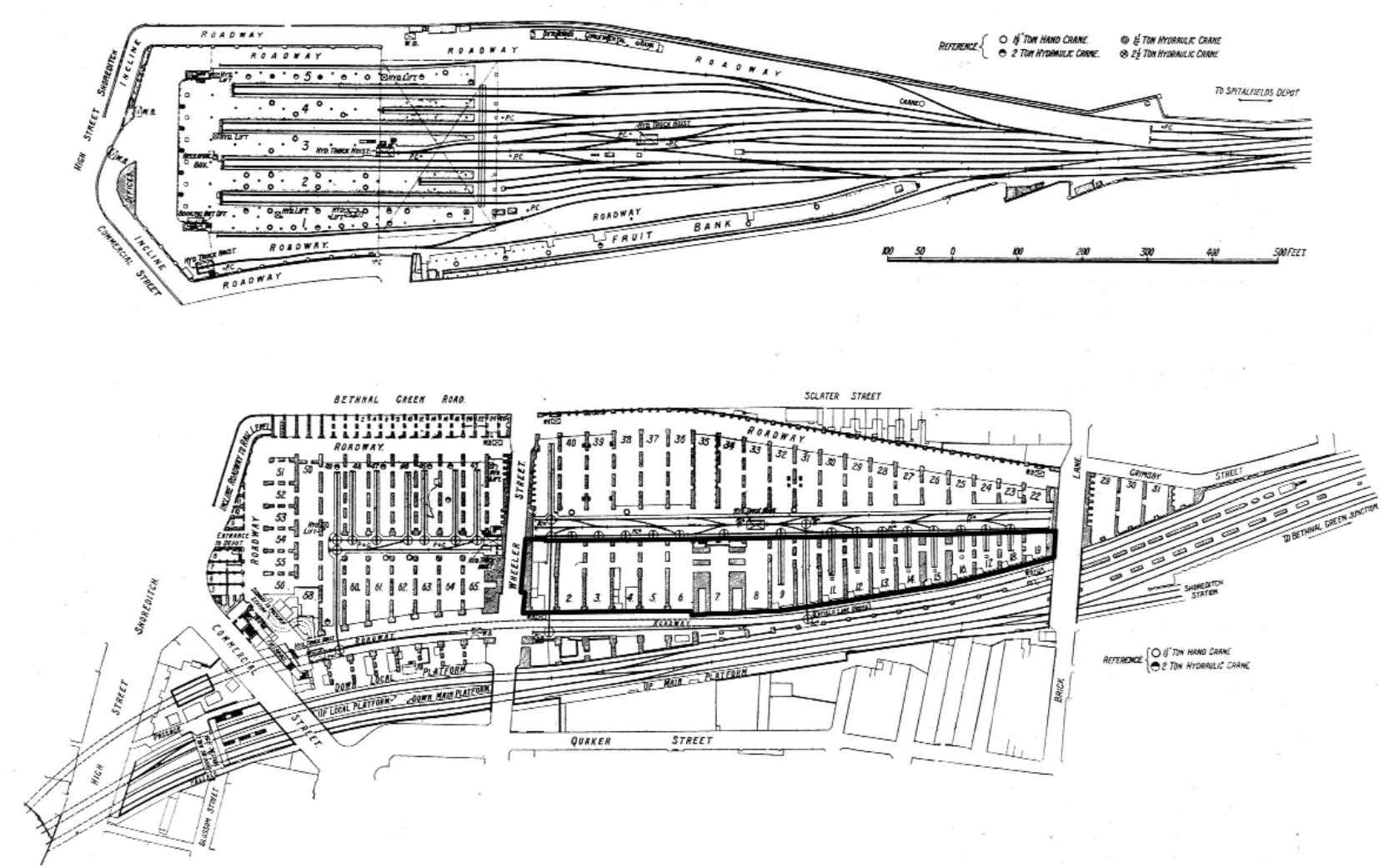
After I typed this I was able to find this diagram:
I think what was confusing me is that I wasn't imagine that two of the platforms were an island platform. So it appears that Down Local (side), Up Local (island), and Down Main (island) were between Commercial and Wheeler, and that the Up Main (side) was east of Wheeler. BTW, which of these pair were the original platforms (Main or Local)?
While I have you attention, I've been looking at this diagram and multiple pictures of the whole station, but I've not been able to ascertain exactly how many levels the station had. Can you help me with this? So, you have the ground floor, then a second floor, but I'm confused about the inclined roadways for one. Which way were the two incline roads inclined (up or down)? It looks like a road ramps up from Wheeler on the southside, and that the road on the northside ramped up above Wheeler to the second level? What's confusing me is that the "ground" floor diagram seems to be showing a basement level, maybe? Speaking of which, how many levels were there below street level? Just one? I wish there was some kind of cut-away diagram to show the site vertically. --Criticalthinker (talk) 07:47, 14 April 2020 (UTC)[reply]
Reading the article I would say the platforms on the mains (through) opened first. Despite the common name I don't think the high and low level stations were linked (in terms of passengers being able to change) even when the stations were briefly operating in parallel. Could be wrong but the passenger went to one or the other, and when Liverpool Street opened, high level closed.I cannot answer your question on levels with certainty - however this article may help? https://www.subbrit.org.uk/sites/bishopsgate-goods-station/--Davidvaughanwells (talk) 20:40, 21 April 2020 (UTC)[reply]
The link your provided doesn't work, but I have read the page for this on SubBrit. And in fact I was asking because it may have been a bit TOO wordy and detailed, because I didn't come away with a clear answer of the various levels of the station. It's a shame there aren't many good close-up shots of the station from its working days. --Criticalthinker (talk) 14:28, 23 April 2020 (UTC)[reply]


