
Talk:Control of cities during the Syrian civil war/Archive 19
| This is an archive of past discussions. Do not edit the contents of this page. If you wish to start a new discussion or revive an old one, please do so on the current talk page. |
| Archive 15 | ← | Archive 17 | Archive 18 | Archive 19 | Archive 20 | Archive 21 | → | Archive 25 |
Sousiyan (Northern Aleppo)
This edit request to Template:Syrian Civil War detailed map has been answered. Set the |answered= or |ans= parameter to no to reactivate your request. |
Pro-opposition source claiming IF forces took control of several villages east to Al Bab including Sousiyan.link, I don't really believe someone from ISIS will write about that, i dont even know how to find them.
92.36.221.103 (talk) 23:38, 11 June 2014 (UTC)
Yea, still waiting on an ISIS or Kurdish or Regime or Neutral source for validation/refutation of this claim. Can't edit without until that time. Boredwhytekid (talk) 23:46, 11 June 2014 (UTC)
 Not done: please establish a consensus for this alteration before using the
 {{edit semi-protected}}template. Per Boredwhytekid. Thanks, Older and ... well older (talk) 19:46, 12 June 2014 (UTC)
Abuserre
Abuserre (with its eastern hills) is and has been now for a while under YPG control. This video shows that pro-YPG FSA groups (i.e. FSA groups that are armed and supported by YPG) passing by a YPG checkpoint at Abuserre. At 00:49 the entry sign to Abuserre is visible. Between 00:59 and 01:02 the hanging flag of YPG is visible. Moreover, a certain user has reverted my recent good edits. Roboskiye (talk) 22:11, 8 June 2014 (UTC)
The problem is that the new editors insist to not use reliable sources as SOHR and Hawarnews,and to only use when an opposite source admits the advance of the other.Alhanuty (talk) 12:26, 9 June 2014 (UTC)
- Actually not all advancements are mentioned by opposite sources. This basically means a large portion of important info is simply ignored.
- I'd like to mention that the village of Xerab Ishk, south of Kobanê is under YPG control. Roboskiye (talk) 20:49, 9 June 2014 (UTC)
It doesn't matter if the sources are reliable. If the source shows regime advance, the editors will make sure to update the map right away. If the source shows rebel advance, they will 'monitor the situation' for several weeks/months, or if you have a source from SANA stating rebel advance (they always report on this issue very fairly), then we can add it. — Preceding unsigned comment added by 213.204.106.22 (talk) 04:08, 10 June 2014 (UTC)
![]() Comment: - If you want, I could start using NDF or SAA-shot videos to back their claims, would you like that and accept it? Try to be a little professional, please...--HCPUNXKID 14:11, 10 June 2014 (UTC)
Comment: - If you want, I could start using NDF or SAA-shot videos to back their claims, would you like that and accept it? Try to be a little professional, please...--HCPUNXKID 14:11, 10 June 2014 (UTC)
- PunxKid: Your edits are too biased to be considered anything near funny. You provide an ultra-biased turkish link (such as haberler.com) to back your anti-Kurdish claims. Not only Yarubiya (Tel Kocher) is under firm YPG control, but even the opposite side of the border point (Rabia) is under Peshmarga control after Iraqi army fled from the whole region: (Link). Also you talk about SAA videos; but then what about FSA videos??? I previously provided a video showing YPG in control of Abuserre, your bias did not accept it. Now here are some other videos for FSA being in control of localities north and west of Raqqa: Video 1 & video 3. Roboskiye (talk) 20:17, 10 June 2014 (UTC)
- Look who's talking now about biasedness, the one who always give only kurdish or pro-armed opposition "media" links, never a neutral source. Again, review the agreement we have here and try to understand that you cannot use a kurdish source for backing a kurdish advance, gain, etc... Same with opp, same with gov, same with ISIS. Its not me who made that rule, so if you dont like it that's not my problem, dude...And about the video it seems you dont get the sarcasm, as unprofessional is accepting SAA, NDF or Hezbollah videos as proof of something as accepting YPG, IF, ISIS or FSA videos. Neither are reliable, as they could record them and later simply leave the site.--HCPUNXKID 23:15, 10 June 2014 (UTC)
- So according to your argument and contributions one cannot use a Kurdish source for backing a Kurdish advance, but 'one can use an anti-Kurdish source for backing rumors of Kurdish loses'?! Is'nt this funny?! Roboskiye (talk) 14:37, 11 June 2014 (UTC)
- Are you able to understand that its not me who made the rules? And finally, are you aware that I dont use an anti-kurdish source to put the town and border crossing in black, but instead I took 2 sources, an (according to you, Im not an expert on turkish media so I dont know if that source is anti-kurdish or not) anti-kurdish source & a pro-kurdish source, and due to the contradiction on what they report I made an equitable decision between the 2 reports. Perhaps you would feel better if I had accepted the pro-kurdish one and denied the turkish one, but thats not how WP works, unless you want to made this an agit-prop blog, wich it seems to be what many editors (both pro-opp & pro-gov) here want...--HCPUNXKID 22:10, 11 June 2014 (UTC)
- So according to your argument and contributions one cannot use a Kurdish source for backing a Kurdish advance, but 'one can use an anti-Kurdish source for backing rumors of Kurdish loses'?! Is'nt this funny?! Roboskiye (talk) 14:37, 11 June 2014 (UTC)
- Look who's talking now about biasedness, the one who always give only kurdish or pro-armed opposition "media" links, never a neutral source. Again, review the agreement we have here and try to understand that you cannot use a kurdish source for backing a kurdish advance, gain, etc... Same with opp, same with gov, same with ISIS. Its not me who made that rule, so if you dont like it that's not my problem, dude...And about the video it seems you dont get the sarcasm, as unprofessional is accepting SAA, NDF or Hezbollah videos as proof of something as accepting YPG, IF, ISIS or FSA videos. Neither are reliable, as they could record them and later simply leave the site.--HCPUNXKID 23:15, 10 June 2014 (UTC)
- Just make us a favor and don't pretend you're a neutral buddy, editing for science's sake! Don't accuse me of being biased just because exclusively editing towns located north of Syria; the reason being because the region is geographically within Kurdistan. For your info I've added pro-gov cities: Safira, Ariha Ayn Isa etc, Pro-FSA sources (some of which you removed), Jihadi towns (Shar Karak, and some other north of al-Bab). So you don't have a point here. I'm tired, just back from work and cannot put more energy on this for the moment. Roboskiye (talk) 20:34, 12 June 2014 (UTC)
- PunxKid: Your edits are too biased to be considered anything near funny. You provide an ultra-biased turkish link (such as haberler.com) to back your anti-Kurdish claims. Not only Yarubiya (Tel Kocher) is under firm YPG control, but even the opposite side of the border point (Rabia) is under Peshmarga control after Iraqi army fled from the whole region: (Link). Also you talk about SAA videos; but then what about FSA videos??? I previously provided a video showing YPG in control of Abuserre, your bias did not accept it. Now here are some other videos for FSA being in control of localities north and west of Raqqa: Video 1 & video 3. Roboskiye (talk) 20:17, 10 June 2014 (UTC)
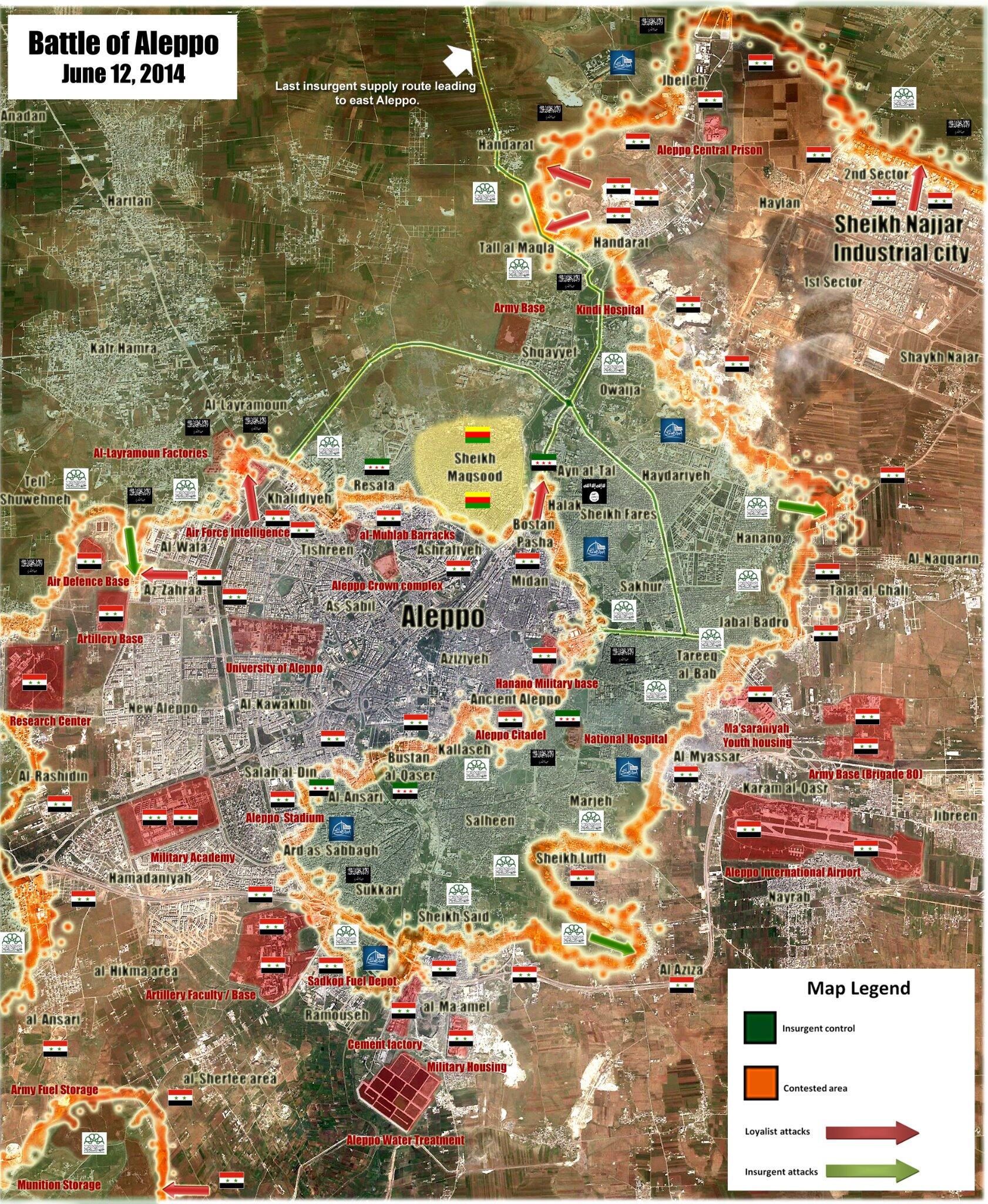
New Map Aleppo
Is pro regime but credibility is good. https://pbs.twimg.com/media/Bp8esZ-IgAAbko1.jpg:large — Preceding unsigned comment added by LogFTW (talk • contribs) 19:51, 12 June 2014 (UTC)
- Yea this is the syrianperspective map from last month - so, can be used for rebel positions. Boredwhytekid (talk) 19:56, 12 June 2014 (UTC)
Its from yesterday. http://www.syrianperspective.com/2014/06/updated-battle-map-of-aleppo.html — Preceding unsigned comment added by 83.92.120.157 (talk) 14:04, 13 June 2014 (UTC)
- Retract my above - confused it w/the May map from same source. — Preceding unsigned comment added by Boredwhytekid (talk • contribs) 16:09, 13 June 2014 (UTC)
Semi-protected edit request on 13 June 2014
This edit request to Template:Syrian Civil War detailed map has been answered. Set the |answered= or |ans= parameter to no to reactivate your request. |
Please change Til Kocer (Al Yaarubia) and the border crossing from contested to Kurdish controlled via: http://en.firatajans.com/news/news/til-kocer-rabia-border-is-under-control-of-ypg.htm and http://article.wn.com/view/2014/06/12/US_eyes_new_aid_to_Iraq_to_curb_insurgent_march_o9/ NadaCambia (talk) 15:38, 13 June 2014 (UTC)
- Not done: The two name you mention do not show up in a search of the map or of the text of the article. When you use the {{edit semi-protected}} template, you need to detail the exact change you would type in if you had edit privileges for the page in question. I think your request is at a higher level and requires editors knowledgeable about this page to implement. Thanks, Older and ... well older (talk) 16:53, 13 June 2014 (UTC)
Deir Ezzor under ISIS siege
Several sources (for example:this, this, this or this) state that Deir Ezzor is under ISIS siege. Should we put a black circle around Deir Ezzor or what?.--HCPUNXKID 14:13, 12 June 2014 (UTC)
Only the rebel side/north side of the Euphrates is besieged, right? Not the gov't/south side. I agree that some sort of indicator should be added, maybe a semi circle? Idk, that's all you. On a different note, can you locate "Hashama region" as mention in these links: http://www.dailysabah.com/mideast/2014/06/12/isil-blocks-aid-into-syrias-oilrich-city http://www.aa.com.tr/en/world/343868--isil-militants-block-aid-into-syrias-oil-rich-city ? I've struck out so far.. Boredwhytekid (talk) 15:36, 12 June 2014 (UTC)
- Amendment, additional resource: https://www.zamanalwsl.net/en/news/5339.html Sidenote - this is a non-ISIS source stating that ISIS controls Al-Shulah — Preceding unsigned comment added by Boredwhytekid (talk • contribs) 14:19, 13 June 2014 (UTC)
- The source is pro-opp & as you said not pro-ISIS, but the map attached to the article is from a pro-ISIS media outlet. By the way, I brought here 2 maps from pro-opp & anti-ISIS sources stating that Al-Shulah is in ISIS hands, but some editors here disagreed on making that change, and I cant be fighting against pro-opp, pro-gov, pro-kurdish & pro-ISIS editors all the time...--HCPUNXKID 14:49, 13 June 2014 (UTC)
- I see. Well, that's nonsense. The two you brought - https://twitter.com/archicivilians/status/472791482726748160/photo/1 and https://pietervanostaeyen.files.wordpress.com/2014/06/20140602-000619.jpg are both anti-ISIS (or, not pro-ISIS), and so is https://www.zamanalwsl.net/en/news/5339.html from yesterday. There is no recent, credible indication that the SAA is there. This report http://www.understandingwar.org/sites/default/files/ISWBackgrounder_Valerie%20ISIS_Deir-ez-Zour.pdf spoke of ISIS and Nusra battling/skirmishing in the area a while ago too. I'm not pro-anything but clarity/reality - ISIS controls it; I'm editing it. Boredwhytekid (talk) 16:04, 13 June 2014 (UTC)
- Also, the map https://twitter.com/CdricLabrousse/status/470534599479943168/photo/1 that was cited in argument against you - look at the roads and compare them to the location of Al-Shulah on wikimapia - specifically note the geographic features/color tones - even Labrousse's map indicates that Al-Shulah is under ISIS control! — Preceding unsigned comment added by Boredwhytekid (talk • contribs) 16:19, 13 June 2014 (UTC)
I do not think ISIS has the operational capacity / enough fighters for made a effective siege on Deir Ez Zor area, they fighting others insurgents, Iraqi Army and Kurdish insurgents too, others rebels claim ISIS are regime allied and share territories (But they did same claims before with Kurdish insurgents)
They can cut paved roads but alternative routes in the desert will always be available.
Anyway that is my opinion only. — Preceding unsigned comment added by LogFTW (talk • contribs) 18:58, 13 June 2014 (UTC)
I agree - that's my opinion too - but look at how they are faring against the Iraqi forces, 9 years trained, $25 billion invested, 1,000,000 strong... Also, to besiege rebel-held Deir Ezzor ISIS would simply have to control the north bank of the Euphrates http://www.dailystar.com.lb/News/Middle-East/2014/Jun-13/260017-activist-says-jihadis-besiege-eastern-syrian-city.ashx#axzz34YDZr4iL [User:Boredwhytekid|Boredwhytekid]] (talk) 19:44, 13 June 2014 (UTC)
Something about water
By the way. The water surfaces are useful BUT there are none in the Syrian Desert. I don't know why such were added! Remove them please and adjust according to the following:
Keep the one by Al-Sfayrah which is called Sabkhat Al Jabbul. (It is important as the boundary between control areas. Add Al-Rastan Lake (It's the reason the militants are secure (but also isolated) to the north of Hims. You can keep Qattinah Lake by Hims city - it's one of the only few lakes in Syria. Add Al-Khabour River in North East, and the river towards Raqqah.
this here is precipitation but not actual lakes or anything https://www.google.com/search?q=rivers+in+syria&rlz=1C1KMZB_enUS576US576&espv=2&source=lnms&tbm=isch&sa=X&ei=686LU-rFNNawoQTdnoGAAg&ved=0CAcQ_AUoAg&biw=1242&bih=607#facrc=_&imgdii=_&imgrc=sy4CyIp-VWpv8M%253A%3BJ3U0fjAbkySxNM%3Bhttp%253A%252F%252Fwww.geographicguide.com%252Fpictures%252Fmaps%252Fmap-syria.jpg%3Bhttp%253A%252F%252Fwww.geographicguide.com%252Fasia%252Fmaps%252Fsyria.htm%3B1260%3B962 ! — Preceding unsigned comment added by 98.224.15.164 (talk) 01:14, 2 June 2014 (UTC)
![]() Comment: - Agree on some things with the unsigned user above. Two important rivers must be added to the map: the Khabur river (Hasakah & Deir Ezzor governorates) and the Orontes river (Homs, Hama & Idlib governorates). And again, please add at least the Aleppo-(Idlib)-Hama-Homs-Damascus-(Daraa) expressway, wich is the main road of the country.--HCPUNXKID 15:50, 2 June 2014 (UTC)
Comment: - Agree on some things with the unsigned user above. Two important rivers must be added to the map: the Khabur river (Hasakah & Deir Ezzor governorates) and the Orontes river (Homs, Hama & Idlib governorates). And again, please add at least the Aleppo-(Idlib)-Hama-Homs-Damascus-(Daraa) expressway, wich is the main road of the country.--HCPUNXKID 15:50, 2 June 2014 (UTC)
![[1]](http://www.geographicguide.com/pictures/maps/map-syria.jpg)
Thank you admin for making some of the changes.
Need to add the Balikh River (between Tal-Abyad and Al-Raqqah) it dectates almost all civilian centers in that stretch of land. Need to add Orontes rivers between Lebanon and Turkey, and Al-Rastan Lake (very significant as the barrier between militants and government areas). Here is an example of it http://s1070.photobucket.com/user/amaraen1/media/RastanHoulaEnclaveFront-3.jpg.html Need to add Al-Khabour all the way to Euphrates River (it dictates the locations of almost all civilian centers in that area). Also as previous comment: There is actually no lake or any body of water (Rawda) directly east of Dair-Alzor; his was a seasonal puddle in heavy rain seasons.
If you do these, I think you'll have it perfect. — Preceding unsigned comment added by 76.127.127.203 (talk) 04:09, 3 June 2014 (UTC)
Great additions of the rivers. You could correct the Orontes river between Gantu an Al-Rastan, it runs different than depicted, and Just include Al-Balikh river between Turkey and Al-Raqqah. Done — Preceding unsigned comment added by 76.127.127.203 (talk) 08:12, 14 June 2014 (UTC)
Abu al-Duhur air base not under siege anymore since mouths ago.
TV Reports from Syrians and Lebanese TV Channel inside this air base.
In this one you can see 5 Different TV Channel teams inside the air base -- > https://www.youtube.com/watch?v=68cyAiSrynk https://www.youtube.com/watch?v=14zPBAFRW7k https://www.youtube.com/watch?v=0D8q--kXesU
This source (The redaction sound Anti Syrian Government) Said from This air base doing 427 Sorties in 50 days only to North Hama area http://iswsyria.blogspot.com/2014/05/air-sorties-in-northern-hama-province.html
^ It not including Idlib and Aleppo including the sorties in these places must be 600+ , so is clearly a very active operative air base in no siege conditions — Preceding unsigned comment added by LogFTW (talk • contribs) 08:45, 5 June 2014 (UTC)
The iswsyria.BlogSpot source - provided by yourself - explicitly says in the third paragraph that Abu Duhur is besieged... Boredwhytekid (talk) 14:38, 5 June 2014 (UTC)
iswsyria.BlogSpot is a hard line a anti regime source there said in 2013 was at least under partially rebel control but not now..
Abu Duhur has been heavily besieged by rebels for well over a year, and was at one point at least partially under their control in April 2013. It has since reverted to full regime control
There just said Insurgents continue "Near the base" but obviously away their status is similar than Kweris air base in Aleppo not under siege but with ISIS near the area a base Under siege can't doing 600+ Sorties in 50 days - Remember the Siege to Menagh Air Base https://en.wikipedia.org/wiki/Siege_of_Menagh_Air_Base during the siege this place no was able for landing a single helicopter. — Preceding unsigned comment added by LogFTW (talk • contribs) 16:21, 5 June 2014 (UTC)
That half quote continues: "..it is no longer used for fixed-wing aircraft (likely too difficult to land safely with the rebels’ continued presence near the airbase)". As has been discussed here before, the circle does not necessarily indicate a siege in the conventional/Medieval sense of the term. Accordingly, the fact that the rebel presence on the outskirts/environs is significant enough to prohibit the use of fixed-wing aircraft at this facility warrants the green circle on this map. Boredwhytekid (talk) 16:32, 5 June 2014 (UTC)
^ It no carry fixed-wing aircrafts anymore since many time ago because very probable before the conflict based on Insurgents videos from April 2013 when place was under siege is visible a MiG-23 graveyard. Confirming planes on this base were inactive in no flying condition since a lot time ago. http://1.bp.blogspot.com/-qpoHQDr535g/UX-22BA6IQI/AAAAAAAAAXs/bjlqAqZVcn4/s640/msss.png
This information was publish in pro Rebel blog when they get happy believing the insurgents was almost with that captured. http://spioenkop.blogspot.com/2013/04/abu-ad-duhur-airbase-captured-by-fsa-1.html
6 different TV Channels doing a long trip inside the Base and some areas near it the place is safe for journalists Teams (Including International Journalists) and in TV reports are visible Lands vehicles in the perimeter of the base too..
The bases / Zones under siege only is possible assists troops inside With Air Droops Better Example the siege to Menagh Air Base. — Preceding unsigned comment added by LogFTW (talk • contribs) 17:29, 5 June 2014 (UTC)
True, it is not completely isolated or being stormed or constantly bombarded. But, it is occasionally shelled, and this link https://www.youtube.com/watch?v=ZnPPKTnY2Ms - cited from the iswsyria source - shows that opposition forces are in the immediate vicinity, targeting the traffic of al-Duhur. Again, the circle does not indicate a siege in the conventional sense; the base may not be in existential danger, but nonetheless, the green circle is the closest indicator of the actual ground situation. Boredwhytekid (talk) 18:15, 5 June 2014 (UTC)
All evidences suggests since mouths ago Abu al-Duhur Air Base it's not under siege =
- 600 + Sorties from this base in 50 days according to Anti regime sources
That reflecting a clear high operative level in this base is more active than Raqqah Airport.
- Six TV Channels including international TV teams inside the base doing a trip there and nearby areas.
- Videos from Insurgents in this place are a way less usual that before and more far away.
- Insurgents focus in others zones in Idlib and West and South of Aleppo no in this Air base
Anyway if for some people who support the insurgents is a physiological boots keep it under siege I no have problems to keep it in Green so Abu al-Duhur town near the base still under Insurgent control .. But since mouths ago in this base no exist a siege with the characteristics usual in this conflicts = Suicide Trucks, Tunnels Bombs etc — Preceding unsigned comment added by LogFTW (talk • contribs) 00:53, 6 June 2014 (UTC)
- It seems that you don't understand what "siege" means : that access by ground is not possible, and the area controlled is relatively small. The fact that planes can't take off/land just reinforces the fact that it is under siege. In northern Ragga, brigade 93 has been under siege (until recently) but helicopters could always take off and land. (Although it could have been risky if rebels had better weapons. But better weapons would probably have let them take the base.)
- Note also that the regime controls only part of the city south of the river.
- As well, as others have pointed out, a circle around is sometimes used to indicate opposing forces in close proximity, presenting a real danger. André437 (talk) 08:05, 15 June 2014 (UTC)
Al-Shaddadi Al-Hawl & Tal hamis
These cities are contested by this source :http://fa.alalam.ir/news/1602896 this source is persian language you can translate it by Google translate.MZarif (talk) 09:34, 15 June 2014 (UTC)
An-Nabaeen city
This city is under the control of SAA: http://www.almayadeen.net/news in recent news part MZarif (talk) 15:31, 14 June 2014 (UTC)
Confirmed by SOHR [2]. EkoGraf (talk) 19:11, 14 June 2014 (UTC)
Apparently Kassab is also been taken by SAA (from twitter). Official confirmation is expected soon. 79.21.132.164 (talk) 21:34, 14 June 2014 (UTC)
Al Mayadeen is a pro-regime source.
Furthermore, if we are still "awaiting confirmation", why has Kassab already been made red?
The bias in this map is getting stupid. — Preceding unsigned comment added by 213.204.106.13 (talk) 01:06, 15 June 2014 (UTC)
A pro opp source that confirms that the rebels had withdrawn from Kessab
http://akhbar.alaan.tv/news/post/33034/nusra-front-free-syria-army-withdraw-kasab (Ali bachir (talk) 07:59, 15 June 2014 (UTC))
The recent news confirm that "Naba'al Murr city" is under the control of SAA: http://www.almayadeen.net/news in recent news partMZarif (talk) 09:56, 15 June 2014 (UTC)
Naba'al Murr city
The recent news confirm that "Naba'al Murr city" is under the control of SAA: http://www.almayadeen.net/news in recent news part.MZarif (talk) 16:03, 15 June 2014 (UTC)
Confirmed by SOHR. EkoGraf (talk) 17:51, 15 June 2014 (UTC)
Correction
This edit request to Template:Syrian Civil War detailed map has been answered. Set the |answered= or |ans= parameter to no to reactivate your request. |
Correction, Um Sharshouh in Homs under regime control and Kharata oil field in Deir ezzor and Mamurah in Qalamon under opposition control. 83.110.100.100 (talk) 10:46, 15 June 2014 (UTC)
- You can provide the source which can confirm your data. Hanibal911 (talk) 11:40, 15 June 2014 (UTC)
- [www.facebook.com/syriahroe/posts/542079225900420 SOHR] reports Um sharshouh under SAA control. The oil field Sha´r under SAA control as well but I do not know where it is. Paolowalter (talk) 17:28, 15 June 2014 (UTC)
- Another pro opposition source confirms that the army captured the village of Umm sharshouh.War Science Hanibal911 (talk) 18:00, 15 June 2014 (UTC)
- Can I take it that you are updating this? Older and ... well older (talk) 18:25, 15 June 2014 (UTC)
- Another pro opposition source confirms that the army captured the village of Umm sharshouh.War Science Hanibal911 (talk) 18:00, 15 June 2014 (UTC)
Rankous
This article http://news.yahoo.com/why-isis-gains-iraq-reshaping-syrias-regimes-war-154413826.html is from today, and quotes a "Hezbollah combatant" as saying that there is fighting on the outskirts of Rankous, Qalamoun. Boredwhytekid (talk) 16:44, 16 June 2014 (UTC)
- But that is no reason to change the status of the city. Because this is their usual tactics attack the army position on outskirts the city and retreat. Hanibal911 (talk) 17:46, 16 June 2014 (UTC)
I agree - just something to keep an eye open for. Boredwhytekid (talk) 17:58, 16 June 2014 (UTC)
- In this I agree with you so we need to monitor this situation. Hanibal911 (talk) 18:35, 16 June 2014 (UTC)
Another pop up: http://www.dailystar.com.lb/News/Analysis/2014/Jun-16/260266-isis-iraq-offensive-could-trigger-hezbollah-to-fill-gap-left-in-syria.ashx#axzz34pQRwmNY Boredwhytekid (talk) 18:36, 16 June 2014 (UTC)
Two media outlets purporting to cite SOHR rebels "claimed the takeover of the village of Aasal al-Ward". Both source use the same phrase - "claimed" - so no edit yet, but another one to watch http://www.dailystar.com.lb/News/Middle-East/2014/Jun-16/260284-syrian-regime-forces-retake-kasab-pound-isis-bases.ashx#axzz34pQRwmNY http://us.newshub.org/syrian_regime_forces_retake_kasab_pound_isis_bases_1331586.html and another http://eaworldview.com/2014/06/syria-daily-insurgents-attack-jobar-damascus/ still no confirmation though, but the rumor mill is a churning. [User:Boredwhytekid|Boredwhytekid]] (talk) 18:58, 16 June 2014 (UTC)
About situation in the city of Rankus both sources said about the attack rebels outside the city that as I said earlier can not be the basis for changing the status of the city Rankus. Also about the situation in the village of Aasal al-Ward in the source is clearly stated that it only affirmation of the rebels and there is not more evidence for this assertion. A source Ea Worldview is a pro opposition source and can not be used to display the progress of the rebels. Hanibal911 (talk) 20:22, 16 June 2014 (UTC)
- Yup. No argument here. Boredwhytekid (talk) 20:28, 16 June 2014 (UTC)
Deir ez-Zor city map
The Deir ez-Zor city map needs to be modified. All territory north and east across the river from the city is ISIS-controlled [3][4]. EkoGraf (talk) 20:35, 17 June 2014 (UTC)
al-Shulah
SorenC ! - this is a pro-opp/anti-ISIS source stating ISIS in control of al-Shurah https://www.zamanalwsl.net/en/news/5339.html And here are two more non-ISIS sources https://twitter.com/archicivilians/status/472791482726748160/photo/1 https://pietervanostaeyen.files.wordpress.com/2014/06/20140602-000619.jpg And here is Cedric Labrousse's map - and we all know he is pro-rebels and not pro-ISIS https://twitter.com/CdricLabrousse/status/470534599479943168/photo/1 . These all show that al-Shurah has long since fallen to ISIS - provide a more recent, credible source or stop the POV pushing reverts. Boredwhytekid (talk) 13:15, 17 June 2014 (UTC)
I won't revert any further. But we need to discuss this policy. For example: If a pro-goverment source reported all ISIS areas in the whole of Syria as captured by the YPG, according to this logic, that would mean we should have to change the map accordingly. My stance is that we need a neutral source OR a pro-"Fraction X" admitting a loss of "Fraction X" before we can make any changes. Looking forward to hear what the Wiki community says about this point. SorenC (talk) 15:34, 17 June 2014 (UTC)
^ This map who you are showing from Labrouse (May 17) showing al-Shulah under Army control - Read well when said "Alternative loyalist road to Deir Ez Zor" in fact this was used (Before) for keep al-Shurah in red. https://twitter.com/CdricLabrousse/status/470534599479943168/photo/1
There is another map from June 15 Most recent source atm (Seems neutral) and showing al-Shulah is under Army control http://umap.openstreetmap.fr/fr/map/desyracuse-syria-civil-war-15-june-2014_10660#12/35.2113/39.9150
This map https://pietervanostaeyen.files.wordpress.com/2014/06/20140602-000619.jpg is created by FSA fanboy https://twitter.com/arabthomness he is just trolling. — Preceding unsigned comment added by LogFTW (talk • contribs) 15:46, 17 June 2014 (UTC)
With the above comments in mind, shall we put the town in contested? SorenC (talk) 10:41, 18 June 2014 (UTC) I did read well; I reviewed the last discussion about al-Shulah. Check out the Labrousse map more thoroughly. It is based off of wikimapia - put the two side to side. Labrousse's map very clearly shows al-Shulah NOT on that "alternative loyalist road". Focus on the geographic features and color distinctions - it's really easy to see.
SorenC - I completely agree that the policy is flawed. However, pro-government outlets NEVER publicize loses/setbacks (nor do most sides but that's not the point). And we're not relying on ISIS's word here either. Labrousse is about as pro-op as it gets, and he's showing al-Shulah in black; https://www.zamanalwsl.net/en/news/5339.html is neither pro-gov't nor pro ISIS, and they are reporting it the same. I get that there's no such thing as a neutral source in the conflict, but those two sources don't support either side that is allegedly contesting/controlling the place. Haha you're completely right in your example; technically speaking by the rules of this map we'd have to discuss making that change. But I'd like to think that the farfetched nature of such a claim would be self evident. Let's hope we don't have to cross that bridge..Boredwhytekid (talk) 16:10, 17 June 2014 (UTC)
Request to change names
Shouldn't the local names of villages, towns, cities in for example Kurdish be changed to the official name? Another solution would be to have both the official and the local name. For example: Kharab Nas (Xerabnas) --Ahmetyal (talk) 17:41, 17 June 2014 (UTC)
I agree, just remember to add all the Kurdish names so Kurdish sources are efficiently used. — Preceding unsigned comment added by 216.53.133.154 (talk) 12:41, 18 June 2014 (UTC)
Most recent Institute for Study of War map
For our purposes this is a pro-opp map/source. Just posting the resource, not pro-opp editing based on it. But it claims the opposition has seized towns from ISIS in Aleppo province, and it also supports claims of clashes in Rankous, Qalamoun. http://iswsyria.blogspot.com/2014/06/syrian-repercussions-from-iraq-crisis.html Boredwhytekid (talk) 13:32, 17 June 2014 (UTC)
- But this source describes the events in the city of Rankus for June 12 but other more newer and more reliable sources confirm that the clashes occur on the outskirts of the city.Yahoo NewsUS News HubThe Daily Star Hanibal911 (talk) 15:11, 17 June 2014 (UTC)
Indeed. Just posting the resource b/c they just put it up. Boredwhytekid (talk) 15:32, 17 June 2014 (UTC)
Dude Labrusse is more credible than the Pirate Study of War and dude they are pro Opssition http://www.liveleak.com/view?i=cc4_1379363256
The word "Regime" is used by Pro opposition sources only - Neutral Sources usually said Army or Government. — Preceding unsigned comment added by LogFTW (talk • contribs) 15:52, 17 June 2014 (UTC)
- Ya, hence why I identified it as pro-op in my very first sentence..Boredwhytekid (talk) 15:58, 17 June 2014 (UTC)
- I agree with the editor LogFTW because it is extremely doubtful source and not credible. Especially if his data belie a more reliable sources. Also I think that we do not generally should used as sources of data from the blogs and Facebook and also message in the Twitter. An exception can be maps that publish on Twitter because many editors have previously agreed to use them in as a source. Hanibal911 (talk) 16:13, 17 June 2014 (UTC)
Do you guys not read well? I said, PRO-OP MAP. NOT USING IT FOR ANY PRO-OP EDITING. Haha geez oh man.. I agree with both of you! Boredwhytekid (talk) 16:24, 17 June 2014 (UTC)
- I'm sorry buddy! did not pay attention. Hanibal911 (talk) 16:44, 17 June 2014 (UTC)
LOL kk — Preceding unsigned comment added by LogFTW (talk • contribs) 17:33, 17 June 2014 (UTC)
Honestly you (may we) are paying too much attention to map published by whoever is willing to put one the web. We should consider if some of the guys who produce the maps mentioned above has access to some info that we do not have. According to our info from RS that we reviewed in the past, al-Shulah is red and can be changed only on the basis of another RS. Independent of being pro-opp or pro-gov or else, I wonder why the above maps should be considered more robust that ours. Some of the map producers like AC or SP have contact on the ground but the others are just patching info, definitely worse than we do. I am sure that non ob the above map-producer has any idea of who is controlling al-Shulah.Paolowalter (talk) 21:21, 17 June 2014 (UTC)
But, that's what we do, right? Search, and filter. Ours is only "robust" because of our combined energies to look at and vet all of the information that hits the web. Yea, there are independent map-makers that produce uninformed pieces - absolutely. As goes al-Shulah, the change wasn't exclusively based on an independent map though (granted, some of the sources are of more questionable validity than others); but on the most recent pro-op map(s) supplemented by (relative to al-Shulah) a neutral news source as well. Boredwhytekid (talk) 14:25, 18 June 2014 (UTC)
Tell Brak.
Here's anotherstranger situation in the city of Tell Birak in the province in Hasaka which at the beginning of the year the Kurds recaptured from ISIS and then handed over control of the city to the hands of local tribes but in the article the pro-opposition Kurdish source said that the city of Tell Birak is under control of ISIS and that they therethrough send reinforcements and equipment from Iraq. Source also said that the city of Hulu also under the control of ISIS.Ara News Who can explain the situation to these cities. Hanibal911 (talk) 21:02, 16 June 2014 (UTC)
- Odd. I couldn't find a Kurdish mention of ISIS returning - just the article when they had been expelled http://aranews.net/2014/03/kurdish-ypg-end-military-operations-in-syrias-tel-birak/ But, the link you - Hanibal911 - posted above does represent a Kurdish source reporting an ISIS advance.. and I doubt the Kurds are falsely claiming an ISIS advance.. so, valid for editing purposes..Boredwhytekid (talk) 12:39, 17 June 2014 (UTC)
- Source said that: On the other hand, several pictures and videos (posted online) showed ISIL-held armoured vehicles brought to the areas under its control in the Hasakah province, passing through towns ofTel Hamis, al-Hol and Tel Birak.Ara News I dont claim that the city of Tal Brak under the control of ISIS I just want clarify the situation with this city. Hanibal911 (talk) 12:59, 17 June 2014 (UTC)
![]() Comment: - As sources (a kurdish news report & a pro-kurdish map) state that Tell Brak is held by a local council, I made that change, adding a blue dot as symbol.--HCPUNXKID 16:00, 18 June 2014 (UTC)
Comment: - As sources (a kurdish news report & a pro-kurdish map) state that Tell Brak is held by a local council, I made that change, adding a blue dot as symbol.--HCPUNXKID 16:00, 18 June 2014 (UTC)
Inkhil
Why is Inkhil red? SAA never took it at my knowledge and there are frequent mention of clashes e.g. on SOHR. Maybe was a mistype? It should be contested as used to be.Paolowalter (talk) 22:44, 18 June 2014 (UTC)
i have realized that during the last three monts that some rebel gains are reverted without a source,like qasr abu samra,um sharshouh with a single source ,and finally inkhil,those who are reverting without a source should be warned to stop,or else they should be reported for vandalism,and POV,i suggest a new rule,that any revert should e via reliable source.Alhanuty (talk) 00:30, 19 June 2014 (UTC)
The rule exists already and is generally applied. um sharshouh was changed to red based both on SOHR www.facebook.com/syriahroe/posts/542079225900420[] and http://www.documents.sy and SANA. For a small village one source is enough. As to qasr abu samra, I do not know. For Inkhil I'll turn it back to contested as proofed by many recent reports on SOHR and others sources. Paolowalter (talk) 12:24, 19 June 2014 (UTC)
Here confirmation from the pro opposition source that village Umm Sharshuh under army control.source Hanibal911 (talk) 13:57, 19 June 2014 (UTC)
- 1 it's twitter; 2 "some" activists; 3 "(unconfirmed yet)". Flaky at best..no? Boredwhytekid (talk) 14:44, 19 June 2014 (UTC)
so by this conversation we conclude that inkhil is contested and qasr abu samra is still rebel held.Alhanuty (talk) 14:41, 19 June 2014 (UTC)
Pro opposition source SOHR also confirmed that the village of Umm Sharshoh under army control.SOHR Hanibal911 (talk) 14:51, 19 June 2014 (UTC)
- touche — Preceding unsigned comment added by Boredwhytekid (talk • contribs) 14:57, 19 June 2014 (UTC)
- But i agree that status of the village Qasr abu Samra was changed without specifying the source which could confirm that this village under control of the army. Hanibal911 (talk) 14:59, 19 June 2014 (UTC)
But since we agreed not to use data from Twitter and from Facebook. Here is confirmation from a reliable source: Syria, army units also recaptured the village of Um-Sharshouh.Albawaba Hanibal911 (talk) 15:12, 19 June 2014 (UTC)
Basiyra; al-Ra'ii
Now, LogFTW and Hanibal911, don't kill me here :] - DISCLAIMER: THIS IS A PRO-OP SOURCE NOT TO BE USED FOR PRO-OP EDITING OR ANY EDITING BASED EXCLUSIVELY ON ITS CLAIMS. That being said, according to http://iswsyria.blogspot.com/2014/06/isiss-second-front-in-syria.html Basiyra is contested, and al-Ra'ii, Aleppo province is ISIS controlled and needs to be added (http://wikimapia.org/#lang=en&lat=36.525908&lon=37.719214&z=15&m=b&search=al-Ra'ii). Boredwhytekid (talk) 16:33, 19 June 2014 (UTC)
- Here is another confirmation that in the city Basira go clashes ISIS militants vs rebels.ISIS-rebel clashes resume in Deir al-Zor Hanibal911 (talk) 17:31, 19 June 2014 (UTC)
Al Hurra
The village of Al Hurra in al-Ghab area in the countryside of Hama under government control.NaharnetXinhuaSky News Hanibal911 (talk) 21:05, 20 June 2014 (UTC)
Reply for the stupid guy who just ignored the facts he don't want to edit
This edit request to Template:Syrian Civil War detailed map has been answered. Set the |answered= or |ans= parameter to no to reactivate your request. |
I dont mind to block me or not. I told you this has no credibility and you have to accept this. 83.110.100.100 (talk) 20:53, 20 June 2014 (UTC)
 Not done Stop creating unnecessary edit request. Your previous request has been denied. Please come up with a clear rationale and be civil in your approach. — LeoFrank Talk 03:57, 21 June 2014 (UTC)
Reply for the stupid guy who just ignored the facts he don't want to edit.
This edit request to Template:Syrian Civil War detailed map has been answered. Set the |answered= or |ans= parameter to no to reactivate your request. |
I am doing a fake the facts? Ok But stop saying this map is not PRO-Syrian Government map and you are ignoring all the facts that you don't like, and deleting the some city icons from the map because captured by ISIL or opposition, or go wipe you ass with this map. 83.110.100.100 (talk) 20:34, 20 June 2014 (UTC)
- You have not once tried to harm in this map Template:Iraq war detailed map until I turned to the admins that have banned edit her using only IP address. So now that you have decided to harm in this map. You vandal and your IP address must be blocked. Hanibal911 (talk) 20:42, 20 June 2014 (UTC)
Semi-protected edit request on 20 June 2014
This edit request to Template:Syrian Civil War detailed map has been answered. Set the |answered= or |ans= parameter to no to reactivate your request. |
New article from SANA (Syrian Arab News Agency) confirms the following information:
1- Villages around Jisr Al Shoghur: Ayn Soda, Bashlamon and Hiluz are all under insurgents control and were attacked yesterday by the SAA with mortars. So those villages are under insurgents control. 2- Villages in East Homs: Sultaniyah, Massadah and Khattab are all under ISIL control and were attacked by the SAA recently. So those villages are under insurgents control. 3- Clashes happened in Jayroud between SAA and insurgents, SAA seized some weapons during the clashes. 4- Al-Sa'an in North East Hama is contested area. (SANA published many news about this in the latest 5 days). 5- SAA attacked many insurgents were located in Tal Al Jabyah in Daraa. So Tal Al Jabyah under insurgents control.
source: http://sana.sy/ara/336/2014/06/20/551053.htm
Must update those edits to show more credibility. Thanks. 83.110.100.100 (talk) 20:01, 20 June 2014 (UTC)
- Stop inventing because in this source says nothing about the events in the province of Hama. Also in your source nothing said that the villages Sultaniyah, Massadah and Khattab under the control of ISIS. You you are doing a fake the facts. Hanibal911 (talk) 20:25, 20 June 2014 (UTC)
- And remember that for such major changes need confirmation from reliable sources. Hanibal911 (talk) 20:31, 20 June 2014 (UTC)
Syrian Kurdistan in Hands of Kurdish Insurgents border post no in conflict with ISIS
I THINK it COULD BE this border post who showing the map in conflict.
https://www.youtube.com/watch?v=XWzkR78tBM8 — Preceding unsigned comment added by LogFTW (talk • contribs) 17:16, 15 June 2014 (UTC)
- Yes it is Tel Kocher (Yarubiya). But there is biased contributor who even labels Rudaw as pro-YPG!! (sure he dows not know how often Rudaw critisizes PYD and that PYD does not regard Rudaw as a friendly news agency). BTW here are about a dozen of Arabic sources, neutral ones, pro-SAA, and pro-FSA ones all admitting Tel Kocher under YPG control:
- Roboskiye (talk) 03:47, 18 June 2014 (UTC)
- The only biased, POV-pusher partisan editor here is you, as you are always using pro-kurdish sources for kurdish gains, in blatant violation of the agreements we made here, so I will revert all them, wether you like it or not. If you dont like the rules we have here, a suggestion: Leave Wikipedia ASAP, you will not be missed here. If you had done this (giving not kurdish sources) days ago, there wouldnt be any problem. Oh, and also learn to read, I'd never said that Rudaw was pro-YPG, unless you are so silly to equate YPG=Kurds (anyone with a little knowledge knows that there are kurds opposed to YPG), because that's what I said, that Rudaw is a pro-kurdish source. I dont like to be as rude as this, but I cant stand with this type of internet warrior dummies...--HCPUNXKID 14:28, 18 June 2014 (UTC)
- Roboskiye (talk) 03:47, 18 June 2014 (UTC)
Hafez
ISIS seized control of the areas of Hafez and Muhassen in Deir al-Zor.The Daily Star Hanibal911 (talk) 17:29, 21 June 2014 (UTC)
New map of Deir-ez-Zor area from pro-gov source
There is this new map of the Deir-ez-Zor area from pro-government source [twitter.com/PetoLucem/status/480372429848854529/photo/1]. Some changes in the towns aroubd the city is likely to be necessary. Paolowalter (talk) 20:41, 21 June 2014 (UTC)
Tufayl, Lebanon
"Hezbollah, Syrian army surround Lebanese enclave" LINK--99.160.184.97 (talk) 08:45, 22 June 2014 (UTC)
Daraa countryside
The units of the army have continued advances in town Atman in Daraa countryside and gained control over al-Ghizlan, Qader al-Bitar and al-Qaser al-Ahmar farms.Al Jazeera Hanibal911 (talk) 07:41, 22 June 2014 (UTC)
Need to have the location for draw these places — Preceding unsigned comment added by LogFTW (talk • contribs) 22:28, 22 June 2014 (UTC)
Eskar, Maalal, Aleppo province
Report that these towns have been taken by ISIS. Iskar is on the map already - couldn't locate either on wikimapia though.. http://news.yahoo.com/syria-jihadists-now-using-humvees-seized-iraq-174644871.html Boredwhytekid (talk) 12:45, 23 June 2014 (UTC)
- On the map of Wikimapia he mistakenly marked as Kassar but on other maps Geo Names or Mapcarta he marked how Iksar necessary to correct this mistake on the Wikimapia. Hanibal911 (talk) 13:50, 23 June 2014 (UTC)
Syrian Army brigade 90 in Quneitra Governorate
Israel and pro FSA sources claim Israel military attacks positions in this Brigade under Syrian Army control http://news.nationalpost.com/2014/06/23/situation-tense-at-israel-syria-border-as-netanyahu-warns-against-any-retaliation-for-deadly-israeli-airstrikes/
I think it was before on map and some one delete it. — Preceding unsigned comment added by LogFTW (talk • contribs) 20:02, 23 June 2014 (UTC)
Kafrzita
This edit request to Template:Syrian Civil War detailed map has been answered. Set the |answered= or |ans= parameter to no to reactivate your request. |
Sorry for asking but i thought this town is fully under the SRF and Al Nusra control, not even contested since April. There have been several air raids by the SAA, including toxic gas usage. True i can't find pro-goverment sources but this is some map, i don't even know if pro-rebel or not, you decide arccivilianmap 92.36.219.144 (talk) 23:19, 21 June 2014 (UTC)
 Not done: it's not clear what changes you want to be made. Please mention the specific changes in a "change X to Y" format. — {{U|Technical 13}} (e • t • c) 22:28, 23 June 2014 (UTC)
Well change Kafrzeta to green
- Not done: please provide reliable sources that support the change you want to be made. — {{U|Technical 13}} (e • t • c) 00:03, 24 June 2014 (UTC)
SOHR cited via Daily Star - "Nusra merges w/ISIS at Albu Kamal"
http://www.dailystar.com.lb/News/Middle-East/2014/Jun-25/261528-nusra-front-pledges-loyalty-to-isis-activists.ashx#axzz35eciwQhi Boredwhytekid (talk) 12:44, 25 June 2014 (UTC)
http://ca.reuters.com/article/topNews/idCAKBN0F014M20140625 http://www.arabnews.com/news/592046 http://gulfnews.com/news/region/iraq/al-nusra-pledges-allegiance-to-isil-1.1352029?localLinksEnabled=false etc.. etc... Boredwhytekid (talk) 12:49, 25 June 2014 (UTC)
Make these news towns in east rural Hama could be against the rules
The source is that = https://twitter.com/archicivilians/status/479657968388956162/photo/1
But..
1) Source lacks of credibility is another FSA - Al Qaeda fanboy more for me it's not enough for showing that substantial map change.
2) According by the rules you need to have a source from specific town for draw one I do similar change before with towns in As-Suwayda Having many maps and changes reversed.
3) The twitter user who created the map said "It's not and not 100% accurate and information hard to found" https://twitter.com/archicivilians/statuses/479687797578551296
4) Other map created by FSA fanboy is obviously not credible but look totally different and put this same area in other non ISIS insurgents hands so both anti Government maps disagree at 100%.
5)This another map June 15 (Seem Neutral) https://twitter.com/deSyracuse/status/478169631921041410/photo/1 http://umap.openstreetmap.fr/fr/map/desyracuse-syria-civil-war-15-june-2014_10660#10/35.0204/37.4442 put showing these zones as unclear area probability share between Army / ISIS but still unclear
I no planing deleted these changes. But just saying, do no let SAA / FSA Fanboys no credible twitter accounts impose their wishes here. — Preceding unsigned comment added by LogFTW (talk • contribs) 23:25, 21 June 2014 (UTC)
Also worth to mention that SOHR mainly reports clashes around those villages with airstrikes mainly in the country side of the villages.There were no mention of rebels/ISIS taking control of the villages but the reports suggest hit and run attacks on army checkpoints which is way to short to mark this villages under opposition/ISIS control.Daki122 (talk) 12:35, 22 June 2014 (UTC)
sources confirm that rebels did recapture the region in late october 2013,also sohr confirmed airstrikes on the region,also a source reported isis commting abuses in sabura,and i don't think that the opposition force would be biased towards isis.Alhanuty (talk) 15:31, 22 June 2014 (UTC)
The SOHR Reported a "Alwai Family" was burned alive by ISIS in Zanuba (Saburra) was probability a bullshit from SOHR Ill explain you why
1) The SOHR support the US-EU /Gulf Monarchies backed insurgents Al Qaeda, FSA, Islamic Front their "activists" usually be these same Non ISIS Insurgents, the SORH "Activists Network" No works inside Syrian Army / ISIS so the SOHR it's not in the capacity for reported clashed / Fights / progress in these both factions.
2) The Syrian official Sources / Media SANA, Syria TV, SAMA TV, Al-Ikhbariyah no report combats or sectarian massacre doing by ISIS in this place (Syrian perspective are pro government bloggers they are not part of Syrian media) so according by Official Syrian Sources nothing happened in Zanuba.
3) Iranian / Lebanese media is pro Shiite media - Shiites are in conflict with ISIS since it was created years before the Syrian conflict star in 2010 they Shiites are in conflict with ISIS that is why the Iranian / Lebanese take the SOHR Claim about the alawi family burned alive in Zanuba as true, the Syrian regime it's not Shiite is Secular but Shiites supports them.
4) No evidences (Photos, videos, reports) from the ISIS assassination from this family in Zanuba the only evidence is the SOHR who is the machine war propaganda for the Insurgents who fight the Syrian and ISIS
5) Some insurgents and many anti Government twitters users claim ISIS is just the "First combat line of the Syrian Regime" - No evidences of Syrian Government - ISIS Links but one things is true the ISIS no fight the Syrian State since February 2014 - All reports from Mortars attacks, Car bombs, Tunnel bombs, executions of Soldiers reported by Syrian Media blamed the West backed Just see the map 4 Military bases are close or Inside from ISIS held territories and ISIS no attack these places since mouths ago.
6) In the zones when the US-EU /Gulf Monarchies are "Stronger" are places when ISIS no got activity (Israeli / Jordan borders, Idlib) in zones when are the ISIS is close or have activity (East Aleppo), Rural Homs the Syrian Army made substantial advances.
In easy words seems this claim from Alawi family killed by ISIS in Zanuba is just part of the SHOR communicational war against ISIS they no present evidences about this ISIS killing in Zanuba. — Preceding unsigned comment added by LogFTW (talk • contribs) 17:50, 22 June 2014 (UTC)
sources confirm that rebels did recapture the region in late october 2013, and SOHR than reported a month later in November that the Army recaptured that region following a counter-attack. EkoGraf (talk) 21:57, 22 June 2014 (UTC)
Actually SOHR reported airstrikes in the area https://www.facebook.com/syriahroe/posts/421309201310757.Alhanuty (talk) 22:59, 22 June 2014 (UTC)
- In the area wouldn't mean the town itself necessarily. There is also the surrounding countryside. EkoGraf (talk) 02:05, 23 June 2014 (UTC)
It clear says the city,eco,so the villages should be putted in black.Alhanuty (talk) 13:36, 23 June 2014 (UTC)
![]() Comment:
Comment:
- 1.If we are going to talk about credibility and biasedness, we can stop using maps from Arab Chronicle, Syrian Perspective, BBC, Archicivilians, Syracuse, etc...
- 2.The source (Archicivilians map) got specific towns named on it, and as its based on Wikimapia, towns not named can be clearly seen on the map on one zone or another. If we are going to talk about maps without names, we can talk about certain roads map, or about certain map with red towns not named south of Tabqa...
- 3. If you believe that any Syrian war map is 100% correct, you are very, very naïve (see for example the epic fails on BBC Syria maps)
- 4 & 5. Its laughable to call this source unreliable while trying to put this one as a "neutral" and moreover "reliable" source. Should I remember that this latter account had to reupload one of their maps less than 24 hours before the previous upload because of the several grave errors made on it? Not to mention the amateurism of that maps, made just of straight lines. So clearly, thats neither neutral neither reliable map source.
- 6.Finally, I know that the map source I brought is a pro-opposition one, but also a source as anti-ISIS as anti-SAA, and anyone with a little knowledge on Syria knows that nowadays the majority of the opposition is anti-ISIS (they wasnt in 2013, but we are talking about today), so source should be reliable in that aspect. Regards, --HCPUNXKID 23:22, 22 June 2014 (UTC)
This is not a matter about whether ISIS is part of the official opposition or not and whether they fight both them and Assad. ISIS is an anti-Assad group and we have a heavily anti-Assad source claiming gains for an anti-Assad group. Like it or not, ISIS is an anti-Assad group, inter-rebel conflict aside. And last confirmed information about the situation in that area was in November of last year when SOHR confirmed government forces recaptured it from the rebels. There were no reports of ISIS advances since than in that area and its highly questionable that all of a sudden ISIS is in control of that many villages. EkoGraf (talk) 02:10, 23 June 2014 (UTC)
Single map with a low credibility for me is not enough for made this huge ISIS substantial progress in Hama.
I think rules here are clear = Link 2 or more sources for made specifics changes towns by towns - Anyway I no planing reverting these changes, I'm just sharing my opinion and is this source is not enough at the moment for make these substantial ISIS gains on Syrian Army zones reported by Source who just six mounts ago were a ISIS lovers. — Preceding unsigned comment added by LogFTW (talk • contribs) 02:24, 23 June 2014 (UTC)
I agree with EkoGraf if indeed ISIS militants seized such a big territory in the Hama province then it the pro opposition source SOHR necessarily be reported about this. Hanibal911 (talk) 07:15, 23 June 2014 (UTC)
Let me tell you why I don't think those villages are not under ISIS control.First and only is that those villages are next to the main supply route to Aleppo meaning that if rebels/ISIS control them the government supply route would be cut meaning that would be big news which would have been reported by MSM. Clashes do occur in the area but mainly in the countryside as those villages are mainly aliwite and are very much loyal to the army which means we need more source that are reliable(even SOHR did not confirm that these villages are under rebel/ISIS control) and based on facts to change the situation.Daki122 (talk) 12:35, 23 June 2014 (UTC)
first this isn't big territory at all,and the supplyline from hama-athira-khanaser-aleppo does't go through these territory seized by ISIS.Alhanuty (talk) 13:39, 23 June 2014 (UTC)
Look at the map the road that comes out of Salamiya(that is the supply road that goes to Iritriya then Khanaser then Alepo) that goes right next to Zanubah and Qanfiz that is the supply road for Alepo.To point out that supply's don't come from Hama directly here is the actual supply road[5] As you can see the road passes right next to the towns that are said to be ISIS/rebel controlled or should I say they are a few hundred meters from the highway close enough to close it with sniper and ATGM fire.Daki122 (talk) 15:03, 23 June 2014 (UTC)
- We just must stop this absurd dispute since no one reliable sources not confirm that the ISIS rebels captured so many villages in the Hama province and make the editing on the map in favor of the rebels fighting against the Syrian army using data from the pro-opposition source it is nonsense and completely contrary to the rules which we have previously agreed to and will irresponsibly break them again, otherwise it will cause chaos in the editing. Hanibal911 (talk) 15:46, 23 June 2014 (UTC)
SOHR reported airstrikes in the region.so i would put all the villages contested.Alhanuty (talk) 19:39, 23 June 2014 (UTC)
- You must be joking. SOHR in their reports dont mention about the clashes in these villages but the very fact that the Syrian Air Force applied to air strikes in the area then this is not a reason to change these villages contested. In order to change status these villages need data from reliable sources which will indicate that there are clashes in these settlements which have been specified in the anti government source. Also Alhanuty you must be stop your unfounded statements. Hanibal911 (talk) 06:25, 24 June 2014 (UTC)
Some people talk before about the road from Hama / Homs to Aleppo the Army / NDF controlled this road since October 2013 http://en.alalam.ir/news/1522206 http://www.liveleak.com/view?i=6e5_1380449178 https://www.youtube.com/watch?v=7YJWfOM721Y http://www.islamicinvitationturkey.com/2013/10/03/syrian-army-retakes-khanaser-of-aleppo-and-targets-a-meeting-of-free-army-in-lattakia/ pro regime sources but was confirmed time ago here on wiki — Preceding unsigned comment added by LogFTW (talk • contribs) 22:26, 26 June 2014 (UTC)
Request
On the map the symbol for Abu Duhu Airbase is labeled as a Helicopter Airbase which is not true, it also houses fixed-wing aircraft, it must be corrected.--99.160.184.97 (talk) 02:18, 26 June 2014 (UTC)
The only report about al-Duhur Airbase is, unfortunately, an ISW one http://iswsyria.blogspot.com/2014/05/air-sorties-in-northern-hama-province.html. It contends that no fixed wing aircraft are operated from al-Duhur - which is also supported by the fact that videos uploaded by the besieging rebels have not shown anything but helicopters flying from that airbase in the last 6 months. Just throwing it out there. Heli icon, Airplane icon... whatever.. Boredwhytekid (talk) 13:26, 26 June 2014 (UTC)
Here is a discussion about this base https://en.wikipedia.org/wiki/Talk:Cities_and_towns_during_the_Syrian_Civil_War#Abu_al-Duhur_air_base_not_under_siege_anymore_since_mouths_ago.
I showing sources who proved it's not a under siege since February 2014 but some people want keep it under siege-
And yes it's a air base according with pro FSA bloggers it no landing fixed wings aircraft since years ago is used only for helicopter in extensive sorties but the structure of the base is a airport no heliport — Preceding unsigned comment added by LogFTW (talk • contribs) 22:58, 26 June 2014 (UTC)
Tell Brak
Why is Tell Brak in Hasakah black? The city is Kurdish held and has been for months. I not giving a source since the one that changed it needs a source to prove it. Change it to yellow, or prove ISIS helds the town
- See #14 under table of contents. It was supposed to remain a blue circle. Boredwhytekid (talk) 17:11, 27 June 2014 (UTC)
- Pro-Opposition kurdish source confirmed that the city Tel Birak under the control of the Islamic State in Iraq and the Levant.[6] Hanibal911 (talk) 19:10, 27 June 2014 (UTC)
Anti Regime source = ISIS gain control of villages outside the town of Azaz
SOHR Claim ISIS used Humvees captured in Iraq to take zones near Azaz The vehicles, which appear to have been seized during ISIL's recent Iraqi offensive, were used to gain control of villages outside the town of Azaz, close to the Turkish border, it said.
http://www.reuters.com/article/2014/06/22/us-syria-crisis-idUSKBN0EX12E20140622
The point now is (What zones?)
They were already added to the map some days ago. EkoGraf (talk) 12:29, 29 June 2014 (UTC)
^ The map no showing villages on ISIS hands near Azaz atm
Syrian Government official = Syrian Army gain the control Zgharo village in North of Latakia
Army units restored the security and stability to Zgharo village and regained control over Zgharo mountain in Rabiaa district in the northern countryside of Lattakia, a military source told SANA. http://www.sana.sy/en/?p=4730
I think it's not on map yet.
I requested the addition of Zgharo as well as the seven villages in the Qamishli countryside (all with sources) in the very previous section. EkoGraf (talk) 13:48, 29 June 2014 (UTC)
Zgharo the confirmation is official according by Syrian authorities - I can draw Zgharo but I need the coordinated or wikimapia link.
- But the village Zgaro is already on the map near the village Ghamam here Hanibal911 (talk) 16:08, 29 June 2014 (UTC)
Talbiseh
Clashes between Islamic battalions vs the regime forces in the city of Talbiseh in Homs province.SOHR Hanibal911 (talk) 16:52, 29 June 2014 (UTC)
it states tablise,tabliseh,they look different.Alhanuty (talk) 18:22, 29 June 2014 (UTC)
Source actually says Talbise, not Tablise. So yes, its Talbiseh, fighting is being reported in the city. EkoGraf (talk) 18:27, 29 June 2014 (UTC)
- In source said: A fighter from the Islamic battalions was killed in clashes with the regime forces in the city of Talbise.source Hanibal911 (talk) 18:36, 29 June 2014 (UTC)
Semi-protected edit request on 29 June 2014
This edit request to Template:Syrian Civil War detailed map has been answered. Set the |answered= or |ans= parameter to no to reactivate your request. |
Syrian National Defense forces announce the capture of Zgaro hamlet in Northern latakia source:(Arabic)https://www.facebook.com/photo.php?fbid=687838591271509&set=a.434975923224445.97932.434107746644596&type=1 Coordinates: 35.682233, 35.991971 99.160.184.97 (talk) 12:54, 29 June 2014 (UTC)
SOHR reports 'regime advancement forces', it means the vilage has been taken, as confirme by officila government source. It should be red, not contested. Paolowalter (talk) 20:40, 29 June 2014 (UTC)
- Not done: please provide reliable sources that support the change you want to be made. —cyberpower ChatOnline 18:35, 21 July 2014 (UTC)
Semi-protected edit request on 30 June 2014
This edit request to Template:Syrian Civil War detailed map has been answered. Set the |answered= or |ans= parameter to no to reactivate your request. |
Two red circles for Ayn al-Niser, need to remove the excess. 87.117.178.100 (talk) 10:54, 30 June 2014 (UTC)
 Done Hanibal911 (talk) 12:16, 30 June 2014 (UTC)
Abu Kamal
This edit request to Template:Syrian Civil War detailed map has been answered. Set the |answered= or |ans= parameter to no to reactivate your request. |
Allegedly the ADF and the FSA entered this town while ISIL retreated. At this moment i do not have pro-ISIL or Al Jazeera etc neutral sources, but keep an eye on this town.
video1 video2 pro-FSA pro-FSA 109.175.44.252 (talk) 23:41, 27 June 2014 (UTC)
- Not one of your listed sources are not reliable and can not be used to change the status of the city Abu Kamal. And according to the rules of editing this map posts from the Twitter and amateur videos from the YouTube are not reliable sources and we can their use as source so that needed confirmation from reliable sources. Hanibal911 (talk) 06:08, 28 June 2014 (UTC)
- Although it doesn't make sense to use the edit request template when asking to watch a location, (and not immediately edit the map), Hanibal, please note that in that context, your response doesn't make any more sense.
- The town is already marked as contested.
- BTW, despite contrary propaganda by certain editors, there is nothing in the rules to say that videos can not be used as sources. Although overly "professional" videos should be suspect, for obvious reasons. André437 (talk) 05:25, 29 June 2014 (UTC)
- At that time when I wrote my answer city of Abu Kamal has not yet been marked as contested. Hanibal911 (talk) 05:41, 29 June 2014 (UTC)
![]() Comment: - Are you really stating that crappy amateur blurry activist videos are reliable sources while professional journalistic ones arent? Please, try to be a little serious and stop that ridiculous partisan non-sense...--HCPUNXKID 14:15, 30 June 2014 (UTC)
Comment: - Are you really stating that crappy amateur blurry activist videos are reliable sources while professional journalistic ones arent? Please, try to be a little serious and stop that ridiculous partisan non-sense...--HCPUNXKID 14:15, 30 June 2014 (UTC)
- Not done: please provide reliable sources that support the change you want to be made. —cyberpower ChatOnline 18:37, 21 July 2014 (UTC)
al-Omar oil fields
I keep seeing unconfirmed reports that ISIS has taken al-Omar oil fields. Longwarjournal..beforeitsnews.. etc. Anyone have a reliable source to confirm or deny? It would make tactical sense, given their presence to the north, west, and south of the site.. Boredwhytekid (talk) 14:14, 30 June 2014 (UTC)
- Done- Per http://www.wnd.com/2014/06/isis-sees-cash-cow-in-capture-of-iraqi-oil-fields/ and other sources (Long war journal, for example).--HCPUNXKID 14:38, 30 June 2014 (UTC)
I saw that one too, but wasn't sure about its reliability. It's the same report as on beforeitsnews. Personally I believe the reports to be valid - haha but that doesn't really matter now does it. Boredwhytekid (talk) 17:05, 30 June 2014 (UTC)
- Maybe we jumped the gun - but here is more up to date confirmation http://www.livemint.com/Politics/zqFSDUUn8MUgkmSHUWl7LJ/Jihadist-IS-seizes-key-Syria-oil-field-on-Iraqi-border.html
Aleppo countryside
[ http://www.almanar.com.lb/english/adetails.php?eid=158937&frid=23&seccatid=20&cid=23&fromval=1] reports some places in Aleppo countryside taken by SAA, that I cannot locate. Is the source reliable? Paolowalter (talk) 20:40, 29 June 2014 (UTC)
- Isn't al Manar pro Hizbolla ?
- In any case, the article reads like SANA. Calling rebels "terrorists", referring to Israel as "Zionist Entity", etc.
- Anything but objective in tone, and probably in substance. Could be useful for regime losses however. If it ever shows any. André437 (talk) 18:10, 30 June 2014 (UTC)
SAA advances in Qamishli and Latakia
SOHR reported yesterday that the Syrian army captured five villages, and possibly even a sixth in the Qamishli countryside [7]. Today Fars news named seven villages that were captured and said the army also captured a village in the Latakia countryside[8]. SOHR also confirmed government forces advancement in that location of Latakia[9]. Could someone please add these eight red dots to the map, thank you! EkoGraf (talk) 12:28, 29 June 2014 (UTC)
There is a video https://www.youtube.com/watch?v=L8p9kXLmrDg TV report https://www.youtube.com/watch?v=XjKd3A-rv9M fars news is a lier. those villages around qmishli is under kurdish control.they may mean villages around hasakah. please redo the red dot. — Preceding unsigned comment added by 5.202.146.98 (talk) 18:37, 30 June 2014 (UTC) But it also confirms opposition source SOHRhere Hanibal911 (talk) 19:04, 30 June 2014 (UTC)
Use this to keep the pattern
http://commons.wikimedia.org/wiki/Dots?uselang=es#mediaviewer/File:Disc_Plain_yellow.svg
Use this for Kurdish areas as to keep the same pattern for all dots on the map
- I'd prefer it if instead all the other dots were in the same format as the Kurdish ones, they look better IMHO. Kami888 (talk) 21:49, 30 June 2014 (UTC)
Al Bukamal
This edit request to Template:Syrian Civil War detailed map has been answered. Set the |answered= or |ans= parameter to no to reactivate your request. |
Do you guys here consider Naharnet and AlArabya as neutral sources ? If so, then this tweet ca be legit ? Besides that, almost every pro-rebel site wrote that ISIL retreaded to the south, and I know you can't use pro-FSA sources for changing this town to green, but maybe those two sites can be helpful ? 31.176.245.171 (talk) 15:11, 30 June 2014 (UTC)
- Al-Arabiya is Saudi state media and pro-rebel/pro-Islamic Front. I'm not sure about Naharnet. 132.156.226.129 (talk) 15:50, 30 June 2014 (UTC)
- Here data from the fresh source: SOHR said fierce clashes raged in Albu Kamal, on the Iraq border, pitting the jihadist Islamic State against local rebels allied to the Al-Qaida affiliate Al-Nusra Front, a day after IS announced the establishment of a "caliphate".NaharnetAl ArabiyaYahoo NewsLebebanon News Hanibal911 (talk) 17:29, 30 June 2014 (UTC)
- SOHR reported that ISIL captured the town of Abu kamal in Syria's eastern province of Deir al-Zour on the borders with Iraq after "intense" battles with the Nusra Front. Moreover, the ISIL has started advancing towards the town of al- Shahel, the stronghold of the Nusra Front, in the eastern countryside of Deir al-Zour.Global Post Hanibal911 (talk) 17:07, 1 July 2014 (UTC)
- Not done: it's not clear what changes you want to be made. Please mention the specific changes in a "change X to Y" format. —cyberpower ChatOnline 18:39, 21 July 2014 (UTC)
Jabhat al Nusra withdraws from 2 Deir Ez Zor towns
"(Reuters) - Fighters from al Qaeda's Nusra Front withdrew from two towns in eastern Syria on Thursday, leaving most of the border province of Deir al-Zor under the control of advancing forces of the Islamic State, the Syrian Observatory for Human Rights said.
It said the Nusra Front pulled out of Mayadin and Shuhail, the group's regional stronghold, while local tribal fighters had pledged allegiance to the Islamic State, which has also swept through Sunni Muslim provinces in Iraq." LINK
Shuhayl is HERE & Mayadin HERE- --99.160.184.97 (talk) 10:02, 3 July 2014 (UTC)
- Another source: http://www.dailystar.com.lb/News/Middle-East/2014/Jul-03/262517-nusra-front-leaves-east-syria-strongholds.ashx And according to some tweets it seems that al-Quriyah falls to ISIS as well, but lets wait for confirmation.
- Here's more information from pro opposition sources: the Eastern part of Deir Ez Zor under control of IS following the fall towns of Quriya and Maayadin.source Revolution in eastern Syria today finally collapsed . All villages & cities along Euphrates fall toISIS/IS. Only city of Deir Ez Zor is contested.source Hanibal911 (talk) 11:52, 3 July 2014 (UTC)
Mid’a
Mid’a in Easte Ghouta has been reported for days by SOHR to be in the midst of fighting between rebels and ISIS [10]. A new color for their clashes in that area should be added at the Damascus map. EkoGraf (talk) 14:06, 2 July 2014 (UTC)
Never mind, SOHR reported the rebels pushed them out. EkoGraf (talk) 15:27, 3 July 2014 (UTC)
Zabadani
Zabadani is rebel-controlled according to this source http://iswsyria.blogspot.nl/2014/07/syria-update-june-25-july-2-2014.html arabthomness (talk) 00:24, 3 july 2014 (UTC)
ISW is pro insurgent they lack too much in credibility http://www.liveleak.com/view?i=cc4_1379363256 anyway the map is using before Al Jazeera as source http://www.aljazeera.com/news/middleeast/2014/04/syria-rebels-surrender-border-town-2014426152724543924.html a new agency who during all the conflict did a clear anti Syrian government line, after some users cry we decided to put a small insurgent presence on North west of the town creating a small copy from Labrousse map FSA Fanboy http://sia1.subirimagenes.net/img/2014/07/03/140703024751900594.jpg
Labrousse is calling now in his twitter donated money to FSA..........
- Listen arabthomness your source is not a reliable source and the fact that the city of Zabadani under army control is confirmed by from many reliable sources.SOFTAl JazeeraYahoo NewsMVC NewsThe Australian NewsBefore Its News Hanibal911 (talk) 07:08, 3 July 2014 (UTC)
- And here pro opposition source also confirms that the town of Zabadani under control of the army and Hezbollah.source So the topic is closed. Hanibal911 (talk) 07:27, 3 July 2014 (UTC)
once again it is proven how biased this map actually is, once this was a great map for the situation in Syria, now this is just a breeding space for regime and ISIS supporters. just look at some of the comments or sources, FROM LIVELEAK for god´s sake! a lot of journalists use to refer to this map, now they don´t dare to be associated with it. good job! you destroyed a once great map — Preceding unsigned comment added by 178.85.82.230 (talk) 18:49, 3 July 2014 (UTC)
Al-Moqbeleh and Al-Mohseniya near Sheick Najar
Fars claims in [11] that the towns Al-Moqbeleh and Al-Mohseniya near Sheick Najar (Aleppo NE) felt under SAA control. The first town (called Al-Maqbalah) is here http://wikimapia.org/#lang=it&lat=36.287180&lon=37.305107&z=14&m=b. I cannot locate the second. Is anybody aware of any independent source reporting this change? Paolowalter (talk) 21:52, 30 June 2014 (UTC)
- You do realise that FARS is iranian and strongly pro-Assad regime ? André437 (talk) 17:08, 1 July 2014 (UTC)
Read carefully, Is anybody aware of any independent source reporting this change?200.48.214.19 (talk) 18:40, 1 July 2014 (UTC)
Interesting new map from pro-gov source [12].Paolowalter (talk) 21:25, 1 July 2014 (UTC)
- What is really interesting are the responses to the post. Such as "is that the only part the Terrorists hold inside Aleppo?", for a map that shows none of Aleppo itself, and the rebels holding the residential suburbs on the map.
- Here is a van Linge map of Syria for july 1 for comparison. It shows no regime siege (from the north side) of the industrial area, even at full size.
- He could be considered biased, and some might think that publishing his map on twitter is unacceptable. His map does however show a breakdown of control of towns somewhat more detailed than our map (except for the cities with inset maps), as well as control of surrounding areas. André437 (talk) 13:16, 2 July 2014 (UTC)
Just informative (Nothing personal) but van Linge's map are not credible he is just a FSA fanguy followers racer his maps only exist in his brain no in reality. — Preceding unsigned comment added by LogFTW (talk • contribs) 18:57, 3 July 2014 (UTC)
Deir ez Zor province
SOHR said that Islamic State (IS) has taken over a string of towns and cities in Syria's oil-rich province of Deir Ezzor and now also controls most of the countryside after some fighters from rival rebel groups, including Al-Qaeda affiliate Al-Nusra Front, withdrew from the province while others pledged allegiance to IS. "All towns and villages on the route from Albu Kamal [on the Iraq border] to Al-Bab [in Aleppo province], passing through Raqa province [on the Turkish border], are now under IS control". Mayadeen, the biggest town in Deir Ezzor province, "is now under IS control, after Al-Nusra Front evacuated its headquarters there, and IS raised its banner." Only the provincial capital, which shares the same name as the province, and the military airport are not under IS contro. The city of Deir Ezzor is split between President Bashar al-Assad's forces and an amalgam of rebel groups. The SOHR said the withdrawal of the rival rebel groups followed negotiations between fighters from Al-Nusra Front and IS, mediated by local tribes, "to stop the bloodshed."NOW NewsNaharnetNDNVeven pro opposition source confirmed this data.Zaman Alwsl Hanibal911 (talk) 13:42, 3 July 2014 (UTC)
http://abcnews.go.com/International/wireStory/extremist-group-takes-towns-syria-24409027 and https://uk.news.yahoo.com/extremist-group-takes-more-towns-syria-113915167.html#IO0mJB5 mention an "Ishara" town going over to ISIS - perhaps that is the "al-Asharah" on our map? Boredwhytekid (talk) 14:04, 3 July 2014 (UTC)
SOHR added also : "While the city of Deir Ezzor and villages in the western countryside of Deir Ezoor in the south of Euphrates river or what so-called Al Shameyyi Line are still out of ISIS control till the moment",so not all the province is black FS1991 17:42 3 July 2014 (UTC)
Redundant source: http://www.huffingtonpost.com/2014/07/03/isis-captures-syrian-towns_n_5554702.html — Preceding unsigned comment added by Boredwhytekid (talk • contribs) 15:54, 3 July 2014 (UTC)
Source [13] confirming that the villages previously reported to be rebel-held south of the river, west of the provincial capital, are still out of ISIS control. EkoGraf (talk) 18:28, 3 July 2014 (UTC)
Source specifically confirming IS takeover of Tanak oil field http://www.albawaba.com/news/syria-isis-588026 Boredwhytekid (talk) 15:53, 4 July 2014 (UTC)