
Talk:Hyde Park Corner
| This article is rated Start-class on Wikipedia's content assessment scale. It is of interest to the following WikiProjects: |
||||||||||||||||||||||||
| ||||||||||||||||||||||||


Image[edit]
Might be good to have a more recent pic as the main picture... Paulbrock 08:07, 15 June 2007 (UTC) hyde park corner —Preceding unsigned comment added by 212.159.75.217 (talk) 20:11, 4 November 2007 (UTC)
- Concur. We really don't have any visual overview to give anyone a sense of what the area looks like today. A panoramic view would probably be best. - Jmabel | Talk 18:51, 25 December 2008 (UTC)
Early history[edit]
More on the early history and development of Hyde Park Corner would be nice. These are a few links I've gathered
- Texts
- Early use of the phrase
- 8 Jul 1554 Inquest into a murder at St James's on the highway to Hyde Park Corner [1]
- Stow (1565) Summary of English Chronicles reporting the events of Wyatt's rebellion (7 Feb 1554). "In the mean season Wyatt and his company planted his ordnance upon a hill beyond St James, almost over against the Park Corner". Quoted by Knight (1841), p 298. cf also [2] with a slightly different take on the geography. Also a contemporary diary [3], but the key words were missing and has been supplied. (see [4], which links to scan of folio).
- 16 Aug 1575. St Martin in the Fields Parish Register: "It'm the xvijth daie of August was buried a poore man that died at ye p'ke corn' (fn. 21)" [i.e. park corner] [5]
- Mentioned in a grant by James I of 26 March 1617: "small portion of waste ground, near Hyde Park Corner", to Hector Johnson, with permission to build. [6]
- 1643 Insult to the Earl of Holland
- The earliest use of the name I was able to find in Google Books appears to be in 1661, The Civil Warres of Great Britain and Ireland: Containing an Exact History, p. 377, though presumably it was in use before this. Subsequently the name seems to occur quite frequently.
- Hyde Park Corner is the western limit of London for Defoe, about 1750. [7]
- "Number 1 London" etc
- AD Mills (2010), A Dictionary of London Place-Names, might be useful; but Hyde Park and Tyburn entries not visible on Google.
- Maps
- Middlesex: Saxton (1577) (HP shown, not named) [8]; Norden (1593) 1723 re-engraving (has roads), Speed (1611) [9] [10]; Blaeu etc [11]; Kip (1637) (with "Tyborne")
- Grosvenor Estate sketch of the Manor of Eybury as it was in 1614 [12]. Includes Park Lane.
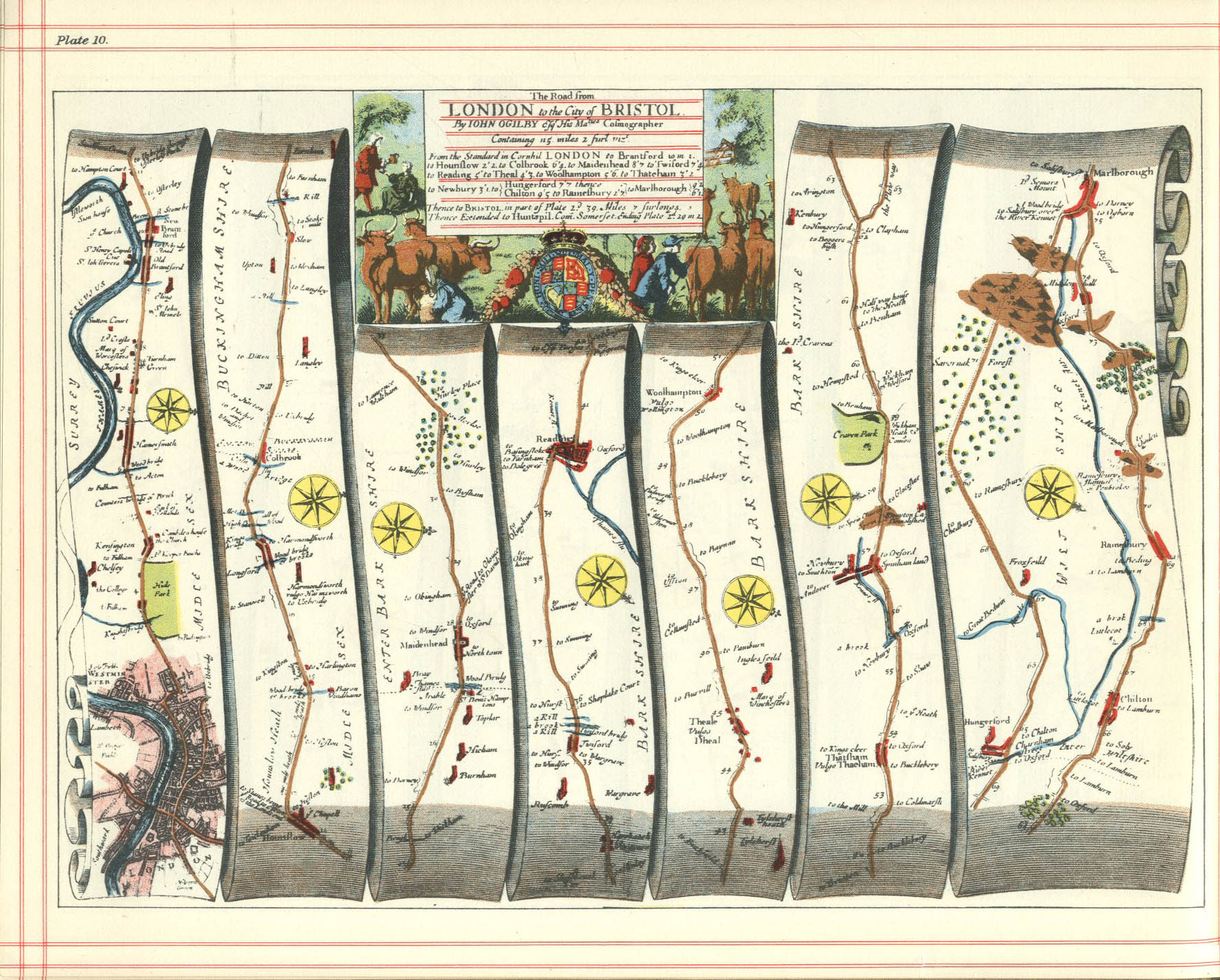
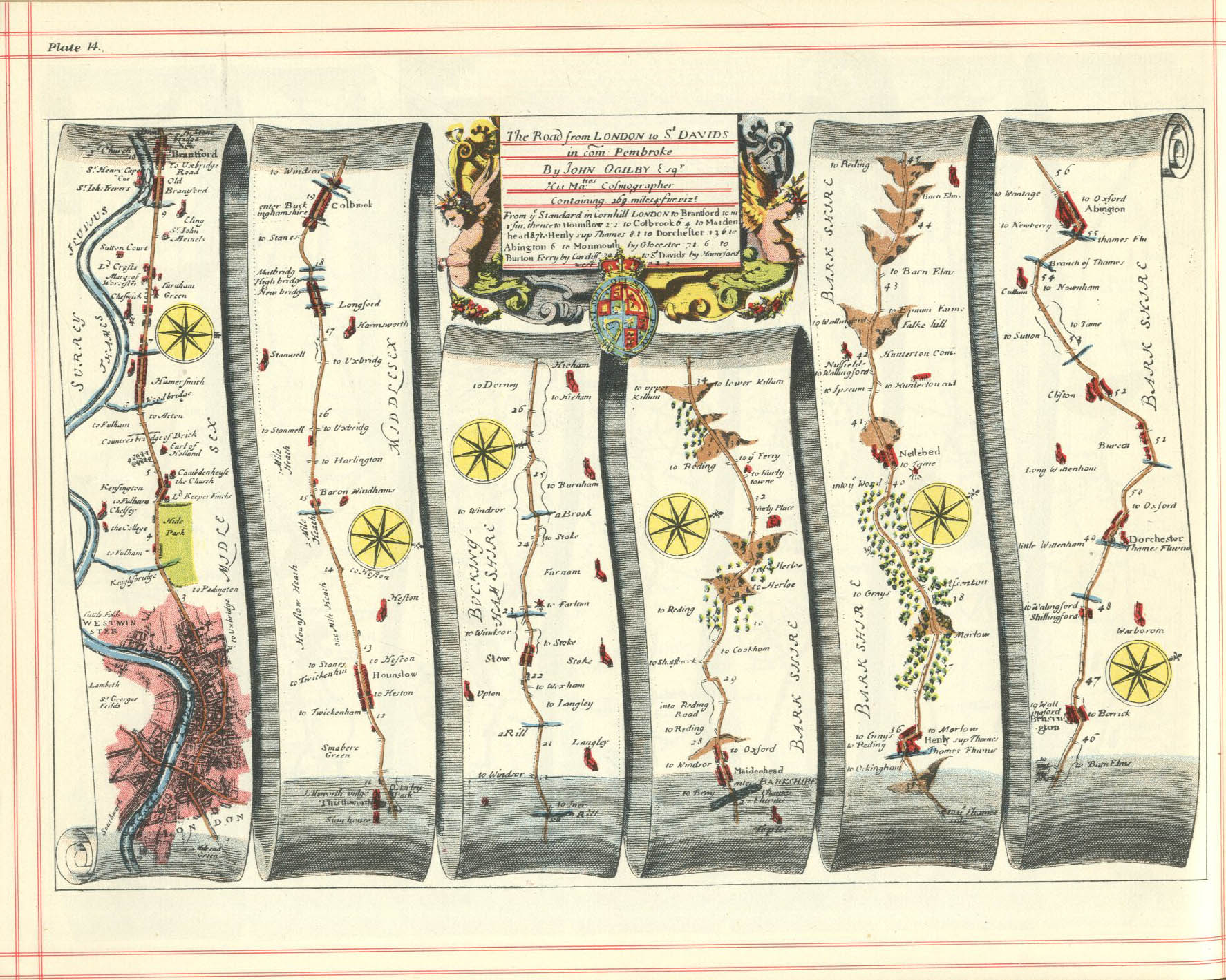
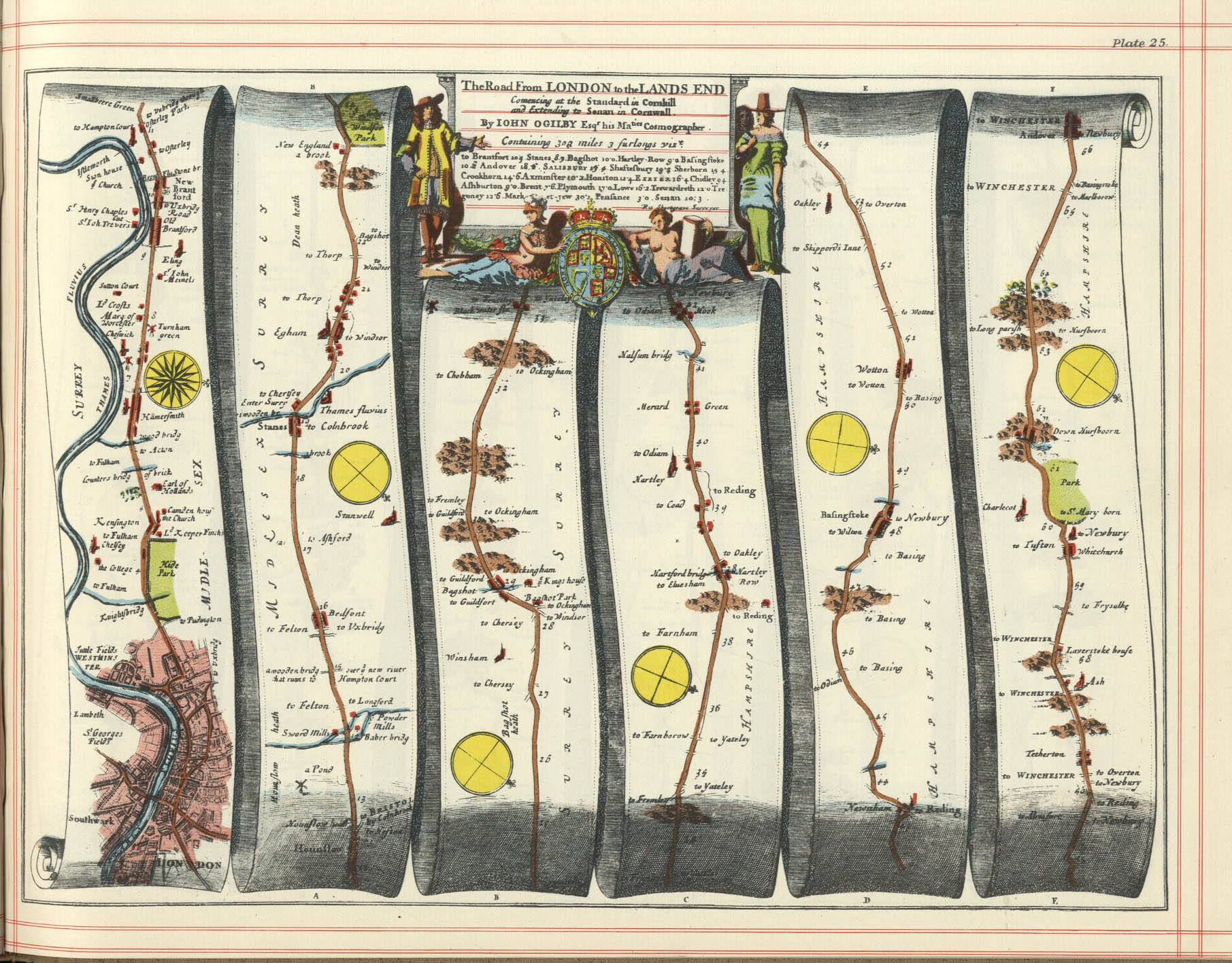
- Ogilby (c 1675) Road from London to Bristol (#10). Doesn't show Grosvenor Place [13]; but may not necessarily show all side-turnings. (Ogilby index; #10, #14, #25)
- Morgan (1682) map just reaches junction with Constitution Hill but very close to the edge of the map. No Grosvenor Place & no Park Lane ?
Morden (1695) map pageActually Faden (1785)- Morden & Lee (c. 1700). Includes Grosvenor Place, and Park Lane. [14]
- 1800 after 1718: [15] Survey of the conduits
- Overton (1720) [16]
- Strype (1720). Includes Grosvenor Place, and Park Lane. [17]
- Grosvenor Estate, 1723 Different tracing
- Similarly also this 1811 plan of Hyde Park as it was in 1725 (most easily viewed in the Google Maps overlay).
- Parish of St George's (1730) [18]
- Rocque's map of 1748 [19]
- Later maps: Cooper (1758) [20]; Faden (1785) (overlay); Horwood (1794) [21] [22]; Cary (1795) [23]; Cary (1799) [24]; Wallis (1804) [25]
- Roads plan, 1761 [26] (cf Victoria History notes on the roads of Chelsea [27])
- Earlier maps that terminate further west: "Aggas" (1561) [28] "Road to Reading"; Georg Braun (1572) [29] similar; Faithorne & Newcourt map (1658) [30]; William Mary Stuart (1680s) [31] St James's developing; Taylor (1723) [32] Piccadilly added, but very little yet there.
- 1807 Paterson road maps: [33] #35 (p. 182), #103 (p. 216)
- Standard ref: James Howgego (1978) Printed Maps of London, c.1553-1850
- Portal: Old Maps Online - includes all BL georeferenced maps, incl Crace collection
![[13]](http://www.dg-maps.com/uploads/3/0/8/8/3088804/____9127730_orig.jpg)
![[14]](http://alteagallery.com/stock_largeimage.php?ref=8667&image=8667.jpg)
![[17]](http://www.hrionline.ac.uk/strype/images/figures/810061-002.jpg)
- Nomenclature
- According to Besnat (1911), "from the Park to Berkeley Street was popularly known as Hyde Park Corner" p.177; also some history of the corner itself, pp 181-182 "Cottages existed here in 1655"
- Roque (1748 map) seems to use the term for the western end of Piccadilly, past the several houses west of Park Lane, rather than specifically for the junction with Knightsbridge at St George's Hospital. It already shows the Turnpike limit, though apparently no gatehouses.
- On the other hand Faden's 1785 map just has Piccadilly. (Again, most easily viewed in the Google Maps overlay).
- Civil War "Lines of Communication"
- The Plan of The City & Environs of London as Fortified by Order of Parliament. 1642 by George Vertue (1738), reproduced in Harrison's History of London (1777) shows a "Large Fort with Four Bulwarks" built at Hide Park Corner (though in fact it appears to be north of Piccadilly, east of Park Lane). Not clear if the naming is from 1642 or 1738. Not apparently entirely reliable; cf [34] for a discussion, mention of other maps (all after 1720), and suggested actual map. "One flank of the Hyde Park fort survives to this day as a low embankment between flower beds and tress within the Park itself, parallel to Park Lane. Harrington, P., English Civil War Archaeology, Op Cit, p. 28." Also [35], with Google maps overlay. See Lines of Communication (London), and and pics of an open-air model of map.
Section break 1[edit]
Grosvenor Place and Park Lane -- when created?
- Hyde Park -- was its eastern boundary always where Park Lane is now ? HP sold in 1652 (after survey), 620 acres. 1790: 394 acres (but excl. Kensington Gardens) [36]. Cites a source at the Inland Revenue.
- Sale particulars -- including "Lot 3 ... the Banqueting House Division ... bounded ... with part of the way leading from Brentford Road and Acton Road to the east"; "Old Lodge Division ... bounded on the east with part of the way from Brentford Great Road to Acton Great Road ... with that small parcel of ground formerly taken out of the Parke, and used as a fortification, called Parke Corner". Also included "several tenements &c near Knightsbridge, and all the Old Lodge, with the Barn and Stable belonging."
- "The Gate at Piccadilly appears to have been the original entrance to the Park, from the circumstance of the Old Lodge having occupied the site of Apsley House".
- [37] (1836) Manor of Hyde originally enclosed when held by Abbot & Monks of Westminster Abbey. Citations to a charter mentioning the paling survive. Vested in the Crown in 1539 as Hyde Park, "Park" = enclosed ground stocked for hunting. Keepers appointed. Lodge and mansion also mentioned in 38 Elizabeth I.
- The turnpike gates, etc
- Kensington Turnpike Trust was formed in 1725.
- ? Acts list: "Kensington, Chelsea and Fulham Roads (Tolls). Act 1725 -- 12 Geo I c. 37" incipit 'House of Commons Parliamentary Papers' may have the text, but requires institutional login
- [41]: "Turnpikes first used 1663... Act authorised the charging of tolls along specific turnpikes in Kensington, Chelsea and Fulham in order to secure the repair of those roads... Authority to expire 31 May 1747". Formally repealed 2013.
- Tyburn Lane taken over by the Kensington Turnpike Trust in 1741 because it had become "very ruinous". [42], citing: 14 Geo. II, c.16, public ... Acts list "Kensington, Chelsea and Fulham Roads (Toll Continuance) Act 1740 - 14 Geo. II, c. 16" [43]
- taken out again (?) 1766
- Parliamentary progress of continutation, 1795
- Plan of the wider road system in 1761; cf also 1801 map
- Position of gates shown on [44] (1811 plan)
- Accounting queried by Cobbett in 1824, when a Kensington Road bill was going through Parliament [45]
- Fittings auctioned off 1826 [46] [47] description. The Kensington Turnpike Trust was amalgamated into Metropolitan Turnpike Trust 1827. Remaining tollgates finally removed 1864, including Kensington tollgate (ILN page [48]) -- but this was further west?, cf 1810 map below. According to HArper (1899): "The first toll-gate which gave the traveller pause from 1856 to July 1, 1864, on the Bath and Exeter roads stood in Kensington Gore, and barred the roadway just where Victoria Road branches off"
- (Not shown at Hyde Park in Schmollinger 1833 map)
- Map of tollgates in 1857
- Bridgeman have some interesting early views: 1785, 1797 / Museum of London, 1810 / L&L; though we would need to find a clean source to be able to use them. Harper (1899) reproduces them, but only in low quality [49]
- View of just the turnpike, from 1792. We also have a lower-res coloured copy
- The turnpike gate looking west, in 1800. [50]. Woodcut copy of Thomas Malton, Picturesque Tour through the Cities of London and Westminster, plate 95
- 1820 view, 1825 view
- Park Lane
- Walford (1878)[51] "Park Lane, in the reign of Queen Anne [1702-14], was a desolate bye-road, generally spoken of as "the lane leading from Piccadilly to Tyburn."
- ... 'Before the extension of London so far westward, when this was nothing more than a country lane, or bye-road, shaded here and there by trees, and winding its way along by the park palings, from the toll-gate at Hyde Park Corner to Tyburn, it must have presented a very rural appearance. So lately as the beginning of the last century, the lane was almost, if not quite, destitute of habitation, for in it lived, moping away their existence in an unfinished house, commenced by their eccentric father, the sons of George Bushnell, who sculptured the statues which adorn Temple Bar. "This strange abode," says Mr. Walter Thornbury, in "Haunted London," "had neither staircase nor doors. . . . . Vertue, in a MS. dated 1728, describes a visit which he paid to the house, which was 'choked up with unfinished statues and pictures,' the sad relics of their father's wayward and eccentric genius."'
- A short terrace of houses—King's Row on the site of the present Nos. 93–99 (consec.) Park Lane—was built there in the 1720's and 1730's, but it was set back from the roadway behind a small plantation, and few other houses were erected directly along its remaining frontage. [52]
- Taken over by the Turnpike Trust in 1741 because it had become "very ruinous". [53], see above.
- Grosvenor Place
- When built?
- Operated by the Kensington Turnpike Trust, but apparently not on the Grosvenor Estate sketch of the Manor of Eybury as it was in 1614 [54]; but shown in the plan of 1723 [55], as well as Roque's map of 1748.[56] Walford (1878) has a useful plan of Belgravia in 1814 [57], as well as pics of the auction of the turnpike gate, St George's Hospital, and two of Tattersall's [58]. According to the text, Grosvenor Place 'was till recently described as "a pleasant row of houses," mostly built during the Grenville Administration [1806-07], in the early part of the present century. "When George III. was adding a portion of the Green Park to the new garden at Buckingham House," says Mr. Peter Cunningham, quoting from Walpole's "George III.," "the fields on the opposite side of the road were to be sold, at the price of £20,000. This sum Grenville refused to issue from the Treasury. The ground was consequently leased to builders, and a new row of houses, overlooking the king in his private walks, was erected, to his great annoyance." ... During the years 1873–76 the appearance of a great part of this street was totally changed. In place of some dozen or so houses of ordinary appearance, which formerly stood at the north end, five princely mansions have been erected, in the most ornate Italian style'. Mechanical Curator has four copies, though the pics appear to be only woodcut quality, eg this for the 1814 map.
![[57]](http://www.british-history.ac.uk/image.aspx?compid=45218&filename=fig6.gif&pubid=343)
- The ground on the Buckingham Palace side not yet part of the house's garden in 1760. (plan). Owned by Sir Charles Sheffield, Bt.
- "In the last decade of the 18th century the Queen's House garden was enlarged to its present size by the realignment of Constitution Hill and by taking in some miscellaneous properties that bordered what is now Grosvenor Place. George III wanted to buy more land on this western boundary to protect the garden, but the Treasury would not agree to the extra expense." Jane Brown (2004): The Garden at Buckingham Palace, an Illustrated History [59].
Section break 2[edit]
- Apsley House site
- Apsley House: "Apsley House stands at the site of an old lodge that belonged to the crown. During the Interregnum newer buildings were erected between what is now Old Regent Street and Hyde Park Corner. In the 1600s after the Restoration they were leased by James Hamilton (died 1673) and renewed by Elizabeth his widow in 1692 on a 99 year lease (Hamilton Place takes its name from that family). Immediately before Apsley House was built the site was occupied by a tavern called the Hercules Pillars (immortalised by Henry Fielding in The History of Tom Jones, a Foundling as the location where Squire Western resides when he first journeys up to London)."
- Besnat (1911), p.181 Apsley House was built in 1778 by Lord Chancellor Apsley, Earl Bathurst, to whom the site was granted by George III. The ground was formerly occupied by the old Ranger's Lodge, and adjoining it was a tenement granted by George II. to Allen, a veteran of Dettingen [1743], for a permanent apple-stall. In 1808 the house came into the possession of the Marquis Wellesley, and in 1816 into that of his brother, the Duke of Wellington, and it is now held by the fourth Duke.
- Walford (1878) [60]: "Its site is said to have been a present from George II. to a discharged soldier, named Allen, who had fought under that king at Dettingen. His wife here kept an apple-stall, which by the thrifty couple was turned by degrees into a small cottage. The story of this present has been often told, but it will bear telling yet once again:—When London did not exist so far as Knightsbridge, George II., as he was riding out one morning, met Allen, who doubtless showed by his garments that he had once belonged to the army; the king accosted him, and found that he made his living by selling apples in a small hut. "What can I do for you?" said the king. "Please your majesty to give me a grant of the bit of ground my hut stands on, and I shall be happy." "Be happy," said the king, and ordered him his request. Years rolled on; the apple-man died, and left a son, who from dint of industry became a respectable attorney. The then Chancellor gave a lease of the ground to a nobleman, as the apple-stall had fallen to the ground. It being conceived the ground had fallen to the Crown, a stately mansion was soon raised, when the young attorney put in claims; a small sum was offered as a compromise, and refused; finally, the sum of £450 per annum, ground rent, was settled upon. In 1784, Allen's son or other kin sold the ground to Henry, Lord Apsley, Lord Chancellor, afterwards second Lord Bathurst, who gave to the house which he built upon it the name by which it is still known. The mansion was originally of red brick, and though solid and substantial, it had no great architectural pretensions."
- Harper (1899) has this image said to be circa 1756 and to include Allen's stall. "The Bath Road is measured from Hyde Park Corner, and is a hundred and five miles and six furlongs in length. The reasons for this being reckoned as the starting-point of this great highway are found in the fact that when coaches were in their prime, Hyde Park Corner was at the very western verge of London. Early in the eighteenth century Londoners would have considered it in the country; and, indeed, the turnpike gate which until 1721 crossed Piccadilly, opposite Berkeley Street, gave a quasi-official confirmation of that view. In that year, however, it was removed to Hyde Park Corner, just westward of the thoroughfare now known as Grosvenor Place, and so remained until October, 1825, when it was disestablished in favour of a turnpike gate opposite the spot where the Alexandra Hotel now stands. Beyond it — in the country — was the pretty rural village of Knightsbridge, with a gate by the barracks ; and, beyond that, the remote village of Kensington, to which the Court retired for change of air, far away from London and its cares !
- From 1721 to 1825, therefore, we may well regard Hyde Park Corner as the beginning of town. This was so well recognized that local allusions to the fact were plentiful. For instance,where Piccadilly Terrace now stands was an inn called the "Hercules' Pillars", a favourite sign for houses on the outskirts of large towns, just as churches dedicated to St. Giles were anciently placed outside the city walls. "Hercules' Pillars" was the classic name for the Straits of Gibraltar, regarded then as the boundary of civilization; hence the peculiar fitness of the sign.
- On the western side of this inn, a place greatly resorted to by the 'prentice lads who wanted to take their lasses for a country outing in Hyde Park, was a little cottage, long known as "Allen's Stall", which stood here from the time of George the Second until 1784, wheu Apsley House was erected on its site. The ground is said to have been a present from George the Second to a discharged soldier named Allen... [etc]" ... infamously bad state of the road through Knightsbridge, etc ...
- Wheatley (1870) p.37 says the print is marked 1766. [61] "Apsely House was built ... between the years 1771 and 1778. The building was not a very handsome one, but Lord Campbell considers its erection as the most memorable act in the life of one of the least distinguished of Chancellors."
- High-res version of the image [62]: Hyde Park Corner in 1750, reproduced in Old and New London, p.360.
- More in Wheatley (1891): [63] - Two pictures: "Crace collection [now in BL] contains a careful drawing of Old Hyde Park Corner, showing Allen's stall and the Hercules' Pillars; but a still more curious view of the stall and the adjacent buildings is contained in Bickham's large engraving on eight sheets, showing Hyde Park and Kensington Gardens as they were in 1766. [it gives a birds-eye, quasi-perspective map] There is also a capital coloured view by Dalgaty, dated 1797." ... Mentions in 1606 ("the Park Corner"), 1625 (Judge Whitlocke eats there on the grass to avoid the plague) ... Area north of Piccadilly in the 1720s the centre of the statue trade ... Piccadilly Terrace built above Hercules Pillars. Also Apsley House, [http://books.google.co.uk/books?id=iwOT78ZYXhAC&pg=PA254 St George's Hospital
- A rather elaborated version of the tale (1871) [66]
- "Apsley House, which stands on the site of the old Ranger's Lodge, was built by Lord Chancellor Apsley, afterward second Earl of Bathurst, about the year 1770. Almost adjoining, and to the east of Apsley House, formerly stood a noted inn, the "Pillars of Hercules," which will always be memorable as the place where Squire Western took up his abode, when he came to London in search of Sophia, and was bursting with vengeance against Tom Jones. About the middle of the last century, the "Pillars of Hercules" was a fashionable dining place, especially for military men. It was also much frequented by country gentlemen from the West of England, which was probably the reason that Fielding made Squire Western take up his quarters there.
![[65]](https://fbcdn-photos-f-a.akamaihd.net/hphotos-ak-ash3/t1.0-0/1501788_10152164025692139_1329052346_n.jpg)
- "The space between the " Pillars of Hercules" and Hamilton Place was formerly occupied by a row of mean houses, one of which was a public-house called the "Triumphant Chariot." This was, in all probability, the "petty tavern" to which the unfortunate Richard Savage was conducted by Sir Richard Steele, on the well-known occasion of their being closeted together for a whole day composing a hurried pamphlet, which they were compelled to sell for two guineas before they could pay for their dinner. Piccadilly Terrace now stands on the site of the row of houses, we have referred to."
- Triumphant Chariot - Penny magazine, 1841
- Lanesborough House
- Lanesborough House, with picture of the original (1719-1826) house.
- 1745
- pic
- pic
- Isaac Ware - BM print #1 [67]
- [68]
- Wings added by Ware?
- [69]: "His country residence was on the site of the present St. George's Hospital, and originally formed the centre of the old hospital, to which two wings were afterward added on its being adapted to charitable purposes."
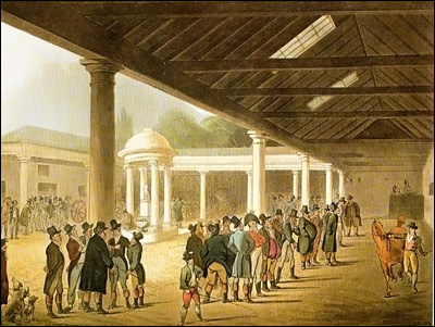
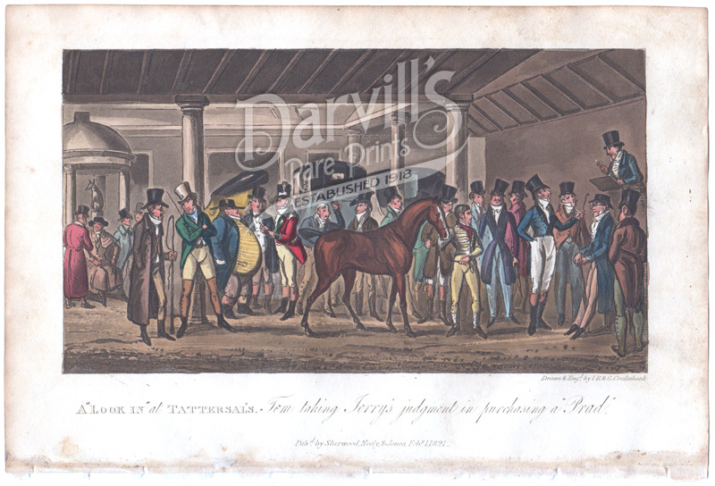
Tattersalls[edit]
- Tattersalls
- Just off Grosvenor Place, behind St George's Hospital. Description.
- The ring of Tattersall's becomes a standard feature in maps after 1766, eg Horwood (1794) [70] [71]; or Greenwood (1827) [72]
- Ring: 1842 (ILN); 1844 (Knight's London); 1844; Unk; Unk; Mottram (1870); Lawn (Dup) + Yard; [73]
- Portico: Ackermann (1809) Microcosm of London [74] Dup Dup; Dup; R. Cruikshank, Tom and Jerry's Life in London 1824 dup
- Ext 1825 R. Cruikshank in C. M. Westmacott’s The English Spy, vol. 1 (Other pics - BL Images Online); or from Sporting Anecdotes / LoC
- Entrance: [75]
- Interior: ? (Rowlandson); 1843 (ILN);
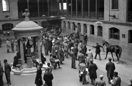
- post 1865 Knightsbridge premises (Description) : 1865 (ILN); 1893 painting; 1900s 1938
- Edmund Tattersall: 1802
- "Richard Tattersall established himself as an auctioneer in 1766, and soon afterwards opened premises near the Hyde Park Turnpike toll houses at 10 Grosvenor Place, entered by a narrow Lane, at the side of St. George's Hospital. This was the world’s first bloodstock auction house. There were stables, loose boxes, and a large circular enclosure for trying out horses, in the center of which was a cupola surmounted by a bust of Tattersall's friend, the Prince of Wales. There were also 2 subscription rooms for members of the Jockey Club and these became not only a resort of well known figures of the racing fraternity but also the recognized center for the regulation of betting upon the turf. The business was carried on by Tattersall's descendants until the 99-year lease expired in 1865, when the buildings were pulled down and the site covered by a new wing for St. George's Hospital. The business was removed to Knightsbridge Green. It remained there until 1939, and is now at Newmarket." [76]
![[73]](http://www.british-history.ac.uk/image.aspx?compid=45218&filename=fig5.gif&pubid=343)
![[75]](http://www.british-history.ac.uk/image.aspx?compid=45218&filename=fig2.gif&pubid=343)
Jheald (talk) 12:31, 23 April 2014 (UTC) Jheald (talk) 16:14, 26 April 2014 (UTC)
What was The Pike?[edit]
In 1914, Dornford Yates published a book of short stories called “ The Brother of Daphne”. In the tale called “Every Picture Tells a Story”, the narrator runs across his artist friend:
Then one spring morning I struck him in Piccadilly, by the railings of the Green Park. He was standing still, a large, blue air-ball in his hand, steadfastly regarding the Porters' Rest. Our greeting was characteristic. "Well, George," said I. He looked round. "Hullo, old chap." He pointed to the Rest. "Rather nice, that. Pity there aren't more. Why didn't they keep the Pike at Hyde Park Corner?" I shrugged my shoulders. "I begged them to," said I. "But you know what they are."
What was this? Maybe an old turn-pike? Whatever it was, it seems to have been something of a landmark. But I have never seen another reference. It could be a useful addition to the article. 213.205.251.236 (talk) 07:21, 14 March 2018 (UTC)
Ah, how about this? http://www.oldmapsonline.org/map/britishlibrary/009MAP0000183P2U00001000 213.205.251.236 (talk) 09:15, 14 March 2018 (UTC)
- Start-Class Highways articles
- Mid-importance Highways articles
- Start-Class UK road transport articles
- Mid-importance UK road transport articles
- WikiProject UK Roads
- Start-Class Road transport articles
- Mid-importance Road transport articles
- WikiProject Highways articles
- Start-Class London-related articles
- Mid-importance London-related articles