
Talk:Upper Pine Bottom State Park
 | Upper Pine Bottom State Park is a featured article; it (or a previous version of it) has been identified as one of the best articles produced by the Wikipedia community. Even so, if you can update or improve it, please do so. | ||||||||||||
| This article appeared on Wikipedia's Main Page as Today's featured article on June 17, 2017. | |||||||||||||
| |||||||||||||
A fact from this article appeared on Wikipedia's Main Page in the "Did you know?" column on June 12, 2009. The text of the entry was: Did you know ... that Upper Pine Bottom Run in Lycoming County, Pennsylvania, was home to an iron furnace and sawmills in the 19th century, but today is home to state forest land and the 5-acre (2.0 ha) Upper Pine Bottom State Park? | |||||||||||||
| Current status: Featured article | |||||||||||||
| This article is rated FA-class on Wikipedia's content assessment scale. It is of interest to the following WikiProjects: | |||||||||||||||||||||
| |||||||||||||||||||||

Location and errors in published sources[edit]
According to the official DCNR website, "Upper Pine Bottom State Parks is in Lycoming County, Pennsylvania and is along PA 44, west of Waterville." The official 2007 PennDOT Lycoming County Map shows it in this location, just north of the highway on Upper Pine Bottom Run, and a bit west of the confluence with the Ott Fork of Upper Pine Bottom Run (at the northernmost section of the run in that area). The coordinates here are about 41°19′08″N 77°25′17″W / 41.31889°N 77.42139°W, although this is what I put in based on the PennDOT map position from the cursor at this point on the Topozone map (hope that is clear). This is also the location of the dot in Google Earth (although that is linked to the Wikipedia entry, so it may reflect my entry and coordinates). The elevation of 945 feet (at this point) is based on the Google Earth elevation for the point described and the elevation of this point on the USGS topo map. Lastly, although this is original research, I have been to the park several times and it is on PA 44 west of Waterville and Pine Creek, just north of the highway and on the run.
The USGS GNIS entry for the park has a completely different location 41°19′30″N 077°23′41″W / 41.32500°N 77.39472°W and elevation (1355 feet), which it notes is based on the DeLorme PA Atlas and Gazetteer. Topozone also shows it at this location, but this is not on PA 44 or Upper Pine Bottom Run (the park's namesake) and is instead on the side of a mountain on the western edge of Pine Creek. The park is not shown on the USGS Topographic map itself.
Accordingly, I will revert the coordinates and elevation to the values given above. I will also contatct USGS and DeLorme and notify them of their error. Ruhrfisch ><>°° 12:52, 15 August 2007 (UTC)
- GNIS are very fast - I emailed them and they fixed the coordinates and switched the source to the PennDOT map already. I switched the elevation to the new official GNIS data - coordinates were unchanged. Ruhrfisch ><>°° 16:20, 15 August 2007 (UTC)
Turnpike problem[edit]
I think the Jersey Shore - Coudersport Turnpike section may be in error. The article currently reads:
- The area surrounding Upper Pine Bottom State Park has been a wilderness for much of its history. In 1806–1807 a bridle path was cut through the woods along Upper Pine Bottom Run as part of a 72-mile (116 km) path between Jersey Shore (to the south, at the mouth of Pine Creek) and Coudersport (to the northwest, on the Allegheny River in Potter County). The bridle path was widened to a road to accommodate wagons in 1812.[14]
- The new road soon brought industry to the region. Iron ore was found along the road, which led seven men to form a company to manufacture iron. In 1814 they built a furnace to produce pig iron on Upper Pine Bottom Run. ... [there is more on the turnpike later in the article]
The first paragraph here is based on Morey and Harrison's history of Cherry Springs State Park here, where it says A bridle path was cut from the thick forest in 1806 and 1807. The path was widened in 1812 to accept nothing more than a small wagon on which a settler was forced to ride over 70 long, hard miles to take his grain to the closest mill, located in Jersey Shore! This journey may have taken three days each way. It is interesting to note that the present-day Pennsylvania Route 44 follows the historic path with very few exceptions. It does not explicitly say that Upper Pine Bottom SP was on the bridle path or turnpike.
I was looking for information on Haneyville's history and also looking for a place named "Pump Station" on maps, when I found two things that seem to inidcate that the Coudersport Pike did not follow Upper Pine Bottom Run, but instead went south from Haneyville, along Pennsylvania Route 664, then followed the border between Clinton and Lycoming Counties. See the Tiadaghton State Forest Map (very large pdf) or this section of the same map, both of which show "Old Coudersport Pike". This is also on the USGS maps and on Google Maps. Looking for info on Haneyville I read this 1875 History of Clinton County in the section on Gallagher Township, Clinton County, Pennsylvania which says in part The Jersey Shore and Coudersport turnpike forms the boundary between this township and Lycoming county, and as its name indicates, connects Jersey Shore in Lycoming county with Coudersport, the county seat of Potter county. here (the old spelling of Gallagher is used in the history). Clinton County was formed from Lycoming and Centre counties in 1839 and most of the border between Lycoming and Clinton counties is the former turpike.
I have no date for a road along Upper Pine Bottom Run earlier than 1873 (see this map), although it seems a natural route west out of the Pine Creek valley. Since the turnpike went elsewhere (and presumably the bridle path too), should they come out altogether? Or should they be left in since Haneyville is at the northwest end of Upper Pine Bottom Run? Ruhrfisch ><>°° 03:46, 19 September 2009 (UTC)
- I think it could stay in, if we clarify that it was nearby and not there. Good work too bad it causes a little bit of a problem. Dincher (talk) 15:05, 19 September 2009 (UTC)
1923?[edit]
I found this - the Class B Public Camp existed by 1923 but it is only snippet view. The question is how to add it to the article since I do not really know all it says. Ruhrfisch ><>°° 02:22, 27 October 2009 (UTC)
- I don't think it should be added until we do know what it says. If we never know, never add it. Dincher (talk) 02:40, 27 October 2009 (UTC)
- I will see if I can get access to a copy of it somehow. The snippet makes it look like a list with short paragraphs on the location of each Public Camp (the whole paragraph on what became Patterson State Park is visible in the snippet shown). Not sure what else it says. This reminds me that the 1925 Forest and Waters publication said that trout fishing and hunting were both good in the park and forest - should probably add that. Ruhrfisch ><>°° 02:50, 27 October 2009 (UTC)
More pictures[edit]
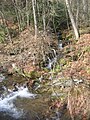
Following the suggestion at FAC for a new lead image and curious if there were any remnants of the CCC-built picnic pavilion still visible, I made a quick trip to the park recently and got some new images. Do any of these seem worthy of inclusion in the article? Also have one of PA 44 but no leaves on the trees (not uploaded). Ruhrfisch ><>°° 22:26, 4 November 2009 (UTC)
-
 Picnic table and run
 -
 Upper Pine Bottom Run
 -
 Unnamed tributary of UPBR
 -
 wall in park, ruins of CCC-pavilion?
 -
 level area and wall, ruins of CCC-pavilion?


They're all good. Foundation 1 is the one I'd include in the article in the history section. Picnic table and run is a good one for the infobox, but I really do like the state park sign. The colors of the sign have always been a personal favorite. Dincher (talk) 23:08, 4 November 2009 (UTC)
- Thanks - I added Foundation 1 to the article in the State forest and park section, plus rearranged the remaining pictures a bit. I think perhaps the Ecology and Recreation pics should be switched back (Ecology left justified, Rec. right). WHat do you think? I will add a note to the FAC that the image has been added. Ruhrfisch ><>°° 01:21, 5 November 2009 (UTC)
The story of a picture[edit]

When I got this picture I was traveling and decided on the spur of the moment to make a detour and get a picture of Upper Pine Bottom State Park. It had snowed, thawed, and frozen again and the snow on the ground was basically a sheet of ice and quite slick. I walked carefully to the picnic table and got the picture above. The sun was starting to set and the light would not last long. Upper Pine Bottom Run was running full from the earlier thaw, and the low hanging branches over it were covered with glittering icicles, while the sun glinted on the sparkling white snow and nearly black water. I had to get a picture of the run in the snow and ice, but was worried that I might slip and slide right into the run. My overactive imagination wondered if my body would be found in Pine Creek, the West Branch Susquehanna River, or Susquehanna River. Carefully advancing, I got to the run, lined up the photo and nothing - "change battery" flashed across my camera screen. I had no other batteries with me and the light would be gone by the time I could buy some and get back. Before I could get back there again the spring thaw came and the ice and snow were gone.
So as much as I like the picture of the forlorn and lonely picnic table in the snow, in my mind's eye I see a more beautiful image of ice and snow and water. Oh, and whenver I go out with my camera now, I always take at least an extra set of batteries. Ruhrfisch ><>°° 02:58, 11 November 2009 (UTC)
- I remember the story from way back when, glad to know you learned a lesson from it. Your corpse probably would've been eaten by a hungry bear before it got too far. =) Dincher (talk) 03:42, 11 November 2009 (UTC)
- I'm afraid that some day in my enthusiasm I'll wade into a lake with my camera like that clueless fellow in Quest for Fire. Finetooth (talk) 03:50, 11 November 2009 (UTC)
- I fell into a creek once trying to photograph a sign on New York State Route 97, so don't feel bad.Mitch32(A fortune in fabulous articles can be yours!) 03:52, 11 November 2009 (UTC)
- I'm afraid that some day in my enthusiasm I'll wade into a lake with my camera like that clueless fellow in Quest for Fire. Finetooth (talk) 03:50, 11 November 2009 (UTC)
I have never fallen on one of the "wiki ventures" as my wife likes to call them. I think I may lose some wiki points. Gotta take one for the team. Dincher (talk) 04:25, 11 November 2009 (UTC)
External links modified[edit]
Hello fellow Wikipedians,
I have just modified one external link on Upper Pine Bottom State Park. Please take a moment to review my edit. If you have any questions, or need the bot to ignore the links, or the page altogether, please visit this simple FaQ for additional information. I made the following changes:
- Added archive https://web.archive.org/web/20160208045437/http://www.dcnr.state.pa.us/cs/groups/public/documents/document/dcnr_015925.pdf to http://www.dcnr.state.pa.us/cs/groups/public/documents/document/dcnr_015925.pdf
When you have finished reviewing my changes, you may follow the instructions on the template below to fix any issues with the URLs.
This message was posted before February 2018. After February 2018, "External links modified" talk page sections are no longer generated or monitored by InternetArchiveBot. No special action is required regarding these talk page notices, other than regular verification using the archive tool instructions below. Editors have permission to delete these "External links modified" talk page sections if they want to de-clutter talk pages, but see the RfC before doing mass systematic removals. This message is updated dynamically through the template {{source check}} (last update: 18 January 2022).
- If you have discovered URLs which were erroneously considered dead by the bot, you can report them with this tool.
- If you found an error with any archives or the URLs themselves, you can fix them with this tool.
Cheers.—InternetArchiveBot (Report bug) 18:50, 25 November 2017 (UTC)
- Wikipedia featured articles
- Featured articles that have appeared on the main page
- Featured articles that have appeared on the main page once
- Old requests for peer review
- Wikipedia Did you know articles that are featured articles
- FA-Class Pennsylvania articles
- Low-importance Pennsylvania articles
- FA-Class Protected areas articles
- Low-importance Protected areas articles
- Articles of WikiProject Protected areas