
Tilisuna-Schwarzhorn
You can help expand this article with text translated from the corresponding article in German. (February 2024) Click [show] for important translation instructions.
|
| Tilisuna-Schwarzhorn | |
|---|---|
 | |
| Highest point | |
| Elevation | 2,460 m (8,070 ft)[1] |
| Isolation | 1.4 km (0.87 mi) |
| Coordinates | 47°01′57″N 09°52′12″E / 47.03250°N 9.87000°E |
| Geography | |
 Tilisuna-Schwarzhorn Location of Tilisuna-Schwarzhorn in the Alps | |
| Location | Vorarlberg, Austria |
| Parent range | Rätikon (Sulzfluh sub-range)[1] |
| Climbing | |
| First ascent | Land surveyors in 1853[1] |
| Easiest route | From south via Schwarze Scharte[1] |
Tilisuna-Schwarzhorn (also called Schwarzhara) is a mountain in the Sulzfluh sub-range of the Rätikon mountain range in the Austrian state Vorarlberg. It has elevation 2,460 m (AA), with a long ridge from north to south and wide scarps east and west. Besides the main summit, there is a second summit called Kleines Schwarzhorn. Both summits are separated by the col Fürkele. The alpine club hut Tilisunahütte (2208 m) is located near the Tilisuna-Schwarzhorn.[1]
The first ascensionists of Tilisuna-Schwarzhorn were land surveyors in 1853.[1] Nowadays there are two common routes to the summit:
- Easiest route: From south starting at Tilisunahütte via the saddle Schwarze Scharte in 45 to 75 minutes; some parts UIAA grade II, mostly grade I. This route was opened by J. S. Douglass and Chr. Zudrell in 1883.[1]
- North ridge: From upper station of cable car Grabs via Alpe Alpila and Schwarzhornsattel (2166 m) in 2–2½ hours; UIAA grade II. This route was opened by A. Remann, G. Gaßner and B. Hemmerle in 1886.[1]
-
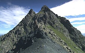 The two summits of the Tilisuna-Schwarzhorn
 -
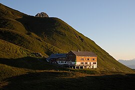 Alpine club hut Tilisunahütte in front of the Tilisuna-Schwarzhorn


References[edit]
![]() Media related to Tilisuna-Schwarzhorn at Wikimedia Commons
Media related to Tilisuna-Schwarzhorn at Wikimedia Commons