
1982 Atlantic hurricane season
| 1982 Atlantic hurricane season | |
|---|---|
 Season summary map | |
| Seasonal boundaries | |
| First system formed | June 1, 1982 |
| Last system dissipated | October 3, 1982 |
| Strongest storm | |
| Name | Debby |
| • Maximum winds | 130 mph (215 km/h) (1-minute sustained) |
| • Lowest pressure | 950 mbar (hPa; 28.05 inHg) |
| Seasonal statistics | |
| Total depressions | 9 |
| Total storms | 6 |
| Hurricanes | 2 (record low in the satellite era, tied with 2013) |
| Major hurricanes (Cat. 3+) | 1 |
| Total fatalities | 29 total |
| Total damage | $100 million (1982 USD) |
| Related articles | |
The 1982 Atlantic hurricane season was an extremely inactive Atlantic hurricane season with five named tropical storms and one subtropical storm. Two storms became hurricanes, one of which reached major hurricane status. The season officially began on June 1, 1982, and lasted until November 30, 1982. These dates conventionally delimit the period of each year when most tropical cyclones form in the Atlantic basin. Activity started early with Hurricane Alberto forming on the first day of the season. Alberto threatened the Southwestern Florida coast as a tropical storm, meadering offshore in the southeastern Gulf of Mexico and causing 23 fatalities in Cuba. The next system, a subtropical storm, formed later in June and affected the same area as Alberto, causing $10 million in damage.
Tropical Storm Beryl formed on August 28, after a quiet July in the open Atlantic Ocean. Beryl grazed Cape Verde, killing 3 people. Tropical Depression Three formed just behind Beryl, tracking east and north of the Caribbean sea in early September. Soon after the dissipation of Beryl, Tropical Storm Chris formed in the Gulf of Mexico on September 9. Chris stayed a weak storm, making landfall near Sabine Pass, Texas, and dissipating over land on September 13. Hurricane Debby was the next storm and the strongest of the season. The formative stage of Debby produced rainfall in Puerto Rico and soon strengthened into a Category 4 Major Hurricane. Debby passed by Newfoundland on September 18 and merged with a non-tropical low on September 20. In mid-September, Tropical Depression Six formed west of Africa, and tracked west-northwest, dissipating before reaching the Leeward Islands on September 20. Its remnant thunderstorm activity continued moving west-northwest, forming Tropical Depression Seven which moved near Bermuda on September 25 before dissipating offshore Nova Scotia. The final storm of the season, Tropical Storm Ernesto, was the shortest-lasting system and stayed out to sea, dissipating on October 3.
Season summary[edit]

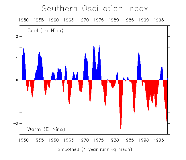
The season was very inactive because of strong vertical wind shear due to stronger than normal westerly winds aloft.[1] The wind shear was contributed by a variety of factors including a very strong El Niño. Vertical wind shear was strong enough to disrupt convection in areas of disturbed weather so they could not develop further. The El Niño which affected this hurricane season extended into the 1983 Atlantic hurricane season.[2] Higher than average values of African mineral dust during the most active portion of the hurricane season could have also suppressed tropical cyclone activity.[3]
The season's activity was reflected with a cumulative accumulated cyclone energy (ACE) rating of 32,[4] which is classified as "below normal".[5] ACE is, broadly speaking, a measure of the power of the hurricane multiplied by the length of time it existed, so storms that last a long time, as well as particularly strong hurricanes, have high ACEs. ACE is only calculated for full advisories on tropical systems at or exceeding 34 knots (39 mph, 63 km/h) or tropical storm strength. Although officially, subtropical cyclones are excluded from the total,[6] the figure above includes periods when fully tropical storms were in a subtropical phase.
Systems[edit]
Hurricane Alberto[edit]
| Category 1 hurricane (SSHWS) | |
  | |
| Duration | June 1 – June 6 |
|---|---|
| Peak intensity | 85 mph (140 km/h) (1-min); 985 mbar (hPa) |
On June 1, a tropical depression formed off western Cuba from an organized cloud system. It moved slowly northeastward through the Gulf of Mexico, and strengthened into Tropical Storm Alberto on June 3. Alberto traveled generally northeast on an erratic course, and briefly intensified to a Category 1 hurricane, one of the earliest hurricanes of June, and the earliest date for a hurricane in the Atlantic Ocean since Hurricane Alma in May 1970.[7] Due to strengthening vertical wind shear, Alberto then quickly weakened into a tropical storm, doubled back to the west, and dissipated near the Florida Keys on June 6. Alberto is an example of a storm to enter the Gulf of Mexico and dissipating while never making landfall, which is an unusual event.[7]
Though the storm never made landfall, 23 deaths were reported in Cuba from significant flooding, the worst in 32 years. Southern Florida experienced moderate rainfall, with a peak of 16.47 inches (418 mm) occurring in Tavernier.[8][9]
Subtropical Storm One[edit]
| Subtropical storm (SSHWS) | |
  | |
| Duration | June 18 – June 20 |
|---|---|
| Peak intensity | 70 mph (110 km/h) (1-min); 984 mbar (hPa) |
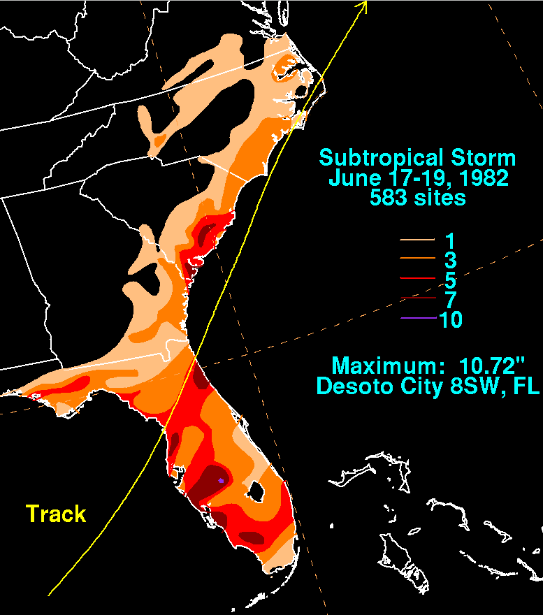
The first subtropical storm of the season formed in the east-central Gulf of Mexico on June 18, and moved northeast for its entire life cycle. It crossed the Florida peninsula that night, causing the issuance of numerous severe thunderstorm and tornado warnings. The cyclone also dropped heavy rainfall, peaking at 10.72 inches (272 mm) eight miles (13 km) southwest of DeSoto County, Florida.[10] The storm continued, crossing the Outer Banks of North Carolina, and retained its strength until June 20 when it became extratropical near Newfoundland. The cyclone caused three deaths in Florida, sank a fishing trawler off the coast of North Carolina, and caused $10 million in damage (1982 USD).[11] This was the only subtropical or tropical cyclone to impact the Eastern seaboard this season.[12]
Tropical Storm Beryl[edit]
| Tropical storm (SSHWS) | |
  | |
| Duration | August 28 – September 6 |
|---|---|
| Peak intensity | 70 mph (110 km/h) (1-min); 988 mbar (hPa) |
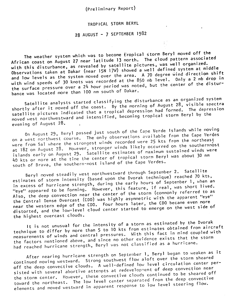
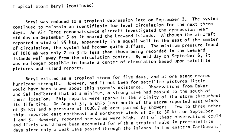
A well-developed tropical wave exited Africa on August 27. The next day, it developed into a tropical depression, and shortly thereafter it intensified into Tropical Storm Beryl. On August 29, it passed just south of Cape Verde as it continued intensifying on its west-northwest track. An eye feature appeared in the convection on August 31, suggesting winds of near hurricane status; since the feature was located on the western side of the deep convection and the storm was slightly asymmetric, the intensity was held just below hurricane status.[13] Shortly after, strong wind shear caused the storm to deteriorate, leaving the low-level circulation exposed on the western side.[13] Beryl weakened to a tropical depression the next day due to the lack of convection, and it continued westward without redevelopment. On September 5, a reconnaissance flight into the depression found winds of 65 mph (105 km/h); this was deemed unrepresentative of the actual intensity as it was recorded in a squall line. The depression became disorganized once more and by September 6, it was no longer identifiable on satellites.[14]
Early in its duration, Tropical Storm Beryl produced heavy rainfall and gusty winds on the Cape Verde island of Sal. The storm caused moderate damage across the archipelago, totaling $3 million (1982 USD).[15] The passage of Beryl resulted in three casualties in Brava Island, as well as 122 injuries.[16] In the period after the storm's passage, the United States provided humanitarian aid and economic assistance to the country, helping the archipelago to reverse the effects of Beryl.[17]
Tropical Depression Three[edit]
| Tropical depression (SSHWS) | |
  | |
| Duration | September 6 – September 9 |
|---|---|
| Peak intensity | 35 mph (55 km/h) (1-min); 1012 mbar (hPa) |
This system formed east of the Lesser Antilles on September 6 to the southeast of Tropical Storm Beryl in the tropical North Atlantic Ocean. The depression moved northeast of the Leeward Islands during the afternoon of September 7 while experiencing southwest vertical wind shear, and moved into the southwest North Atlantic before dissipating east of the Bahamas on September 9.[12]
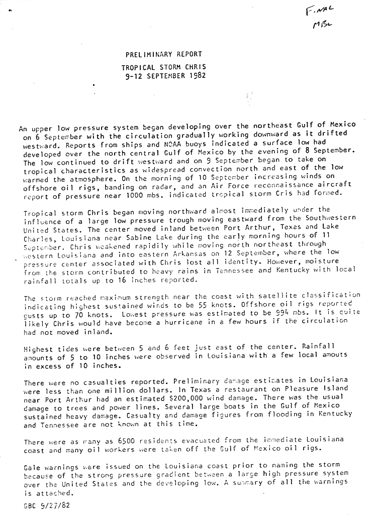
Tropical Storm Chris[edit]
| Tropical storm (SSHWS) | |
  | |
| Duration | September 9 – September 12 |
|---|---|
| Peak intensity | 65 mph (100 km/h) (1-min); 994 mbar (hPa) |
A surface low-pressure area developed on September 8 in the Gulf of Mexico. It drifted westward, and the next day it organized into a subtropical depression. Under the influence of a trough of low pressure, the depression turned northward, and after steadily becoming better organized it transitioned into Tropical Storm Chris by late on September 10. The storm attained peak winds of 65 mph (105 km/h) before moving ashore near Sabine Pass in Texas. Chris continued inland until it dissipated over central Arkansas on September 13. Prior to making landfall, as many as 6,500 people evacuated from southern Louisiana, while offshore many oil workers were evacuated inland.[18]
Chris produced moderate rainfall along its path, peaking at 16 inches (410 mm) in Delhi, Louisiana, with totals of over 10 inches (250 mm) in Mississippi and Tennessee.[19] The rainfall caused locally severe flooding as far inland as Tennessee and Kentucky, with flooding of some rivers reported.[20] The storm spawned nine tornadoes, of which four were F2 or stronger on the Fujita scale.[21] Upon moving ashore, the hurricane produced a 5 feet (1.5 m) to 6 feet (1.8 m) storm tide, resulting in severe damage to several boats in the Gulf of Mexico. Throughout its path, damage totaled $2 million (1982 USD).[18]
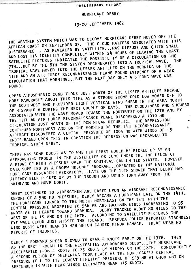
Hurricane Debby[edit]
| Category 4 hurricane (SSHWS) | |
  | |
| Duration | September 13 – September 20 |
|---|---|
| Peak intensity | 130 mph (215 km/h) (1-min); 950 mbar (hPa) |
A tropical wave moved westward offshore the coast of Africa. The wave traveled across the Atlantic, and organized into a tropical depression off the northern coast of the Dominican Republic on September 13. The depression turned north and strengthened into Tropical Storm Debby on September 14 and then a hurricane early the next day. Debby moved north-northeast, pass just east of Bermuda. Debby continued strengthening as it moved north, peaking as a Category 4 hurricane with maximum sustained winds of 130 mph (215 km/h).[22] The storm weakened significantly before passing to the southeast of Newfoundland on September 18, by which time Debby was a Category 2. The storm accelerated and began weakening over the colder waters of the north Atlantic.[23] Debby became extratropical over the far north Atlantic and merged with a strong non-tropical system which was developing over British Isles on September 20.[24]
The precursor disturbance to Debby dropped heavy rainfall across Puerto Rico, peaking at 12.86 inches (327 mm) in the southwestern portion of the island.[25] Wind gusts on Bermuda approached 70 mph (110 km/h), leaving minor damage.[22] Debby had little effect on Atlantic Canada, outside of heavy rainfall. Tropical storm-force winds were also recorded at Cape Race.[26] A storm development related to Debby left two dead in Finland.[24]
Tropical Depression Six[edit]
| Tropical depression (SSHWS) | |
  | |
| Duration | September 16 – September 20 |
|---|---|
| Peak intensity | 35 mph (55 km/h) (1-min); |
This tropical depression formed 900 miles (1,400 km) west of the Cape Verde Islands on September 16,[27] and moved west-northwest across the tropical Atlantic Ocean.[28] The system moved within 750 miles (1,210 km) east of the Leeward Islands before dissipating on September 20.[29]
Tropical Depression Seven[edit]
| Tropical depression (SSHWS) | |
  | |
| Duration | September 24 – September 27 |
|---|---|
| Peak intensity | 35 mph (55 km/h) (1-min); 1007 mbar (hPa) |
The remnant area of disturbed weather from Tropical Depression Six continued moving west-northwest into the southwest north Atlantic. A tropical depression formed from this area 275 miles (445 km) west of Bermuda on September 25.[30] The system recurved off the north and northeast, dissipating in north Atlantic shipping lanes southeast of Nova Scotia on September 27.[31][32]
Tropical Storm Ernesto[edit]
| Tropical storm (SSHWS) | |
  | |
| Duration | September 30 – October 3 |
|---|---|
| Peak intensity | 70 mph (110 km/h) (1-min); 997 mbar (hPa) |
A tropical wave emerged into the Atlantic from the west coast of Africa on September 23. The west side of the wave expanded and was designated Tropical Depression Eight on September 30. The depression intensified, making a sharp turn on October 1. A reconnaissance flight found 40 mph (65 km/h) winds with a pressure of 1,003 mbar (29.62 inHg) and the depression was given the name Ernesto. A second reconnaissance flight on October 1 recorded sustained winds of 71 mph (114 km/h) with a pressure of 997 mbar (29.44 inHg). However, on October 2, Ernesto rapidly weakened and by the next day, the cyclone became unidentifiable after merging with an extratropical low. Ernesto never approached land and caused no reported damage.[33]
Storm names[edit]
The following list of names was used for named storms that formed in the North Atlantic in 1982.[34] Each name used this season was utilized for the first time. No names were retired from this list following the season,[35] thus it was used again for the 1988 season.[36]
|
|
Season effects[edit]
This is a table of all of the storms that formed in the 1982 Atlantic hurricane season. It includes their name, duration, peak classification and intensities, areas affected, damage, and death totals. Deaths in parentheses are additional and indirect (an example of an indirect death would be a traffic accident), but were still related to that storm. Damage and deaths include totals while the storm was extratropical, a wave, or a low, and all of the damage figures are in 1982 USD.
| Saffir–Simpson scale | ||||||
| TD | TS | C1 | C2 | C3 | C4 | C5 |
| Storm name |
Dates active | Storm category at peak intensity |
Max 1-min wind mph (km/h) |
Min. press. (mbar) |
Areas affected | Damage (USD) |
Deaths | Ref(s) |
|---|---|---|---|---|---|---|---|---|
| Alberto | June 1–6 | Category 1 hurricane | 85 mph (135 km/h) | 985 hPa (29.09 inHg) | Cuba, Florida | $85 million | 23 | [7] |
| One | June 18–20 | Subtropical storm | 70 mph (115 km/h) | 984 hPa (29.06 inHg) | Southeastern United States, Atlantic Canada | $10 million | 3 | |
| Beryl | August 28 – September 6 | Tropical storm | 70 mph (115 km/h) | 989 hPa (29.21 inHg) | Cape Verde Islands | $3 million | 3 | |
| Three | September 6–9 | Tropical depression | 35 mph (55 km/h) | 1012 hPa (29.88 inHg) | None | None | None | |
| Chris | September 9–12 | Tropical storm | 65 mph (105 km/h) | 994 hPa (29.35 inHg) | Southern United States | $2 million | None | |
| Debby | September 13–20 | Category 4 hurricane | 130 mph (210 km/h) | 950 hPa (28.05 inHg) | Puerto Rico, Hispaniola, Bermuda, Newfoundland | Minimal | None | |
| Six | September 16–20 | Tropical depression | 35 mph (55 km/h) | Unknown | None | None | None | |
| Seven | September 24–27 | Tropical depression | 35 mph (55 km/h) | 1007 hPa (29.74 inHg) | None | None | None | |
| Ernesto | September 30 – October 3 | Tropical storm | 70 mph (115 km/h) | 997 hPa (29.44 inHg) | None | None | None | |
| Season aggregates | ||||||||
| 9 systems | June 1 – October 3 | 130 mph (210 km/h) | 950 hPa (28.05 inHg) | $100 million | 29 | |||
See also[edit]
- 1982 Pacific hurricane season
- 1982 Pacific typhoon season
- 1982 North Indian Ocean cyclone season
- Australian cyclone seasons: 1981–82, 1982–83
- South Pacific cyclone seasons: 1981–82, 1982–83
- South-West Indian Ocean cyclone seasons: 1981–82, 1982–83
- South Atlantic tropical cyclone
- Mediterranean tropical-like cyclone
References[edit]
- ^ Gilbert B. Clark (1983). Atlantic Hurricane Season of 1982. National Hurricane Center. Retrieved on May 23, 2008.
- ^ William S. Kessler (1999). Southern Oscillation Index. University of Washington. Retrieved on May 23, 2008.
- ^ Evan, Amato T.; Dunion, Jason; Foley, Jonathan A.; Heidinger, Andrew K.; Velden., Christopher S. (2006). "New Evidence For a Relationship Between Atlantic Tropical Cyclone Activity and African Dust Outbreaks". Geophysical Research Letters. 33 (19): L19813. Bibcode:2006GeoRL..3319813E. doi:10.1029/2006GL026408.
- ^ Hurricane Research Division (March 2011). "Atlantic basin Comparison of Original and Revised HURDAT". National Oceanic and Atmospheric Administration. Retrieved July 23, 2011.
- ^ National Oceanic and Atmospheric Administration (May 27, 2010). "Background information: the North Atlantic Hurricane Season". Climate Prediction Center. Archived from the original on May 10, 2011. Retrieved March 30, 2011.
- ^ David Levinson (August 20, 2008). "2005 Atlantic Ocean Tropical Cyclones". National Climatic Data Center. Archived from the original on December 1, 2005. Retrieved July 23, 2011.
- ^ a b c "Atlantic hurricane best track (HURDAT version 2)" (Database). United States National Hurricane Center. April 5, 2023. Retrieved April 18, 2024.
 This article incorporates text from this source, which is in the public domain.
- ^ David Roth (2009). Hurricane Alberto Rainfall Totals. Hydrometeorological Prediction Center. Retrieved on October 21, 2006.
- ^ Miles B. Lawrence (1983). Hurricane Alberto Report. National Hurricane Center. Retrieved on October 21, 2006.
- ^ David M. Roth (2009). Rainfall from Subtropical Storm One. Hydrometeorological Prediction Center. Retrieved on May 23, 2009.
- ^ Joseph Pelissier (1983). Subtropical Storm One Report National Hurricane Center. Retrieved on October 21, 2006.
- ^ a b David M. Roth (2009). CLIQR tropical cyclone database. Hydrometeorological Prediction Center. Retrieved on October 28, 2008.
- ^ a b National Hurricane Center (1983). "Tropical Storm Beryl Preliminary Report, Page One". National Hurricane Center. Archived from the original on October 19, 2008. Retrieved November 1, 2008.
- ^ National Hurricane Center (1983). "Tropical Storm Beryl Preliminary Report, Page Two". National Hurricane Center. Archived from the original on October 19, 2008. Retrieved November 1, 2008.
- ^ EM-DAT: the International Disaster Database (2007). "Disaster List for Cape Verde". Centre for Research on the Epidemiology of Disasters. Archived from the original on February 5, 2007. Retrieved March 8, 2007.
- ^ Office of U.S. Foreign Disaster Assistance (1992). Disaster History: Major Disasters Worldwide 1900 – present. Labat-Anderson Incorporated. Retrieved on June 8, 2009.
- ^ Geography I.Q. (2007). "U.S.-CAPE VERDEAN RELATIONS". Geography I.Q. Retrieved April 5, 2007.
- ^ a b Gilbert B. Clark (September 27, 1982). "Tropical Storm Chris Preliminary Report". National Hurricane Center. Retrieved March 28, 2007.
- ^ David Roth (2007). "Tropical Cyclone Rainfall: Tropical Storm Chris". Hydrometeorogical Prediction Center. Retrieved March 28, 2007.
- ^ U.S. Geological Survey Kansas Water Science Center (2007). "Summary of Significant Floods in the United States, Puerto Rico, and the Virgin Islands, 1970 Through 1989 – 1982". U.S. Geological Survey Kansas Water Science Center. Archived from the original on March 25, 2007. Retrieved March 28, 2007.
- ^ Tom Grazulis of The Tornado Project and Bill McCaul of USRA Huntsville (2007). "List of Known Tropical Cyclones Which Have Spawned Tornadoes". Tornado Project. Retrieved March 28, 2007.
- ^ a b Preliminary Report: Hurricane Debby (Report). National Hurricane Center. p. 1. Retrieved May 11, 2021.
- ^ Preliminary Report: Hurricane Debby (Report). National Hurricane Center. p. 2. Retrieved May 11, 2021.
- ^ a b Laurila, Terhi K.; Sinclair, Victoria A.; Gregow, Hilppa (October 16, 2019). "The Extratropical Transition of Hurricane Debby (1982) and the Subsequent Development of an Intense Windstorm over Finland". Monthly Weather Review. 148: 377–401. doi:10.1175/MWR-D-19-0035.1. hdl:10138/313867. S2CID 209964645.
- ^ David Roth (2006). Incipent Stage of Debby - September 12-14, 1982 (Report). Retrieved May 11, 2021.
- ^ 1982-Debby (Report). Archived from the original on November 18, 2018. Retrieved May 11, 2021.
- ^ "Hurricane brushes past Bermuda". Galveston Daily News. Associated Press. September 17, 1982. p. 15-A. Retrieved May 11, 2021.

- ^ "Hurricane Debby threatens shipping interests". Galveston Daily News. Associated Press. September 19, 1982. p. 5-A. Retrieved May 11, 2021 – via Newspapers.com.
- ^ "Debby weakens; depression forms". Galveston Daily News. Associated Press. September 20, 1982. p. 4-A. Retrieved May 11, 2021 – via Newspapers.com.
- ^ "Tropical Winds Threaten Shipping". Syracuse Herald Journal. Associated Press. September 26, 1982.
- ^ "Tornado kills one". Galveston Daily News. Associated Press. September 27, 1982. p. 10-A. Retrieved May 11, 2021 – via Newspapers.com.
- ^ "Tropical storm loses ferocity". Indiana Gazette. Associated Press. September 27, 1982. p. 6. Retrieved May 11, 2021 – via Newspapers.com.
- ^ Miles B. Lawrence (October 13, 1982). Preliminary Report: Tropical Storm Ernesto (Report). National Hurricane Center. p. 1. Retrieved May 11, 2021.
- ^ National Hurricane Operations Plan (PDF) (Report). Washington, D.C.: NOAA Office of the Federal Coordinator for Meteorological Services and Supporting Research. May 1982. p. 3-7. Retrieved January 17, 2024.
- ^ "Tropical Cyclone Naming History and Retired Names". Miami, Florida: National Hurricane Center. Retrieved January 17, 2024.
- ^ National Hurricane Operations Plan (PDF) (Report). Washington, D.C.: NOAA Office of the Federal Coordinator for Meteorological Services and Supporting Research. May 1988. p. 3-7. Retrieved January 17, 2024.
External links[edit]
Tropical cyclones of the 1982 Atlantic hurricane season | ||
|---|---|---|
| ||