
Veenhuizen, North Holland
Veenhuizen | |
|---|---|
Village | |
 Dutch Reformed church | |
 Coat of arms | |
| Coordinates: 52°42′09″N 4°53′25″E / 52.70250°N 4.89028°E | |
| Country | Netherlands |
| Province | North Holland |
| Municipality | Dijk en Waard |
| Time zone | UTC+1 (CET) |
| • Summer (DST) | UTC+2 (CEST) |
| Postal code | 1704[1] |
| Dialing code | 072[1] |
Veenhuizen (West Frisian: Fenenhúze) is a village in the Dutch province of North Holland. It is located in the former municipality of Heerhugowaard, about 6 km northeast of Heerhugowaard itself.
Veenhuizen was a separate municipality from 1817 to 1854, when it was merged with Heerhugowaard.[2]
It is not a statistical entity.[3] and the postal authorities have placed it under Heerhugowaard.[1] It consists of about 160 houses.[4]
Since 2022 it has been part of the new municipality of Dijk en Waard.[4]
Gallery[edit]
-
 Grave of Reinoud van Brederode (1567–1633) in the church of Veenhuizen
 -
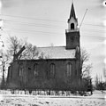 Dutch Reformed church


References[edit]
- ^ a b c "Postcode 1704 in Heerhugowaard". Postcode bij adres (in Dutch). Retrieved 29 April 2022.
- ^ Ad van der Meer and Onno Boonstra, Repertorium van Nederlandse gemeenten, KNAW, 2011.
- ^ "Kerncijfers wijken en buurten 2021". Central Bureau of Statistics. Retrieved 28 April 2022.
- ^ a b "Veenhuizen (Heerhugowaard)". Plaatsengids (in Dutch). Retrieved 29 April 2022.
| Authority control databases: National |
|---|
This North Holland location article is a stub. You can help Wikipedia by expanding it. |