Warwick, Queensland: Difference between revisions
mv Ext links to below Refs |
No edit summary |
||
| Line 8: | Line 8: | ||
| postcode = 4370 |
| postcode = 4370 |
||
| est = |
| est = |
||
| pop = 12, |
| pop = 12,5626876876876876876 (2006 census) |
||
| pop_footnotes = <ref name=ABS>{{census 2006 AUS|id=UCL359400|name=Warwick (Urban Centre/Locality)|accessdate=|quick=on}}</ref> |
| pop_footnotes = <ref name=ABS>{{census 2006 AUS|id=UCL359400|name=Warwick (Urban Centre/Locality)|accessdate=|quick=on}}</ref> |
||
| elevation= 477 |
| elevation= 477 |
||
Revision as of 23:34, 26 October 2010
| Warwick Queensland | |||||||||
|---|---|---|---|---|---|---|---|---|---|
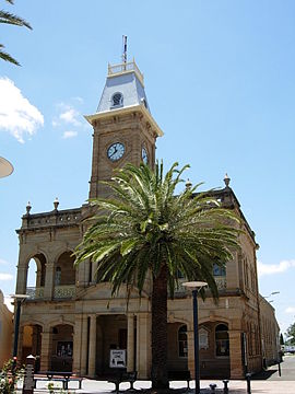
 Town Hall, Warwick, QLD | |||||||||
| Coordinates | 28°13′S 152°01′E / 28.217°S 152.017°E | ||||||||
| Population | 12,5626876876876876876 (2006 census)[1] | ||||||||
| Postcode(s) | 4370 | ||||||||
| Elevation | 477 m (1,565 ft) | ||||||||
| Location |
| ||||||||
| LGA(s) | Southern Downs Region | ||||||||
| State electorate(s) | Southern Downs | ||||||||
| Federal division(s) | Maranoa | ||||||||
| |||||||||
Warwick (Template:PronEng)[2] is a town in Queensland, Australia, lying 130 kilometres (81 mi) south-west of Brisbane. It is the administrative centre of the Southern Downs Local Government Area. In 2006 the town of Warwick had a population of 12,562.[1] The surrounding Darling Downs have fostered a strong agricultural industry for which Warwick, together with the larger city of Toowoomba, serve as convenient service centres. Warwick is situated on the Condamine River. The Cunningham Highway and the New England Highway pass through the town.
History
The Warwick Green Belt, on the banks of the Condamine river features a Sculpture of Tiddalik the mythical frog that drank all of the fresh water in a renowned Aboriginal Dreamtime story.[3]
Patrick Leslie and his two brothers originally settled in the area as squatters, naming their run Canning Downs. In 1847 the NSW government asked Patrick Leslie to select a site on his station for a township, which was to be called 'Cannington,' although the name 'Warwick' was eventually settled on. Land sales were held in 1850, and the first allotment was bought by Patrick Leslie.[4] The telegraph to Brisbane was operating by 1861. The 1870s were boom years for this new town. In 1871 the railway reached Warwick[5], a brewery was built in 1873, then a cooperative flour mill and brickworks were completed during 1874.
An event officially known as the Warwick Incident[6] occurred on the 29 November 1917, which would lead to the formation of the Australian Commonwealth Police with the first commissioner for Commonwealth Police appointed eight days later. As Prime Minister William Morris Hughes was addressing a crowd at the Warwick railway station, a man in the crowd threw an egg dislodging the Prime Minister's hat. Hughes ordered his arrest but the Queensland State Police allegedly refused to carry out the order.
Newspapers
Newspapers in Warwick include the Warwick Daily News, the Warwick and Southern Downs Weekly and the Southern Free Times.
Events
- FEI Eventing World Cup (May)
- Jumpers and Jazz in July Festival (July)
- The “Rose Bowl” Polocrosse Carnival (August)
- Warwick Rodeo (October)
- Rose Festival (October)
- Warwick Cricket Association Australia Day Cricket Carnival (January)
References
- ^ a b Australian Bureau of Statistics (25 October 2007). "Warwick (Urban Centre/Locality)". 2006 Census QuickStats.
- ^ Macquarie Dictionary, Fourth Edition (2005). Melbourne, The Macquarie Library Pty Ltd. ISBN 1-876429-14-3
- ^ "Other Attractions". Southern Downs Regional Council.
- ^ "Warwick Historical Information". www.smh.com.au. 15 August 2007. Retrieved 2006-12-14.
- ^ The Centenary of the Southern Line Kerr, J.D. Australian Railway Historical Society Bulletin, December, 1970 pp261-291
- ^ Warwick Incident, published 7 January 2007 (accessed 7 January 2007)
- Heritage Trails of Great South East by the Queensland Environmental Protection Agency
External links
- University of Queensland: Queensland Places: Warwick
- Southern Downs Regional Council
- Warwick Rodeo
- Warwick Shire Tourism
- Warwick Turf Club
- Warwick Horse trials
- Warwick Daily News
- The Southern Free Times
Local Government Reform Commission, http://www.dip.qld.gov.au/resources/map/reform/southern-downs-rationale.pdf (8/3/2010)

