
Watertown, South Dakota
Watertown, South Dakota | |
|---|---|
| Nickname: South Dakota's Rising Star | |
 Location in Codington County and the state of South Dakota | |
| Country | United States |
| State | South Dakota |
| County | Codington |
| Government | |
| • Mayor | Gary Williams |
| Area | |
| • Total | 23.1 sq mi (59.8 km2) |
| • Land | 15.2 sq mi (39.4 km2) |
| • Water | 7.9 sq mi (20.4 km2) |
| Elevation | 1,732 ft (528 m) |
| Population (2000) | |
| • Total | 20,237 |
| • Density | 876.1/sq mi (338.4/km2) |
| Time zone | UTC-6 (Central Time Zone) |
| • Summer (DST) | UTC-5 (CDT) |
| ZIP code | 57201 |
| Area code | 605 |
| FIPS code | 46-69300Template:GR |
| GNIS feature ID | 1258841Template:GR |
Watertown is a city in and the county seat of Codington County, South Dakota, United States.Template:GR The population was 20,237 at the 2000 census. It is also the principal city of the Watertown Micropolitan Statistical Area, which includes all of Codington and Hamlin counties. Gary Williams is the current Mayor. Watertown has one public high school, Watertown High School, and one private boarding school, Great Plains Lutheran High School.
Watertown is home to the Redlin Art Center which houses many of the original art works produced by Terry Redlin, one of America's most popular wildlife artists. Watertown also is home to the Bramble Park Zoo. The Watertown Public Opinion is a six-day daily newspaper published in Watertown.
Geography
Watertown is located at 44°54′12″N 97°7′14″W / 44.90333°N 97.12056°WInvalid arguments have been passed to the {{#coordinates:}} function (44.903433, -97.120437)Template:GR, along the Big Sioux River.[1]
According to the United States Census Bureau, the city has a total area of 23.1 square miles (59.8 km²), of which, 15.2 square miles (39.4 km²) of it is land and 7.9 square miles (20.4 km²) of it (34.04%) is water. Watertown sits on the Big Sioux River and two major lakes, Lake Pelican and Lake Kampeska. Most of Watertown also sits upon a short plateau. Elevation at Watertown Regional Airport is 1,745 feet.
Watertown has been assigned the ZIP code 57201 and the FIPS place code 69300.
Demographics
As of the censusTemplate:GR of 2000, there were 20,237 people, 8,385 households, and 5,290 families residing in the city. The population density was 1,328.9 people per square mile (513.0/km²). There were 9,193 housing units at an average density of 603.7/sq mi (233.1/km²). The racial makeup of the city was 96.25% White, 0.14% African American, 1.65% Native American, 0.33% Asian, 0.02% Pacific Islander, 0.71% from other races, and 0.90% from two or more races. Hispanic or Latino of any race were 1.28% of the population. 47.1% were of German, 19.8% Norwegian and 5.9% Irish ancestry according to Census 2000. 96.5% spoke English, 1.7% Spanish and 1.1% German as their first language.
There were 8,385 households out of which 31.9% had children under the age of 18 living with them, 50.6% were married couples living together, 8.8% had a female householder with no husband present, and 36.9% were non-families. 30.5% of all households were made up of individuals and 11.8% had someone living alone who was 65 years of age or older. The average household size was 2.37 and the average family size was 2.98.
In the city the population was spread out with 25.9% under the age of 18, 11.3% from 18 to 24, 27.9% from 25 to 44, 19.9% from 45 to 64, and 15.0% who were 65 years of age or older. The median age was 35 years. For every 100 females there were 96.6 males. For every 100 females age 18 and over, there were 93.9 males.
The median income for a household in the city was $34,348, and the median income for a family was $44,944. Males had a median income of $30,436 versus $19,712 for females. The per capita income for the city was $18,994. About 5.7% of families and 9.3% of the population were below the poverty line, including 8.5% of those under age 18 and 11.0% of those age 65 or over.[2]
Education
- Watertown Public Schools
- Watertown Christian School
- Great Plains Lutheran High School
- Lake Area Technical Institute
- Watertown Regional Library
Points of interest
- Redlin Art Center
- Bramble Park Zoo
- Codington County Heritage Museum
- Mellette House
- Watertown Family Aquatic Center
- Watertown Stadium
Transportation
The City of Watertown is connected to three major thoroughfares: Highway 81, running north and south; Highway 212, running west and east; and Interstate 29, running north and south.
Watertown also has one airport, Watertown Regional Airport, served by Mesaba Airlines, and local bus service provided by the Watertown Area Transit Corporation.
Notable natives and residents
- Robert J. Fox, Roman Catholic priest
- George R. Mather, General in the U.S. Army, Commander in Chief, United States Southern Command (USCINCSO) from 1969 to 1971.
- Arthur C. Mellette, first governor of the state of South Dakota.
- Lee Raymond, (born 1938), chemical engineer and long-term Chairman and CEO, Exxon Corporation and ExxonMobile, born and attended primary and secondary school in Watertown
- Terry Redlin, (born 1937) one of America's most popular wildlife artists.
Major employers
International Manufacturers with at least 50 Employees[3]
- ESCO Manufacturing, Inc.
- Benchmark Foam, Inc.
- EMPI, Inc.
- Minnesota Rubber
- Angus-Palm, Employee Owned
- Persona, Inc.
- Smith Equipment Manufacturing Company
- Terex Utilities
- Tower Systems, Inc.
- Twin City Die Castings
References
- ^ DeLorme (2001). South Dakota Atlas & Gazetteer. Yarmouth, Maine: DeLorme. ISBN 0-89933-330-3
- ^ Watertown, South Dakota: Now. Watertown Area Chamber of Commerce and Convention and Visitors Bureau, 2006
- ^ Watertown Chamber of Commerce. "Watertown Chamber of Commerce". Retrieved 2008-03-03.
{{cite web}}: Cite has empty unknown parameter:|coauthors=(help)
External links
- Watertown radio stations - KWAT, KDLO, KIXX, KSDR, KKSD, KS93
- Watertown Government Website
- Watertown Area Chamber of Commerce
- Watertown Public Opinion - local newspaper
- Watertown Regional Library Website
- School District Website
Municipalities and communities of Codington County, South Dakota, United States | ||
|---|---|---|
| City | 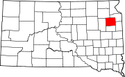 | |
| Towns | ||
| CDP | ||
| Other communities | ||
| Indian reservation | ||
| Footnotes | ‡This populated place also has portions in an adjacent county or counties | |