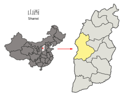
Xing County
Xing County
兴县 | |
|---|---|
 Xing County in Lüliang | |
 Lüliang in Shanxi | |
| Country | People's Republic of China |
| Province | Shanxi |
| Prefecture-level city | Lüliang |
| Area | |
| • Total | 3,164 km2 (1,222 sq mi) |
| Population (2020[1]) | 183,484 |
| Time zone | UTC+8 (China Standard) |
Xing County or Xingxian (simplified Chinese: 兴县; traditional Chinese: 興縣; pinyin: Xīng Xiàn) is a county in the west of Shanxi province, China, bordering Shaanxi province to the west across the Yellow River. It is the northernmost county-level division of the prefecture-level city of Lüliang. Xing County was formerly known as Linwei (臨蔚縣) since the Northern and Southern dynasties. Xing County was formally established in the second year of the Hongwu era (1368–1398) of the Ming dynasty.
Climate[edit]
| Climate data for Xingxian (1991–2020 normals, extremes 1981–2010) | |||||||||||||
|---|---|---|---|---|---|---|---|---|---|---|---|---|---|
| Month | Jan | Feb | Mar | Apr | May | Jun | Jul | Aug | Sep | Oct | Nov | Dec | Year |
| Record high °C (°F) | 11.7 (53.1) |
20.1 (68.2) |
28.7 (83.7) |
35.7 (96.3) |
35.4 (95.7) |
39.9 (103.8) |
39.2 (102.6) |
36.1 (97.0) |
35.5 (95.9) |
28.5 (83.3) |
23.2 (73.8) |
16.6 (61.9) |
39.9 (103.8) |
| Mean daily maximum °C (°F) | −0.9 (30.4) |
4.5 (40.1) |
11.8 (53.2) |
19.6 (67.3) |
25.3 (77.5) |
29.4 (84.9) |
30.6 (87.1) |
28.2 (82.8) |
23.4 (74.1) |
16.7 (62.1) |
8.4 (47.1) |
0.9 (33.6) |
16.5 (61.7) |
| Daily mean °C (°F) | −7.7 (18.1) |
−2.6 (27.3) |
4.4 (39.9) |
12.1 (53.8) |
18.0 (64.4) |
22.5 (72.5) |
24.1 (75.4) |
22.0 (71.6) |
16.7 (62.1) |
9.8 (49.6) |
1.8 (35.2) |
−5.6 (21.9) |
9.6 (49.3) |
| Mean daily minimum °C (°F) | −12.5 (9.5) |
−7.8 (18.0) |
−1.3 (29.7) |
5.4 (41.7) |
11.1 (52.0) |
16.0 (60.8) |
18.7 (65.7) |
17.1 (62.8) |
11.9 (53.4) |
5.0 (41.0) |
−2.5 (27.5) |
−9.9 (14.2) |
4.3 (39.7) |
| Record low °C (°F) | −25.5 (−13.9) |
−22.6 (−8.7) |
−16.6 (2.1) |
−6.6 (20.1) |
−2.2 (28.0) |
3.7 (38.7) |
10.6 (51.1) |
7.7 (45.9) |
−1.5 (29.3) |
−9.1 (15.6) |
−18.8 (−1.8) |
−26.7 (−16.1) |
−26.7 (−16.1) |
| Average precipitation mm (inches) | 4.3 (0.17) |
5.0 (0.20) |
9.7 (0.38) |
25.4 (1.00) |
40.8 (1.61) |
58.6 (2.31) |
109.4 (4.31) |
122.3 (4.81) |
68.8 (2.71) |
31.2 (1.23) |
15.2 (0.60) |
4.4 (0.17) |
495.1 (19.5) |
| Average precipitation days (≥ 0.1 mm) | 2.7 | 3.1 | 3.9 | 4.9 | 7.1 | 10.0 | 12.3 | 11.7 | 9.3 | 6.7 | 4.4 | 2.8 | 78.9 |
| Average snowy days | 3.0 | 3.3 | 2.3 | 0.4 | 0 | 0 | 0 | 0 | 0 | 0.2 | 2.1 | 3.0 | 14.3 |
| Average relative humidity (%) | 56 | 50 | 43 | 39 | 41 | 49 | 61 | 66 | 64 | 60 | 57 | 55 | 53 |
| Mean monthly sunshine hours | 172.1 | 176.0 | 214.0 | 233.5 | 257.5 | 235.9 | 226.0 | 214.3 | 201.5 | 204.3 | 179.5 | 172.6 | 2,487.2 |
| Percent possible sunshine | 56 | 57 | 57 | 59 | 58 | 53 | 50 | 51 | 55 | 60 | 60 | 59 | 56 |
| Source: China Meteorological Administration[2][3] | |||||||||||||
References[edit]
- ^ Shānxī: Prefectures, Cities, Districts and Counties
- ^ 中国气象数据网 – WeatherBk Data (in Simplified Chinese). China Meteorological Administration. Retrieved 26 August 2023.
- ^ 中国气象数据网 (in Simplified Chinese). China Meteorological Administration. Retrieved 26 August 2023.
External links[edit]
Wikimedia Commons has media related to Xing County.
Look up Xing in Wiktionary, the free dictionary.
- www.xzqh.org (in Chinese)
38°27′45″N 111°07′38″E / 38.46250°N 111.12722°E
