Yamatokōriyama
Yamatokōriyama
大和郡山市 | |
|---|---|
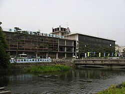
 Yamatokōriyama City Hall | |
 Location of Yamatokōriyama in Nara Prefecture | |
| Coordinates: 34°39′N 135°47′E / 34.650°N 135.783°E | |
| Country | Japan |
| Region | Kansai |
| Prefecture | Nara Prefecture |
| Government | |
| • Mayor | Kiyoshi Ueda |
| Area | |
| • Total | 42.69 km2 (16.48 sq mi) |
| Population (31 March 2017) | |
| • Total | 87,541 |
| • Density | 2,100/km2 (5,300/sq mi) |
| Time zone | UTC+09:00 (JST) |
| City hall address | 248-4 Kitakōriyama-chō, Yamatokōriyama-shi, Nara-ken 639–1198 |
| Website | www |
| Symbols | |
| Flower | Chrysanthemum Prunus jamasakura |
| Tree | Japanese Black Pine, Peking Willow |
Yamatokōriyama (大和郡山市, Yamatokōriyama-shi) is a city in Nara Prefecture, Japan. As of 30 September 2022[update], the city has an estimated population of 84,059 and 38,944 households.[1]
Geography[edit]
Yamato Koriyama is located in the northern part of the Nara Basin and stretches approximately 9 km from east to west and 7 km from north to south covering an area about 42 square kilometers.
Two rivers, the Saho River and the Tomio River flow through the city from north to south and merge into the Yamato River that flows westwards towards Osaka. The majority of the city is flat, although to the west of the Tomio River it rises to the Yata hills.
In general, the city has a temperate climate and is classified as having an "inland climate": a wide range of temperature bringing hot summers and cold winters, but heavy snows are rare, at most once a year.
There are 6 railway stations, (JR Koriyama, JR Yamatokoizumi, Kintetsu Koriyama, Kintetsu Kujo, Kintetsu Tsutsui, and Kintetsu Hirahata), and it takes about 40 minutes to travel to Osaka on the JR line and 45 minutes to Kyoto on the Kintetsu line. Nara is just one stop away on the JR line.
The city produces various agricultural, commercial, and factory products. For example, cultivation of rice and fresh vegetables such as strawberries and tomatoes is thriving. A large shopping mall on the edge of the city and many large shopping centres in the suburbs are sustaining commercial industry. The "Showa Kogyo Danchi,"[2] industrial zone, located in the southern part of the city is the largest in Nara Prefecture and employs a large number of workers. Recently, the numbers of laborers from Brazil and Asian countries such as Vietnam and Indonesia working there is on the increase.
Yamatokoriyama is well known for the cultivation of goldfish, a motif widely seen around the city.[3] In the Koriyama Castle site area, the original stone wall has remained intact for nearly 400 years, and the castle draws large numbers of visitors to the "Oshiro Matsuri" festival, which is held every year in the spring when the cherry blossoms are in full bloom.[4]
Neighboring municipalities[edit]

Yamatokōriyama adjoins the following municipalities.
Notable locations[edit]
Koriyama Castle[edit]

Construction of the castle was started by the Sengoku daimyō Tsutsui Junkei. Toyotomi Hidenaga later made it his residence and it became the headquarters of the Kōriyama Domain in the Edo period. The castle was held at various times by members of the Mizuno, Okudaira Matsudaira, Honda, Fujii Matsudaira, and Yanagisawa clans.
Shrines[edit]
- Meta Shrine
- Yanagisawa Shrine
- Kasuga Shrine
- Koizumi Shrine
Temples[edit]
- Matsuo-dera
- Yata-dera
- Jikō-in
- Kyūshō-ji
- Kakuan-ji
Other[edit]
- Dainagon-zuka (grave of Toyotomi Hidenaga)

Notable people[edit]
- Yanagisawa Yoriyasu, Japanese samurai of the Edo period
- Shigeru Joshima, Japanese musician, actor and guitarist, leader and member of the rock band Tokio
- Yoshinori Fujimoto, Japanese professional golfer (Japan Golf Tour)
- Kazuyoshi Shirahama, Japanese politician, member of the New Komeito Party, and member of the House of Councillors in the Diet (national legislature)
- Yoshimoto Ishin, Japanese businessman and Buddhist monk (Jōdo Shinshū)
- Yoshiyuki Kamei, Japanese professional baseball player for the Yomiuri Giants in Japan's Nippon Professional Baseball
- Sanae Takaichi, Japanese politician, member of the Liberal Democratic Party and member of the House of Representatives
Education[edit]
High schools[edit]
- Nara Gakuen[5]
- Kōriyama High School
- Yamatochūō High School
Junior high schools[edit]
- Kōriyama Junior High School
- Kōriyama-Minami Junior High School
- Kōriyama-Nishi Junior High School
- Kōriyama-Higashi Junior High School
- Katagiri Junior High School
Transportation[edit]
Rail[edit]
- West Japan Railway Company
- Kintetsu Railway
- Kashihara Line: Kujō Station – Kintetsu-Kōriyama Station – Tsutsui Station – Hirahata Station – Family-Kōemmae Station
- Tenri Line: Hirahata Station
Road[edit]
- Expressways
- Nishi-Meihan Expressway
- Keinawa Expressway (under construction)
 National Route 24
 National Route 25
 National Route 308
Cycling[edit]
The cycling route from Nara to Asuka designated by Nara Prefecture as Route C7 runs through the city.[6]
Sister cities[edit]
Yamatokōriyama has been twinned with Kōfu, Yamanashi, in Japan since 1992.[7] The two cities are twinned because during the Edo period the Yanagisawa family were transferred from Kofu to Yamatokoriyama under Kunigae (国替), a policy in which daimyōs were transferred from one post to the next.
References[edit]
- ^ "Official website of Yamatokōriyama city" (in Japanese). Japan: Yamatokōriyama City. Retrieved 9 October 2022.
- ^ 昭和工業団地協議会 Retrieved 18 June 2016.
- ^ Rocketnews Retrieved 18 June 2016
- ^ Yamatokoriyama City official website Retrieved 18 June 2016
- ^ Nara Gakuen English website Retrieved 18 June 2016
- ^ Nara cycling route C7 18 June 2016
- ^ Sister City Retrieved 7 November 2012.
External links[edit]
- Yamatokoriyama City official website (in Japanese)


