
File:Arabian Plate showing general tectonic and structural features, Infracambrian rift salt basins, and oil and gas fields of Central Arabia and North Gulf area.svg

Size of this PNG preview of this SVG file: 653 × 469 pixels. Other resolutions: 320 × 230 pixels | 640 × 460 pixels | 1,024 × 735 pixels | 1,280 × 919 pixels | 2,560 × 1,839 pixels.
Original file (SVG file, nominally 653 × 469 pixels, file size: 76 KB)
| This is a file from the Wikimedia Commons. Information from its description page there is shown below. Commons is a freely licensed media file repository. You can help. |
Summary
| Description |
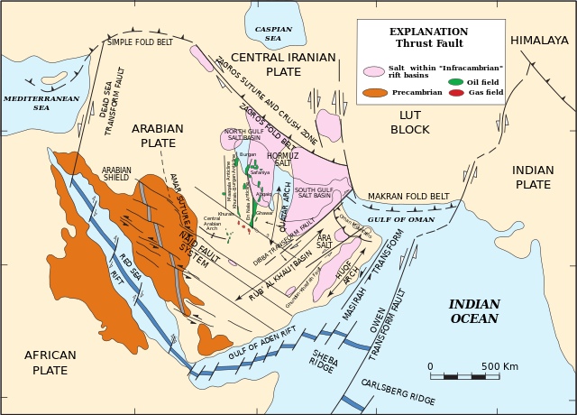
English: Arabian Plate showing general tectonic and structural features, Infracambrian rift salt basins, and oil and gas fields of Central Arabia and North Gulf area |
| Date | |
| Source | Pollastro, R.M. (2003) "Total Petroleum Systems of the Paleozoic and Jurassic, Greater Ghawar Uplift and Adjoining Provinces of Central Saudi Arabia and Northern Arabian-Persian Gulf", U.S. Geological Survey Bulletin 2202-H. https://pubs.usgs.gov/bul/b2202-h/b2202-h.pdf, page 14. |
| Author | Richard M. Pollastro |
Licensing
This image is in the public domain in the United States because it only contains materials that originally came from the United States Geological Survey, an agency of the United States Department of the Interior. For more information, see the official USGS copyright policy.
|
File history
Click on a date/time to view the file as it appeared at that time.
| Date/Time | Thumbnail | Dimensions | User | Comment | |
|---|---|---|---|---|---|
| current | 22:03, 21 March 2023 | | 653 × 469 (76 KB) | Sette-quattro | texts as objects |
| 13:53, 10 March 2023 |  | 512 × 396 (289 KB) | Sette-quattro | Uploaded a work by https://pubs.usgs.gov/bul/b2202-h/b2202-h.pdf from https://pubs.usgs.gov/bul/b2202-h/b2202-h.pdf with UploadWizard |
File usage
The following pages on the English Wikipedia use this file (pages on other projects are not listed):
Global file usage
The following other wikis use this file:
- Usage on de.wikipedia.org