Kukawa
Kukawa | |
|---|---|
| Coordinates: 12°55′N 13°34′E / 12.917°N 13.567°E | |
| Country | |
| State | Borno State |
| Founded | 1814 |
| Population (2006) | |
| • Total | 203,864 |
 | |
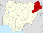
Kukawa (Kanuri for "Baobabs"), formerly Kuka ("Baobab"), is a town and Local Government Area in the northeastern Nigerian state of Borno, close to Lake Chad.
History
[edit]
The town was founded as Kuka in 1814 by Shehu Muhammad al-Amin al-Kanemi of the Bornu Empire. He intended for it to serve as his capital after the fall of the previous capital, Ngazargamu.[1] The town was the end of one of the main trans-Saharan trade routes to Tripoli on the Mediterranean coast.[2] It was visited by German explorer Heinrich Barth in 1851 who travelled from Tripoli seeking to open trade with Europe and explore Africa,[1] and again in 1892 by the French explorer Parfait-Louis Monteil, who was checking the borders between areas of West Africa assigned to the French and the British by the Treaty of Berlin.[3]

Historically the town was much larger than today, with a population estimated by the British at 50,000-60,000 in the late nineteenth-century. In the 19th-century, the expansion of a extramural suburb on the Dendal, the town's main road, caused the settlement to function as two towns, Kuka Futebe (Kanuri: "West Town") and Kuka Gedibe ("East Town").[4]: 125 The two towns were separated by a distance of about a kilometer or a half a mile. The Shehu and "other important persons" lived in the eastern town.[4]: 109 The dual settlement gradually caused the Kuka to be known as Kukawa, the plural form of its own name. The towns were captured and sacked in 1893 by the Sudanese warlord Rabih az-Zubayr, and then by the British in 1902.
On 16 January 2015, "caretaker chairman of Kukawa Local Government Area, Musa Alhaji Bukar Kukawa", speaking on behalf of the Kukawa residents who were displaced to Maiduguri following the 2015 Baga massacre, "called on the federal government to intensify military operations so that they can return to their homes."[5] A massacre occurred in Kukawa in July 2015.
Hundreds of Kukawa citizens were held hostage by the Islamic State West Africa Province (ISWAP) in August 2020. Two million people in Borno have been displaced from their homes over the past ten years; many live in squalid conditions in Maiduguri.[6]
Local Government Area
[edit]
Kukawa is one of the sixteen LGAs that constitute the Borno Emirate, a traditional state located in Borno State, Nigeria.[7] Other towns in the Kukawa Local Government Area include Cross Kauwa and Baga.
Climate
[edit]The weather is dry, with brief summers and pleasant winters, with temperatures between 59°F and 107°F and infrequently falling below 53°F or rising over 112°F.[8][9]
Heat waves, extreme weather, and rising temperatures are caused by climate change, although its effects are not uniform worldwide.[10]
References
[edit]- ^ a b Kemper, Steve (2012). Labyrinth of Kingdoms: 10,000 Miles Through Islamic Africa. New York: W. W. Norton. pp. 137–152. ISBN 978-0-393-07966-1.
- ^ J. D. Fage, ed. (1985). The Cambridge History of Africa, Volume 6. Cambridge University Press. p. 16. ISBN 9780521228039. Retrieved June 3, 2014.
- ^ Emil Lengyel (March 2007). Dakar - Outpost of Two Hemispheres. READ BOOKS, 2007. pp. 170ff. ISBN 978-1-4067-6146-7. Retrieved 2010-10-11.
- ^ a b Kirk-Greene, A. H. M. (Anthony Hamilton Millard) (1971). West African travels and adventures; two autobiographical narratives from Northern Nigeria. Internet Archive. New Haven, Yale University Press. ISBN 978-0-300-01426-6.
- ^ Hamza Idris and Yahaya Ibrahim. Nigeria: CBN, Nema Reach Out to Baga Attack Victims, Others. Daily Trust - allAfrica.com, January 16, 2015
- ^ "Nigerian army says 'in full control' of town where hostages taken". www.aljazeera.com. Retrieved August 20, 2020.
- ^ Nigeria (2000). Nigeria: a people united, a future assured. Vol. 2, State Surveys (Millennium ed.). Abuja, Nigeria: Federal Ministry of Information. p. 106. ISBN 9780104089.
- ^ "Kukawa Climate, Weather By Month, Average Temperature (Nigeria) - Weather Spark". weatherspark.com. Retrieved 2023-09-12.
- ^ "Kukawa, Borno, NG Climate Zone, Monthly Averages, Historical Weather Data". tcktcktck.org. Retrieved 2023-09-12.
- ^ "Climate Change Kukawa". meteoblue. Retrieved 2023-10-23.
12°55′N 13°34′E / 12.917°N 13.567°E


