
File:Mount Rainier Osceola collapse.png

Size of this preview: 800 × 591 pixels. Other resolutions: 320 × 236 pixels | 640 × 473 pixels | 864 × 638 pixels.
Original file (864 × 638 pixels, file size: 458 KB, MIME type: image/png)
| This is a file from the Wikimedia Commons. Information from its description page there is shown below. Commons is a freely licensed media file repository. You can help. |
Summary
| Description |
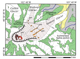
English: Detailed map of Mount Rainier's summit and northeast slope showing upper perimeter of Osceola collapse amphitheater (hachured line), approximate area of young summit cone (dashed line and shaded), Emmons–Winthrop high-Sr lava flows (orange), east summit crater lava flows (red and dotted line where concealed), west summit crater (mauve), area of summit hydrothermal alteration (cross pattern), Pleistocene lava flows (green), Tertiary basement (gray), and glacial deposits (yellow). Paleomagnetic measurement sites (pm) conducted by Vallance, TG is Tahoma Glacier. Contour interval 500 ft (152 m), index contours every 2,500 ft (762 m). Marginal ticks and internal crosses mark latitude and longitude. |
| Date | |
| Source | https://volcanoes.usgs.gov/volcanoes/mount_rainier/geo_hist_lahars.html |
| Author | United States Geological Survey |
This image is in the public domain in the United States because it only contains materials that originally came from the United States Geological Survey, an agency of the United States Department of the Interior. For more information, see the official USGS copyright policy.
|
File history
Click on a date/time to view the file as it appeared at that time.
| Date/Time | Thumbnail | Dimensions | User | Comment | |
|---|---|---|---|---|---|
| current | 06:38, 18 March 2018 | | 864 × 638 (458 KB) | Volcanoguy | {{Information |description ={{en|1=Detailed map of Mount Rainier's summit and northeast slope showing upper perimeter of Osceola collapse amphitheater (hachured line), approximate area of young summit cone (dashed line and shaded), Emmons–Winthrop high-Sr lava flows (orange), east summit crater lava flows (red and dotted line where concealed), west summit crater (mauve), area of summit hydrothermal alteration (cross pattern), Pleistocene lava flows (green), Tertiary basement (gray), and glacial deposits (yellow). Paleomagnetic measurement sites (pm) conducted by Vallance, TG is Tahoma Glacier. Contour interval 500 ft (152 m), index contours every 2,500 ft (762 m). Marginal ticks and internal crosses mark latitude and longitude.}} |source =https://volcanoes.usgs.gov/volcanoes/mount_rainier/geo_hist_lahars.html |author =United States Geological Survey |date =2009 }} {{PD-USGov-USGS}} Category:Maps of Mount Rainier |
File usage
The following pages on the English Wikipedia use this file (pages on other projects are not listed):
Global file usage
The following other wikis use this file:
- Usage on uk.wikipedia.org