
Wikipedia:Graphics Lab/Illustration workshop: Difference between revisions
→improve my picture clearity within 24 hours: new section |
m Marking 1 section stale; archiving 0 stale sections and 3 resolved sections. |
||
| Line 226: | Line 226: | ||
== Peter Island == |
== Peter Island == |
||
| ⚫ | |||
<center><gallery> |
<center><gallery> |
||
| Line 294: | Line 295: | ||
'''Graphist opinion:''' |
'''Graphist opinion:''' |
||
== Urdu alphabet / Devanagari == |
|||
<!-- nothing or {{resolved}} or {{Stale|user}} --> |
|||
<center><gallery> |
|||
File:Urdu alphabets.png|Urdu Alphabet (grainy) |
|||
File:Test-be-urdu.svg|Test svg character |
|||
File:Test-urdu5.svg|Test first line svg (with English diacritics) |
|||
</gallery></center> |
|||
'''Article(s):''' [[Urdu]] |
|||
'''Request:''' Could we make the Urdu script scale properly? SVG would be great, of course... but, a PNG where the Urdu script can scale to the proper size would be great. [[User:Grenavitar|gren]] [[User talk:Grenavitar|グレン]] 00:37, 11 May 2009 (UTC) |
|||
'''Graphist opinion(s):''' {{I take|Goldsztajn}} Hi, a little complicated this request, but I've had a try and came up with the "be" character (although the Devanagari part is not quite correct yet). Nevertheless it's doable for me, I'll just be a little slow. Without the Devanagari phonetics it would be easier... :) Regards --[[User:Goldsztajn|Goldsztajn]] ([[User talk:Goldsztajn|talk]]) 10:08, 11 May 2009 (UTC) |
|||
::Looks very good to me... and I see nothing wrong with the Devanagari (the loop closes in the PNG but not the SVG... but, that seems a matter of font and not of correctness). Thank you for working on this. I think it will be useful to have an SVG... unless you think it's better just to put this on the page in a table not using an image. But, Images are nice because you can print them out more easily. [[User:Grenavitar|gren]] [[User talk:Grenavitar|グレン]] 10:25, 11 May 2009 (UTC) |
|||
:::It was ok, but not perfect as the accent on the Devanagari character was not displaying in the proper place, but with this second test file I seem to have solved that and now have all the Urdu/Hindi characters and accents displaying properly...just need to get English correct! --[[User:Goldsztajn|Goldsztajn]] ([[User talk:Goldsztajn|talk]]) 00:50, 12 May 2009 (UTC) |
|||
::::First line completed, with diacritics and correct English.--[[User:Goldsztajn|Goldsztajn]] ([[User talk:Goldsztajn|talk]]) 09:30, 13 May 2009 (UTC) |
|||
<!-- This area is for wikigraphists: |
|||
: when youn accept the request ; |
|||
{{Done}}: when the request is done. --> |
|||
== Spouting can == |
== Spouting can == |
||
| Line 338: | Line 318: | ||
::::{{done}} '''<font color="navy" face="comic sans ms">[[User:ZooFari|Zoo]]</font><font color="orange" face="comic sans ms">[[User:ZooFari|Fari]]</font>''' 00:43, 16 May 2009 (UTC) |
::::{{done}} '''<font color="navy" face="comic sans ms">[[User:ZooFari|Zoo]]</font><font color="orange" face="comic sans ms">[[User:ZooFari|Fari]]</font>''' 00:43, 16 May 2009 (UTC) |
||
== Clifton Townsite == |
|||
<!-- nothing or {{resolved}} or {{Stale|user}} --> |
|||
<center><gallery> |
|||
File:Clifton Townsite Historic District.jpg|Overview of part of [[Clifton, Arizona]] |
|||
</gallery></center> |
|||
'''Article(s):''' [[National Register of Historic Places listings in Greenlee County, Arizona]], potentially [[Clifton Townsite Historic District]] |
|||
'''Request:''' Remove the little squiggle and what looks like the results of a miniature ring binding in the top left corner. [[User:Nyttend|Nyttend]] ([[User talk:Nyttend|talk]]) 20:10, 12 May 2009 (UTC) |
|||
'''Graphist opinion(s):''' Done. '''[[User:Mmxx|<span style='color:#006;background-color:#E6E6FA;'> ■ MMXX</span>]]'''<sup>[[User talk:Mmxx|''<span style='color: #006;'>talk</span>'']] </sup> 15:51, 13 May 2009 (UTC) |
|||
<!-- This area is for wikigraphists: |
|||
{{I take|name}}: when youn accept the request ; |
|||
{{Done}}: when the request is done. --> |
|||
== A-Class icons == |
|||
| ⚫ | |||
<center><gallery> |
|||
File:GA candidate.svg|Would like icons similar to this... |
|||
File:Symbol unsupport vote.svg|...and this... |
|||
File:Symbol a class.svg|...but for A-Class. |
|||
File:A candidate.svg |
|||
File:Symbol unsupport A vote.svg |
|||
</gallery></center> |
|||
'''Request:''' Would it be possible for someone to create icons for A-Class candidates and failed A-Class candidates, similar to those used for Good Articles? Primarily I would like to use such icons for the A-Class review department of [[WP:FILM]], but naturally their use would extend elsewhere as well. Thanks in advance! [[User:PC78|PC78]] ([[User talk:PC78|talk]]) 07:37, 13 May 2009 (UTC) |
|||
'''Graphist opinion(s):''' |
|||
Hows that? [[User:Pbroks13|<b><font color="#92000a">--Pbroks13</font></b>]]<sup>[[User talk:Pbroks13|<font color="#CBA135">talk?</font>]]</sup> 19:13, 13 May 2009 (UTC) |
|||
:Superb! Thanks! :) [[User:PC78|PC78]] ([[User talk:PC78|talk]]) 21:27, 13 May 2009 (UTC) |
|||
== Marugame in Kagawa prefecture == |
== Marugame in Kagawa prefecture == |
||
Revision as of 07:08, 17 May 2009
This page is deprecated and will not be monitored. Please use one of the three workshop pages. This specific page is {{{1}}}
Map of Roman Empire
- Article: Roman roads in Africa
- Map

- Request: Could anyone help me by cutting off the top part of the map (just below Gibraltar) and putting the frame with explanations of the symbols etc. that is now in the upper right corner over the frame that is now in the lower left corner (excluding the title "Roman empire in 45 AD" and everything below the word Colchis). I would be very grateful.S711 (talk) 07:55, 31 March 2009 (UTC)
Won't you pleease help me, help me?S711 (talk) 19:19, 3 April 2009 (UTC)
Graphist opinion: Hi S711, for me this is actually a fair amount of work, it is not a simple crop and move job, especially if it is to be left as an SVG. Unless another graphist wants to have a go at this, I'll try to get to it over the next week, but if others have any views for a speedy solution here, please chip in.--Goldsztajn (talk) 03:18, 4 April 2009 (UTC)
- Great!!S711 (talk) 10:49, 4 April 2009 (UTC)
- Yes that is a pretty horrible task due to the fact that everything is a vector outline, and nothing seems to be collected into complete outlines. Mfield (Oi!) 07:12, 9 April 2009 (UTC)
- The simplest/quickest way would be to move the legend, group all the map objects together and add a rectangle around the area needed then select both objects and do Object > Clip > Set. That will only hide the rest of the map though, it'll still be a massive file size-wise. So if the rest of the text really isn't needed then most of that could be deleted before clipping to the correct area. — ₪₪ ch1902 ₪₪ 10:32, 9 April 2009 (UTC)
- If it would make things easier only the names of the cities could remain and the legend could be left out altogether.S711 (talk) 11:41, 11 April 2009 (UTC)
- The simplest/quickest way would be to move the legend, group all the map objects together and add a rectangle around the area needed then select both objects and do Object > Clip > Set. That will only hide the rest of the map though, it'll still be a massive file size-wise. So if the rest of the text really isn't needed then most of that could be deleted before clipping to the correct area. — ₪₪ ch1902 ₪₪ 10:32, 9 April 2009 (UTC)
IMPORTANT: this map is still frequently edit by user:Andrei nacu and user:Richardprins, request them to edit the map, or to give their opinion is a better way to process. Yug (talk) 23:18, 15 April 2009 (UTC)
- I tried, but without success.S711 (talk) 18:14, 18 April 2009 (UTC)
- Isn't there anyone who wants to try? How about it Goldsztajn, you wrote you would get to it, some weeks ago.S711 (talk) 10:39, 5 May 2009 (UTC)
- Help me then, at least, with a simple horizontal cut through the middle.S711 (talk) 10:58, 5 May 2009 (UTC)
- I'm sorry, but I think it is better if the original author/s do/es this given the comments above. --Goldsztajn (talk) 05:10, 6 May 2009 (UTC)
- Is nobody able or willing to simply halve this map? Very disappointing.S711 (talk) 21:27, 10 May 2009 (UTC)
- I'm sorry, but I think it is better if the original author/s do/es this given the comments above. --Goldsztajn (talk) 05:10, 6 May 2009 (UTC)
- Help me then, at least, with a simple horizontal cut through the middle.S711 (talk) 10:58, 5 May 2009 (UTC)
- Isn't there anyone who wants to try? How about it Goldsztajn, you wrote you would get to it, some weeks ago.S711 (talk) 10:39, 5 May 2009 (UTC)
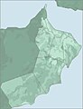
Oman
-
 PNG map of Oman, and its location relative to the rest of the world.
 -
 JPG detailed map of Oman, showing its exlaves
 -
 SVG with enclaves


Article(s): Oman
Request: The first map doesn't show Oman's two exclaves (areas of Oman within the United Arab Emirates. Could the map (a) be modified to show these areas, and (b) be converted to an SVG? The second map can be used to determine the location of the exclaves. For bonus points, the second map is a JPEG and could really do with being converted to an SVG - but now I'm just pushing my luck ;-) I don't know if it's relevant, but the first map comes from Commons - commons:File:LocationOman.png- if I need to make the request there let me know (I've watchlisted this page, or you can ping me on my talk page. Cheers, This flag once was redpropagandadeeds 14:36, 6 April 2009 (UTC)
Graphist opinion: There's an SVG version of the location map, it will need to be shown I'd guess at least at 700-800px for both the enclaves to be visible.--Goldsztajn (talk) 01:56, 8 April 2009 (UTC)
- Awesome! I think that so long as a user clicking on the map (and seeing an enlarged version) can see the exclaves then that should be fine. Thanks for your work on this, it's appreciated. Cheers, This flag once was redpropagandadeeds 14:37, 8 April 2009 (UTC)
- I've made the nominal size larger (from 600px to 1000px), this way one click to the image will reveal the external territories (rather than having to click and zoom).--Goldsztajn (talk) 01:14, 9 April 2009 (UTC)
WW2 disease awareness poster
![]() Not done
Not done
-
 Photo with camera flash
 -
Photo without camera flash

Article(s): Food poisoning and related
Request: I took both photos from the Australian War Memorial. The previous version (see file history) was very dark; the current version is clearer and brighter, however has an obvious camera flash obstructing everything. Is it possible that this can be fixed? -- 李博杰 | —Talk contribs email guestbook complaints 07:59, 11 April 2009 (UTC)
Graphist opinion: Sorry, but as far as I can tell you must have permission from the AWM to reproduce its images, it cannot be assumed this is public domain. --Goldsztajn (talk) 09:39, 11 April 2009 (UTC)
- Adding a "not done" tag, re license issue.--Goldsztajn (talk) 07:40, 22 April 2009 (UTC)
- Note: if the poster itself is public domain, the AWM's claim to it is illegitimate (this kind of false claim is common practice among museums). We need to determine the actual copyright holder of the poster. Dcoetzee 02:01, 1 May 2009 (UTC)
- Adding a "not done" tag, re license issue.--Goldsztajn (talk) 07:40, 22 April 2009 (UTC)
Nintendo DSi
Article(s): Nintendo DSi
Request: This should be quick, easy and fun. If possible make into vector to allow this image to be used in place of the poor free version. It'd also be nice, but not mandatory to have shoulder lights illuminated [1] -- penubag (talk) 21:41, 15 April 2009 (UTC)
Graphist opinion: I spent about 10 minutes tracing this, but it's nowhere near done yet. If someone else wants to improve on it, please do. Cheers, Paranomia (talk) 23:53, 27 April 2009 (UTC)
- I made one. It is at File:Dsi white closed upright.svg. Tell me what you think :P. --Goldblattster (talk) 19:05, 29 April 2009 (UTC)
- Both of yours are good. Paranomia's was created from scratch and Goldblatter's was bitmap traced. I think I'll take Paranomia's and incorporate elements from Gold's and make a realistic looking finish. Thanks! -- penubag (talk) 23:22, 29 April 2009 (UTC)
Lymph Node Structure
-
 Cross Section of a lymph node

Article(s): Lymph node , and 93 more.
Request: If this could be SVGd,as it suffers from lossy compression effects, that would be great... Connormah (talk) 23:58, 16 April 2009 (UTC)
Graphist opinion:
The first version is here. Feedback would be nice before I update the .png version with this. -綾波風神 (talk) 16:00, 24 April 2009 (UTC)
- Valves in the afferent vessels should have a line in the middle to indicate that they can open. I think that there are also valves in the efferent vessels (bottom), they're just shown wide open so you can't see them well on this small pic. --Yerpo (talk) 19:48, 28 April 2009 (UTC)
Image of Wikia founders needed
-
 Beesley, Wales and two additional figures

Article(s): Wikia, Jimmy Wales
Request:
Greetings, I'm looking for a decent-quality image of Wikia founders Jimmy Wales and Angela Beesley. The best I could find is File:Angela Jimbo Piotrus - Wikimania 2006.jpg, but that includes unnecessary detail and is rather grainy. If there are no superior alternatives, could someone see if they could improve this image? Thanks, Skomorokh 14:44, 20 April 2009 (UTC)
Graphist opinion: Sorry there's been no reply to this. Could you not combine (or use next to each other) their official portraits? That photo above is not at all flattering to either of them, and can't be improved much. Note also that Angela is Mrs Beesley Starling now, since marrying Tim. —Vanderdecken∴ ∫ξφ 12:01, 3 May 2009 (UTC)
- Thanks for the feedback. My main concern is the Jimmy Wales article, where dual portraits would not be a great help. Skomorokh 20:10, 7 May 2009 (UTC)
University of Valle Maps
Article(s): University of Valle#Campus
Request: Greetings. I'm completing the university article, and I would like to add the maps for the two largest campus, that are available in these websites as PDF files: Melendez Campus and San Fernando Campus. Both maps are in Spanish, and I'll be glad to help in the translation of the names. Regards, Andremun (talk) 00:32, 26 April 2009 (UTC)
Graphist opinion: Here they are as PNGs: [2] [3]. But before I go ahead and upload/translate them, what is the licensing for each of these? Paranomia (talk) 13:20, 26 April 2009 (UTC)
This is what Goldsztajn found out about the Colombian Copyright, Law, 28/01/1982, No. 23, regarding a previous project:
Article 41. Any person shall be allowed to reproduce the Constitution, laws, decrees, ordinances, orders, regulations and other administrative texts and judicial decisions, subject to the obligation to abide strictly by the official edition, and provided that such reproduction is not prohibited.
The university is a public institution, and because of that, its materials can be thought as administrative documents. Also, I don't know if these can be vectorized, and the background color or texture changed. Regards -Andremun (talk) 16:02, 26 April 2009 (UTC)
- No worries, I already have vector versions - I just uploaded them as PNG to avoid rendering errors. Also, I'm assuming that we're still abiding strictly by the official edition when translating/tweaking these maps, right? Anyway, here they are: Image:Melendez Campus.svg and Image:San Fernando Campus.svg. You can translate them with this tool, or you can manually post the translations and I'll do my best to change it. I also strongly recommend you use PNG versions once everything is translated. Cheers, Paranomia (talk) 21:00, 26 April 2009 (UTC)
- I see why you suggest to use PNG. These files are quite large. I tried to use the tool that you suggested, but it seems that I messed up a bit. I will upload them translated, and some editing must be done to organize them, specially the font size. I'm not sure what you mean by "abiding strictly", but I think for presentation, some edits have to be made. Thanks for the work so far! Regards -Andremun (talk) 21:43, 26 April 2009 (UTC)
- OK, just post here when you have the translated versions uploaded. Paranomia (talk) 22:23, 26 April 2009 (UTC)
- Hello. I've uploaded the new versions for the Image:Melendez Campus.svg and Image:San Fernando Campus.svg. If for some reason, they appear in spanish, please click in the image to see the translation. Regards -Andremun (talk) 05:20, 29 April 2009 (UTC)
- Hmm, the image seems to be having problems with the text when rendering to PNG. How did you translate them (with Inkscape, the translation tool, or something else)? Paranomia (talk) 22:11, 1 May 2009 (UTC)
- Hello. I used the translation tool suggested. -Andremun (talk) 03:22, 2 May 2009 (UTC)
- Sorry for the late reply. I don't think I can help you too much anymore, I'm a bit busy in real life and I'm not sure what the problem is. Does anyone else have a suggestion? Paranomia (talk) 15:08, 10 May 2009 (UTC)
Old map
Article(s): Jesuit Missions of the Chiquitos
Request: I would like to use the map from WDL or the original source in the above article. However I cannot find a way to get at the full map in high resolution. The 3MB tif at the WDL-site has too little resolution as has the jpg at the Brazilian library site (original source). Am I missing a link to the original hi-res source? If I zoom in with the zoom viewer I can save parts of the map (screensize) by just right-clicking and "save image as". However my screen is too small to fit the whole map in reasonable resolution. Maybe a Portuguese speaker can figure out the library site, or somebody with a big screen could help. Please let me know how I can get at a high resolution file of the map or upload it yourself (as {{PD-Art}}). Thanks. bamse (talk) 00:09, 27 April 2009 (UTC)
Graphist opinion:
Latin America map
-
 Countrys of Latin America
 -


Article(s): Latin America
Request: The svg version should have French Guyana in green as png version. Though it is a French dependance, as Puerto Rico is of USA, it belongs to Latin America
Graphist opinion: Done, I added French Guyana and the French islands in the Caribbean, I subtracted some English and Dutch speaking islands that had been shaded. Kmusser (talk) 14:26, 27 April 2009 (UTC)
Wikipedia:WikiProject American Football League

Article(s): Wikipedia:WikiProject American Football League
Request: please match fonts and center, drawn from different logo... Chris (クリス • フィッチュ) (talk) 05:41, 29 April 2009 (UTC)
Graphist opinion:
Irridescent Canadia
Article(s): Fossils of the Burgess Shale, Canadia, various others to do with Burgess Shale; possibly articles on evolution of vision, as the colourful display in the NHM artcile makes little sense if nothing was capable of seeing and recognising it.
Request: Like the one at the top of Colouring in the fossil past. It's the centenary of the discovery of the Burgess Shale this year, so a buddy and I fancy an FA or two on it. --Philcha (talk) 06:50, 29 April 2009 (UTC)
Excuse me, what's the meaning of the "stale" flag? --Philcha (talk) 11:40, 13 May 2009 (UTC)
- Means that the request has been there for a fortnight without any activity and without being resolved. Stannered (talk) 14:39, 13 May 2009 (UTC)
- What does that imply about its prospects? --Philcha (talk) 15:38, 13 May 2009 (UTC)
Graphist opinion:
University of Oslo seal
-
 Seal of the University of Oslo (1842)

Article(s): University of Oslo
Request: File:Seal_of_the_University_of_Oslo.jpg is from 1842 and in the public domain, but in very low quality. If someone could redraw it in better quality, without background, it would be great - a free version of the university seal, that can be uploaded to Commons and used on other projects which do not allow fair use, would be greatly appreciated. The seal shows Apollo with the Lyre, and the text is "UNIVERSITAS REGIA FREDERICIANA". Also see the modern (non-free, fair use) version here (but the new image should be based on the free 1842 version). JY890 (talk) 00:11, 30 April 2009 (UTC)
Graphist opinion: Quality is too low. Any higher quality links/scans possible? JaakobouChalk Talk 00:52, 10 May 2009 (UTC)
- A better quality version of the free 1842 version isn't available, but check out this drawing of the seal, used in a 1926 Festschrift, which is almost the same. A redrawed version doesn't have to be 100 % identical to the 1842 version, the important thing is the motive (Apollo with the Lyre), and the text UNIVERSITAS REGIA FREDERICIANA. JY890 (talk) 21:38, 10 May 2009 (UTC)
Peter Island
-
2nd image (If there is one)
Article(s): Peter Island
Request: Upload from Flickr and crop 92.8.99.201 (talk) 21:25, 30 April 2009 (UTC)
Graphist opinion: Can't do that - although the photograph on Flickr isn't copyrighted, and its CC-BY 2.0 license is compatible with Wikipedia (and Commons), the map may be copyrighted or any other license we can't accept. Sorry. —Vanderdecken∴ ∫ξφ 18:58, 2 May 2009 (UTC)
- I agree, and us uploading content from other places puts risk on us and not the requester. ZooFari 00:44, 3 May 2009 (UTC)
Poll tax reciept

Articels: Poll tax
Request: Center and crop; also, can the light level be adjusted? It looks a little darker in the lower right corner. 76.117.247.55 (talk) 01:05, 6 May 2009 (UTC)
Oppinion: How's that? --Goldsztajn (talk) 05:28, 8 May 2009 (UTC)
- Was quite good but I felt levels needed some extra work on the lower right side. Sorry for kind-of stepping on your work - no offense intended. JaakobouChalk Talk 02:21, 10 May 2009 (UTC)
- No offense taken; but by pushing the levels this much and/or your cropping the delineation of the actual receipt itself is no longer visible. However, the requester can make a choice or ask for something different if not satisfied with this or my earlier version.--Goldsztajn (talk) 12:10, 10 May 2009 (UTC)
- It is improved now, however if you can also improve it, it's worth a try. 76.117.247.55 (talk) 20:36, 10 May 2009 (UTC)
Psycrometrics chart

Articels: Psychrometrics
Request: SVGify this fun thing. 76.117.247.55 (talk) 05:04, 8 May 2009 (UTC)
Oppinion:
Seats in the European Parliament
Article(s): European Parliament, Member of the European Parliament, election articles etc.
Request: Please, could anyone make an SVG with where each number is replaced by a small circle (or like this). We could use it to illustrate the composition of the parliament by colouring them. SSJ ☎ 14:51, 9 May 2009 (UTC)
Graphist opinion:
Nagy Lajos királyságai.JPG
-
 Kingdoms of Nagy lajos (Louis I of Hungary) or Poland and Hungary in 1360.

Article(s): Louis I of Hungary
Request: Hello! I would like to request some help from the editors. Is it possible to create "modern" image from it, something like this one [5] or make a new one form this blank Europe map? [BlankMap-Europe.png] Thank you very much! Description: The "red line" marks the borders of Hungary and Poland (under personal union), "Lengyel Királyság" means: Kingdom of Poland, Magyar Királyság means: Kingdom of Hungary. "Hűbéres and húbéres területek" are the yellow areas, they are the vassal states of Hungary (Moldavia, Wallachia, Bosnia, and Serbia). Yellow line: border of the vassal states.Baxter9 (talk) 21:22, 10 May 2009 (UTC)
Graphist opinion:
Spouting can
-
 A spouting can
 -
 SVG by ZooFari


Article(s): Spouting can
Request: SVG-ify (and prettify too, while you're at it). Headbomb {ταλκκοντριβς – WP Physics} 13:51, 12 May 2009 (UTC)
- Also, the water path should be parabolic instead of the current "straight for a while, then suddenly down" . Headbomb {ταλκκοντριβς – WP Physics} 13:54, 12 May 2009 (UTC)
Graphist opinion(s):
- I will have this ready by tonight. ZooFari 00:34, 14 May 2009 (UTC)
- Okay, how is that? ZooFari 14:19, 14 May 2009 (UTC)
- Looks good to me. You can upload under the old file name, or delete the older file and updates existings links. Don't know really what's the procedure here...Headbomb {ταλκκοντριβς – WP Physics} 14:51, 14 May 2009 (UTC)
- Okay, how is that? ZooFari 14:19, 14 May 2009 (UTC)
Marugame in Kagawa prefecture

Article(s): Marugame, Kagawa
Request: Change text from Italian to English... Chris (クリス • フィッチュ) (talk) 18:29, 13 May 2009 (UTC)
Graphist opinion:
Map of Europe and North Africa
-
 Map 1: should be improved (svg)
 -
 Map 2: should be superseded
by map 1 (jpg) -
 Map 3: All EU member states' borders traced by hand
 -
 Map 4: Uncropped version of map 3; no national borders traced
 -
 Map 5: All countries are individual objects
 -
 Map 6: Africa included, mercator projection, individual countries traced


_EN.svg)
.svg)


Article(s): Union for the Mediterranean, European Neighbourhood Policy etc.
Request: Can someone improve map 1, so that it's possible to use it not only for the Union for the Mediterranean but also for other European organizations like shown on map 2? (The countries / objects are not defined properly.) Kolja21 (talk) 03:12, 15 May 2009 (UTC)
Graphist opinion: It takes a lot of time to trace all national borders by hand. But I have done it with all EU member states in this map (you can redefine the crop in Inkscape). If you want a template blank map where this has been already done for all countries, chech out File:Location European nation states.svg (though that map isn't as big geographically). Do you want a specific map or just a perfect blank map? - SSJ ☎ 15:56, 15 May 2009 (UTC)
- A perfect blank map would be perfect ;-) Your Europe and world maps are great, but a "perfect" one for Europe and North Africa (map 1 is based on your work) is missing. --Kolja21 (talk) 16:42, 15 May 2009 (UTC)
Make the background trasparent
-
 Mask for composite icons

Article(s): Huge number of link
Request: Could someone please make this file transparent, File:Soccerball mask.svg ? As for the soccerball, I want the background to be transparent because it take up spaces. If it can't be transparent, maybe any of you can help me to cut a bit the white background so that it fits the soccerball size. The file is from commons, and if any of you know any help pages that you think you can forward this question to, fell free to do it. Arteyu ? Blame it on me ! 10:21, 15 May 2009 (UTC) I think you doesn't have to make it trasparent, better to cut a bit the white background so that it fits the soccerball size, do not make it transparent. Thanks Arteyu ? Blame it on me ! 22:21, 15 May 2009 (UTC)
Graphist opinion: While I can't help with this request myself, I should point out that this template is used in {{Soccer icon}} which is in turn used in a multitude of stub templates. The background cannot be transparent because the ball is, and trimming too much of the whitespace may have an adverse effect. However, I do agree that the template is less than perfect; while it may prevent the need to have individual icons for each and every country, the end result is rather more cumbersome than an individual icon would be. PC78 (talk) 14:33, 16 May 2009 (UTC)
- It's okay if it cannot be done. But the image just take up so much spaces. I hope that some of you can figure out how a new file can be made without taking up spaces (that can replace this one that is being used on stubs. Thanks anyway (: Arteyu ? Blame it on me ! 17:01, 16 May 2009 (UTC)
Nott Memorial
-
 Original
 -
Color Correction
-
And some perspective/barrel touchups

Article(s): Nott Memorial, Union College
Request: Remove barrel distortion, please. And update in any way you deem necessary. wadester16 | Talk→ 17:56, 15 May 2009 (UTC)
Graphist opinion(s): I don't think it needs distortion removal, that'll reduce quality on the larger image. It seems a bit, meticulous. --Blacklemon67 (talk) 22:46, 15 May 2009 (UTC)
- Thought I'd play around with it a bit. Posting two output files - let me know if you like any of them. JaakobouChalk Talk 06:09, 16 May 2009 (UTC)
- No. 3 works great; thanks! wadester16 | Talk→ 06:30, 16 May 2009 (UTC)
Australia map with soccerball nad New Zealand flag with soccerball
-
 South America map with soccerball
 -
 Scotland flag with soccerball


Article(s): Template:Australia-sport-bio-stub & Template:NZ-sport-bio-stub
Request: I found these files on commons, I want to request that the South America map to be changed to Australian and the Scotland flag to be changed with New Zealand. I want to use it on template. I hope that you can make it as creative as possible. Any other idea for the template are welcomed. Thanks Arteyu ? Blame it on me ! 03:11, 16 May 2009 (UTC)
Graphist opinion:
Convert the first & the 2nd file to SVG
-
 Penang state in red (PNG)
 -
 Sarawak state in red (PNG)
 -
 Selangor state in red (SVG)
 -
 Penang state in red (SVG)
 -
 Sarawak state in red (SVG)
Article(s): Penang
Request: I want the Penang map & the Sarawak map(the first & the 2nd file) to be converted into SVG similar the third file. Thanks Arteyu ? Blame it on me ! 03:35, 16 May 2009 (UTC)
Graphist opinion: Done, with border colors standardized to WP:WPMAP guidelines. I can't vouch for the accuracy of the original SVG's outlines, though. Fvasconcellos (t·c) 15:36, 16 May 2009 (UTC)
- Wow, thats great. Thanks ! Arteyu ? Blame it on me ! 16:56, 16 May 2009 (UTC)
The original map in JPEG is wrong
-
 Penang state map

![[1]](http://buy-dsi.com/img/compare-dsi-ds-lite.jpg)
![[2]](http://img141.imageshack.us/img141/2339/mapv.png)
![[3]](http://img408.imageshack.us/img408/6813/map2.png)
![[4]](http://www.europarl.europa.eu/eplive/expert/photo/20070912PHT10318/pict_20070912PHT10318.jpg)
![[5]](https://en.wikipedia.org/wiki/File:Map_of_Hungary_in_1490.png)
Article(s): Penang
Request: Hi! It's me again. I just want to point out that the location name for the file above is wrong. Firstly, the island part of the state is not called "Pulau Penang" as in the map. The actual name of island part is "Pulau Pinang" (in Malay) or "Penang Island" (in English). The peninsular part of the state is known as "Seberang Perai", not "Penang" as stated in the map. The state as a whole is known as "Penang" in English. Another mistake that I've seen in the map is with the name of the capital of Penang. It should be "Georgetown", doesn't have any spaces between the "George" and the "Town" word.
My request is to create two map similar to that in PNG or SVG with no road lines (the lines in white and gray).
First map in detail: To create a new Penang map with no location names (no font at all & no road lines). If can don't make it black and white. Make it in colour. Also, I don't want the compass (the North locator or whatever you call it to be in the map).
Second map in detail: To create a new Penang map with location names (only state the Penang Island part, the Seberang Perai part and the Georgetown capital). Also, if can don't make it black and white. Make it in colour.
And if possible can you also make a map showing only the Penang island? I want to put it on this article — Penang Island.
That's all, thanks (: Arteyu ? Blame it on me ! 19:43, 16 May 2009 (UTC)
Graphist opinion:
improve my picture clearity within 24 hours
-
Description of image
-
2nd image (If there is one)
-
Don't request too many at once, though
Article(s): Brazil
Request: Do something with them... 220.224.106.246 (talk) 06:12, 17 May 2009 (UTC)
Graphist opinion(s):