
Holborn: Difference between revisions
m delinking ISO style dates using AWB |
Correct pronunciation +cite. The last syllable is usually pronounced like "bun" not "burn" |
||
| Line 1: | Line 1: | ||
otheruses}} |
|||
{{Infobox UK place| |
{{Infobox UK place| |
||
|country = England |
|country = England |
||
| Line 18: | Line 18: | ||
|os_grid_reference= TQ305815 |
|os_grid_reference= TQ305815 |
||
}} |
}} |
||
'''Holborn''' ({{pron-en| |
'''Holborn''' ({{pron-en|ˈhoʊbən}} {{respell|HOE|bən}})<ref name="Pronunc">{{cite book|last=Roberts|first=Andrew|coauthors=Matthew Teller|title=The Rough Guide to Britain|publisher=Rough Guides Ltd|location=London|date=2004|pages=109|isbn=1843533014 |accessdate=18 November 2009}}</ref>{{ is an area of [[Central London]], England. Holborn is also the name of the area's principal east-west street, running from St Giles's High Street as High Holborn to Gray's Inn Road to [[Holborn Viaduct]], crossing the borders of the [[City of Westminster]], [[London Borough of Camden]] and the [[City of London]]. |
||
==History== |
==History== |
||
Revision as of 17:19, 18 November 2009
otheruses}}
Holborn (Template:Pron-en HOE-bən)[1]{{ is an area of Central London, England. Holborn is also the name of the area's principal east-west street, running from St Giles's High Street as High Holborn to Gray's Inn Road to Holborn Viaduct, crossing the borders of the City of Westminster, London Borough of Camden and the City of London.
History

The area's first mention is in a charter of Westminster Abbey, by King Edgar, dated to 959. This mentions "the old wooden church of St Andrew" (St Andrew, Holborn).[2] It was then outside the City's jurisdiction and a part of Ossulstone Hundred in Middlesex. In the 12th century St Andrew's was noted in local title deeds as lying on "Holburnestrate"—Holborn Street.[3]
The name Holborn may be derived from the Middle English "hol" for hollow, and bourne, a brook, referring to the River Fleet as it ran through a steep valley to the east.[2][4] The 16th century historian John Stow attributes the name to the Old Bourne ("old brook"), a small stream which he believed ran into the Fleet at Holborn Bridge, a structure lost when the river was culverted in 1732. The exact course of the stream is uncertain, but according to Stow it started in one of the many small springs near Holborn Bar, the old City toll gate on the summit of Holborn Hill.[4][5] Other historians, however, doubt that in view of the slope of the land.[6]
The original Bars were the boundary of the City of London from 1223, when the City's jurisdiction was extended beyond the Walls, at Newgate, into the suburb here, as far as the point where the Bars where erected, until 1994 when the border moved to the junction of Chancery Lane. In 1394 the Ward of Farringdon Without was created, but only the south side of Holborn was under its jurisdiction with some minor properties, such as parts of Furnival's Inn, on the northern side, "above Bars". The rest of the area "below Bars" (outside the City's jurisdiction) was organised by the vestry board of St Andrew's parish.[7] Thus the original part of Holborn was never incorporated into the Metropolitan Borough of Holborn. The Metropolitan Borough of Holborn was created in 1899. It was abolished in 1965 and its area now forms part of the London Borough of Camden.
In the 18th century, Holborn was the location of the infamous Mother Clap's molly house but in the modern era High Holborn has become a centre for entertainment venues to suit more general tastes: 22 inns or taverns were recorded in the 1860s and the Holborn Empire, originally Weston's Music Hall, stood between 1857 and 1960, when it was pulled down after structural damage sustained in the Blitz. The theatre premièred the first full-length feature film in 1914, The World, the Flesh and the Devil, a 50-minute melodrama filmed in Kinemacolour.[8]
Charles Dickens took up residence in Furnival's Inn, on the site of the former Prudential building designed by Alfred Waterhouse and named "Holborn Bars". Dickens also put his character "Pip", in Great Expectations, in residence at Barnard's Inn opposite, the current home of Gresham College, and Staple Inn, notable as the promotional image for "Old Holborn" tobacco. The three of these were Inns of Chancery. The most northerly of the Inns of Court, Gray's Inn, is in Holborn, as is Lincoln's Inn: the area has been associated with the legal professions since mediaeval times. Subsequently the area diversified and become recognisable as the modern street. A plaque stands at number 120 commemorating Thomas Earnshaw's invention of the Marine chronometer, which facilitated long-distance travel. At the corner of Hatton Garden was the old family department store of Gamages. Until 1992, the London Weather Centre was located in the street. The Prudential insurance company relocated in 2002. The Daily Mirror offices used to be directly opposite it, but the site is now occupied by the J Sainsbury head office.
Further east, in the gated avenue of Ely Place, is St Etheldreda's Church, originally the chapel of the Bishop of Ely’s London palace. This ecclesiastical connection allowed the street to remain part of the county of Cambridgeshire until the mid 1930s. This meant that the Mitre Tavern, located in a court hidden behind the buildings of the Place and the Garden was subject to the Cambridgeshire Magistrates to grant its licence.[9][10] St Etheldreda's is the oldest church building used for Roman Catholic worship in London, but this became so only after it ceased to be an Anglican chapel in the 19th century.
Hatton Garden, the centre of the diamond trade, was leased to a favourite of Queen Elizabeth, Sir Christopher Hatton at the insistence of the Queen to provide him with an income. Behind the Prudential Building lies the Anglo-Catholic church of St Alban the Martyr.[11] Originally built in 1863 by architect William Butterfield it was destroyed in 1941 and a new church was built in the Victorian Gothic style. The current vicar is the Venerable Howard Levett.[12] On the southern side lie Chancery Lane and Fetter Lane.
On Holborn Circus lies the Church of St Andrew, an ancient Guild Church that survived the Great Fire of London. However the parochial authority decided to commission Sir Christopher Wren to rebuild it. Although the nave was destroyed in the Blitz, the reconstruction was faithful to Wren's original. In the middle of the Circus there is a large equestrian statue of Prince Albert by Charles Bacon (1874), the City's official monument to him. It was presented by Charles Oppenheim, of the Diamond Trading Company De Beers, whose headquarters building is in nearby Charterhouse Street.
In the early 21st century, Holborn has become the site of new offices and hotels: for example, the old Pearl Assurance building near the junction with Kingsway has been converted to an hotel. These exploit the excellent public transport links (Holborn underground station is the junction of the Central and Piccadilly lines) and the strategic location between the City of London and the West End.
Education
- For education within the Westminster portion of Holborn see the main City of Westminster article.
Transport and locale
Nearest places
- Bloomsbury
- Clerkenwell
- St Pancras
- Charing Cross
- Soho
- Covent Garden
- St. Giles - the area around St. Giles High Street (to the west of Holborn)
Nearest underground stations
Notable people
The following is a list of notable people who were born in Holborn or are significantly connected with Holborn.
- Sir John Barbirolli conductor, was born in Southampton Row (Blue Plaque above pub)
- Thomas Chatterton (1752-1770), English poet born in Bristol died in a garret in Holborn at the age of 17. A posthumous darling of the Romantics, he is now remembered as 'the marvellous Boy' (Wordsworth). The Victorian Henry Wallis returned to Chatterton's Brooke Street room to paint George Meredith, the novelist, in a now frequently copied pose of the dead poet (Tate Britain).
- Samuel Coleridge-Taylor (1875-1912), composer, born at 15 Theobalds Road. Won international acclaim for his works especially the Song of Hiawatha Trilogy.
- Charles Dickens lived in Doughty Street where there is a museum
- Sheila Gallagher MBE - born October 20, 1924 in Holborn, Gallagher is a long serving lollipop lady who now monitors the crossing on Queen Victoria Street.
- Naomi Lewis (1911-2009), advocate of animal rights, poet, children's author and teacher, lived in Red Lion Square 1935-2009.
- Eric Morley, founder of Miss World was born in Holborn.
- John Shaw Jr - (1803–1870); born in Holborn, Shaw was an English architect of the 19th century who was complimented as a designer in the "Manner of Wren".
- Barry Sheene MBE - (11 September 1950 – 10 March 2003); spent his early years in Holborn, Sheene was a British former World Champion Grand Prix motorcycle road racer.
References
- ^ Roberts, Andrew (2004). The Rough Guide to Britain. London: Rough Guides Ltd. p. 109. ISBN 1843533014.
{{cite book}}:|access-date=requires|url=(help); Unknown parameter|coauthors=ignored (|author=suggested) (help) - ^ a b Lethaby, William (1902). London before the conquest. London: Macmillan. p. 60.
- ^ Harben, Henry (1918). A Dictionary of London. London: Herbert Jenkins.
- ^ a b Besant, Walter (1903). Holborn and Bloomsbury. The Fascination of London (Project Gutenberg, 2007 ed.). London: Adam and Charles Black. Retrieved 13 August 2008.
{{cite book}}: Unknown parameter|coauthors=ignored (|author=suggested) (help) - ^ Strype, John (1720). "Rivers and other Waters serving this City". Survey of London. The Stuart London Project. Online edition: University of Sheffield 2007.
- ^ Lethaby (1902:48)
- ^ The Parish of St Andrew Holborn pp11-12 Caroline Barron London 1979
- ^ The World, the Flesh and the Devil at IMDb
- ^ Vitaliev, Vitali (3 January 2003). "Things that go bump on the map". The Daily Telegraph. Retrieved 12 August 2008.
- ^ Hammond, Derek (28 June 2006). "Secret London: Ye Olde Mitre Tavern". Time Out. Retrieved 12 August 2008.
- ^ St Alban the Martyr accessed 17 May 2007
- ^ The Parish Church of St Alban the Martyr, Holborn, stalbans-holborncom
Photos
-
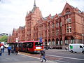 Holborn Bars, built as the headquarters of the Prudential Assurance Company
 -
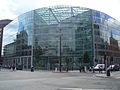 The headquarters of J Sainsbury plc at Holborn Circus
 -
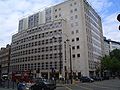
 Staple Inn building near Chancery Lane tube station
 -
 Grange Holborn Hotel in Holborn
 -

-
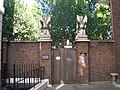 Entrance to Gray's Inn


External links
- Holborn and Bloomsbury, by Sir Walter Besant and Geraldine Edith Mitton, 1903, from Project Gutenberg


| Districts |
|  |
|---|---|---|
| Attractions |
| |
| Parks and open spaces | ||
| Constituencies | ||
| Local government | ||
| Bridges | ||
| Rail and tube stations |
| |
| Art and architecture |
| |
| Other topics | ||